Mark Trail Wilderness Boundry To Old Turnpike Crossing Near Vandiver Branch River Run
Community Reviews
Been here? Share the conditions.
Reviews, ratings & photos are added in the free Snoflo iOS app — rate a spot, tag the conditions, and your visit is verified by location. Add or manage your reviews from the app.
Mark Trail Wilderness Boundry To Old Turnpike Crossing Near Vandiver Branch
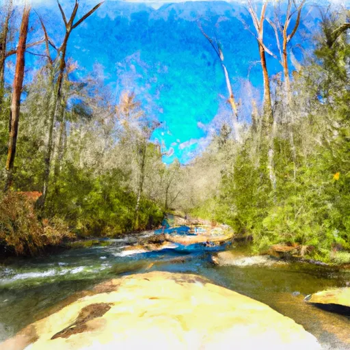
The Whitewater River Run in the Mark Trail Wilderness Boundary to Old Turnpike Crossing Near Vandiver Branch in Georgia is a popular spot for whitewater enthusiasts. The ideal streamflow range for this stretch of river is between 150-400 cubic feet per second (cfs). The run is rated as Class II-III, making it suitable for intermediate paddlers. The segment mileage is approximately 4.5 miles long, which can usually be completed within 2-3 hours.
Some specific river rapids and obstacles along the Whitewater River Run include the Big Rocks, the S Turn, and the Pinball Rapid. The Big Rocks is a series of small rapids that require paddlers to maneuver around large boulders. The S Turn is a sharp turn in the river that requires skillful maneuvering to navigate around. The Pinball Rapid consists of several large rocks that create a bouncy ride down the river.
Specific regulations to the area include the requirement to wear a personal flotation device (PFD) at all times while on the river. The minimum age for paddlers is 8 years old, and anyone under 18 years old must be accompanied by an adult. Camping is prohibited within 200 feet of the river bank, and fires are only allowed in designated fire rings.
Overall, the Whitewater River Run in the Mark Trail Wilderness Boundary to Old Turnpike Crossing Near Vandiver Branch in Georgia is a thrilling stretch of river that offers challenges to intermediate paddlers. It is important to follow all regulations and safety precautions to ensure a safe and enjoyable experience.
Plan your run down to the hour
Same weather feed Snoflo's iOS app uses -- updated continuously from NOAA / yr.no. Watch the precipitation column on the meteogram; rain ahead of a run typically lifts flows 12-48 hours later depending on the basin.
Next 5 days, hour by hour
Temperature line with weather symbols on top, snow + rain accumulation as columns, humidity as a dotted line.
5-day forecast table
Every 3 hours, broken out across temperature, snow, rain, humidity, and wind. Each cell is colour-coded relative to the column min/max.
| Time | Condition | Temp (°F) | Snow (in) | Rain (in) | Humidity (%) | Wind (mps) | Wind dir |
|---|---|---|---|---|---|---|---|
| Loading detailed forecast… | |||||||
15-day temperature & precipitation
Daily temperatures, snow, and rain projected over the next two weeks -- the upstream story that drives next week's flows.
Regional streamflow levels
USGS streamgauges around Mark Trail Wilderness Boundry To Old Turnpike Crossing Near Vandiver Branch -- useful for spotting upstream pulses and gauging which tributary is contributing what.
| Streamgauge | Discharge | View |
|---|---|---|
| Chattahoochee River At Helen | 52 cfs | → |
| Nottely River Near Blairsville | 71 cfs | → |
| Tallulah River Near Clayton | 103 cfs | → |
| Chattahoochee River Near Leaf | 148 cfs | → |
| Chattahoochee River Near Cornelia | 300 cfs | → |
| Chestatee River Near Dahlonega | 121 cfs | → |
Plan a longer trip
The closest boat launches, other paddle runs, and campgrounds so a day on the water can grow into a full weekend.
Boat launches
- Mountain Shadows Drive White County
- Mayor's Park
- Upper Chatuge Lloyds Landing
- Boundary Waters Resort & Marina
- Lake Chatuge Towns County
- Moccasin Creek
Other river runs
- Old Turnpike Crossing To Martin Branch Bridge
- Source Near Chattahoochee Gap To Mark Trail Wilderness Boundary
- Martin Branch Bridge To Robertsontown Bridge On Ga Highway 356
- Headwaters In Standing Indian Basin To Slackwater Of Natahala Lake
- Confluence Of Brasstown Creek And Little Brasstown Creek Just South Of Brasstown Falls Road (Fs 751) To Confluence Of Mill Branch, Brasstown Creek And Boatwright Creek Near Boatwright Road (Fs 753)
Campgrounds
- Upper Chattahoochee River
- Upper Chattahoochee River Campground
- Andrews Cove Campground
- Andrews Cove Campsite
- Andrews Cove
- Low Gap Creek
Fishing spots
Whitewater safety
- Check the flow before you run
- Use the linked-gauge card and Regional Flow panel above. Class ratings change with flow -- a Class III at low water can become Class IV+ at high water.
- Know your skill ceiling
- Pick runs comfortably below your ceiling. Cold-water and big-water runs raise the consequences of any mistake.
- Wear the right gear
- Helmet, PFD, drysuit / wetsuit when water is below 60°F. Throw bag, knife, and whistle on your person, not in the boat.
- Scout, set safety, and run with a team
- Scout new rapids on foot, set safety with throw bags above the consequence pool, and run with at least one other competent paddler.
- Respect the river
- Strainers, undercuts, low-head dams, and wood can kill at any class rating. When in doubt, portage.
Set push alerts in the Snoflo app
Save Mark Trail Wilderness Boundry To Old Turnpike Crossing Near Vandiver Branch as a favorite, set a discharge threshold (e.g. "alert me when flow hits 600 cfs"), and the iOS app pushes the moment the linked gauge crosses.
About Mark Trail Wilderness Boundry To Old Turnpike Crossing Near Vandiver Branch
What's the optimal flow for Mark Trail Wilderness Boundry To Old Turnpike Crossing Near Vandiver Branch?
The optimal flow depends on the section and the craft. Check the Run Details panel for the linked gauge and current status.
How fresh is the cfs reading on this page?
The linked USGS streamgauge reports continuously (every 15 minutes); Snoflo refreshes throughout the day. Hover the streamflow sparkline to read individual datapoints.
What's the whitewater class?
See the Run Details panel for the class rating Snoflo tracks for this run. Class ratings change with flow -- a Class III at low water can become Class IV in high water.
Where do I put in / take out?
Tap Directions in the hero above to open driving directions to the put-in. For shuttle planning, check the Nearby Boat Launches panel and the river run operator's site.
Can I get alerts when flows hit the optimal range?
Yes -- alerts are managed in the Snoflo iOS app. Favorite this run, set a discharge threshold, and you'll get a push the moment the gauge crosses.
Other runs near here
Snoflo-tracked paddle runs within driving distance of Mark Trail Wilderness Boundry To Old Turnpike Crossing Near Vandiver Branch.