Deadwood Reservoir To Confluence With Warm Springs Creek River Run
Community Reviews
Been here? Share the conditions.
Reviews, ratings & photos are added in the free Snoflo iOS app — rate a spot, tag the conditions, and your visit is verified by location. Add or manage your reviews from the app.
Deadwood Reservoir To Confluence With Warm Springs Creek
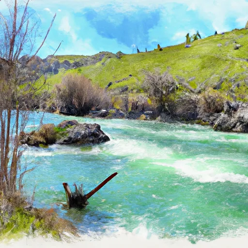
The segment mileage for this run is approximately 12 miles, starting from the Deadwood Reservoir and ending at the confluence with Warm Springs Creek. Throughout the run, paddlers will encounter several notable rapids, including Jackass, Disneyland, and Horseshoe. These rapids are known for their technical challenges and require precise navigation.
In terms of regulations, the Deadwood Reservoir to Confluence with Warm Springs Creek run is located within the Boise National Forest and is subject to specific rules and restrictions enforced by the Forest Service. These regulations include camping restrictions, fire restrictions, and the use of proper safety equipment such as helmets and life jackets. Paddlers are also advised to practice Leave No Trace principles and respect the natural environment by avoiding littering and minimizing their impact on the river ecosystem.
Overall, the Deadwood Reservoir to Confluence with Warm Springs Creek run is a challenging and rewarding river run that requires intermediate to advanced skill levels and careful attention to safety regulations and environmental impact.
Plan your run down to the hour
Same weather feed Snoflo's iOS app uses -- updated continuously from NOAA / yr.no. Watch the precipitation column on the meteogram; rain ahead of a run typically lifts flows 12-48 hours later depending on the basin.
Next 5 days, hour by hour
Temperature line with weather symbols on top, snow + rain accumulation as columns, humidity as a dotted line.
5-day forecast table
Every 3 hours, broken out across temperature, snow, rain, humidity, and wind. Each cell is colour-coded relative to the column min/max.
| Time | Condition | Temp (°F) | Snow (in) | Rain (in) | Humidity (%) | Wind (mps) | Wind dir |
|---|---|---|---|---|---|---|---|
| Loading detailed forecast… | |||||||
15-day temperature & precipitation
Daily temperatures, snow, and rain projected over the next two weeks -- the upstream story that drives next week's flows.
Regional streamflow levels
USGS streamgauges around Deadwood Reservoir To Confluence With Warm Springs Creek -- useful for spotting upstream pulses and gauging which tributary is contributing what.
| Streamgauge | Discharge | View |
|---|---|---|
| Deadwood River Bl Deadwood Res Nr Lowman Id | 848 cfs | → |
| Sf Payette River At Lowman Id | 500 cfs | → |
| Middle Fork Payette River Nr Crouch Id | 128 cfs | → |
| Nf Payette River Nr Banks Id | 1,410 cfs | → |
| Valley Creek At Stanley Id | 124 cfs | → |
| Payette River Nr Horseshoe Bend Id | 2,980 cfs | → |
Plan a longer trip
The closest boat launches, other paddle runs, and campgrounds so a day on the water can grow into a full weekend.
Other river runs
- Headwaters To Deadwood Reservoir
- Warm Springs Creek To Confluence With Pine Creek
- Boiling Springs Cabin To Confluence With Fool Creek
- Fcronr Wilderness Boundary To Confluence With North Fork Elk Creek
- Confluence With Bell Creek To Boiling Springs Cabin
Campgrounds
- Cozy Cove Campground
- Cozy Cove
- Cozy Cove Campground - Reserve
- Homers
- Homer's Campground
- Hower's Campground - Reserve
Fishing spots
Whitewater safety
- Check the flow before you run
- Use the linked-gauge card and Regional Flow panel above. Class ratings change with flow -- a Class III at low water can become Class IV+ at high water.
- Know your skill ceiling
- Pick runs comfortably below your ceiling. Cold-water and big-water runs raise the consequences of any mistake.
- Wear the right gear
- Helmet, PFD, drysuit / wetsuit when water is below 60°F. Throw bag, knife, and whistle on your person, not in the boat.
- Scout, set safety, and run with a team
- Scout new rapids on foot, set safety with throw bags above the consequence pool, and run with at least one other competent paddler.
- Respect the river
- Strainers, undercuts, low-head dams, and wood can kill at any class rating. When in doubt, portage.
Set push alerts in the Snoflo app
Save Deadwood Reservoir To Confluence With Warm Springs Creek as a favorite, set a discharge threshold (e.g. "alert me when flow hits 600 cfs"), and the iOS app pushes the moment the linked gauge crosses.
About Deadwood Reservoir To Confluence With Warm Springs Creek
What's the optimal flow for Deadwood Reservoir To Confluence With Warm Springs Creek?
The optimal flow depends on the section and the craft. Check the Run Details panel for the linked gauge and current status.
How fresh is the cfs reading on this page?
The linked USGS streamgauge reports continuously (every 15 minutes); Snoflo refreshes throughout the day. Hover the streamflow sparkline to read individual datapoints.
What's the whitewater class?
See the Run Details panel for the class rating Snoflo tracks for this run. Class ratings change with flow -- a Class III at low water can become Class IV in high water.
Where do I put in / take out?
Tap Directions in the hero above to open driving directions to the put-in. For shuttle planning, check the Nearby Boat Launches panel and the river run operator's site.
Can I get alerts when flows hit the optimal range?
Yes -- alerts are managed in the Snoflo iOS app. Favorite this run, set a discharge threshold, and you'll get a push the moment the gauge crosses.
Other runs near here
Snoflo-tracked paddle runs within driving distance of Deadwood Reservoir To Confluence With Warm Springs Creek.