Source, Sec. 19, T39n, R13e To Road #581 Near Moose Ck, Sec. 16, T39n, R11i River Run
Community Reviews
Been here? Share the conditions.
Reviews, ratings & photos are added in the free Snoflo iOS app — rate a spot, tag the conditions, and your visit is verified by location. Add or manage your reviews from the app.
Source, Sec. 19, T39n, R13e To Road #581 Near Moose Ck, Sec. 16, T39n, R11i
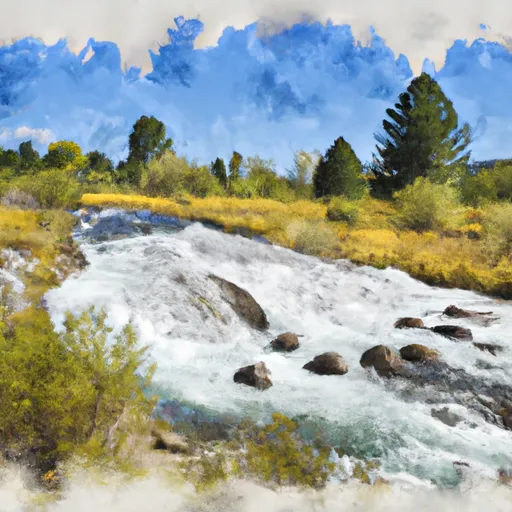
The river features several notable rapids and obstacles, including Devil's Tooth, a Class IV rapid that requires experienced maneuvering; Growler, a steep drop that can cause flips and wraps; and a tight canyon section known as the Squeeze. Paddlers should be prepared for technical maneuvering, rocks and boulders, and swift currents throughout the run.
Specific regulations to the area include a permit requirement for commercial outfitters, as well as a requirement to pack out all trash. The run is also subject to seasonal closures and restrictions, so paddlers should check with local authorities before planning their trip.
Sources consulted for this information include American Whitewater and Idaho River Sports.
Plan your run down to the hour
Same weather feed Snoflo's iOS app uses -- updated continuously from NOAA / yr.no. Watch the precipitation column on the meteogram; rain ahead of a run typically lifts flows 12-48 hours later depending on the basin.
Next 5 days, hour by hour
Temperature line with weather symbols on top, snow + rain accumulation as columns, humidity as a dotted line.
5-day forecast table
Every 3 hours, broken out across temperature, snow, rain, humidity, and wind. Each cell is colour-coded relative to the column min/max.
| Time | Condition | Temp (°F) | Snow (in) | Rain (in) | Humidity (%) | Wind (mps) | Wind dir |
|---|---|---|---|---|---|---|---|
| Loading detailed forecast… | |||||||
15-day temperature & precipitation
Daily temperatures, snow, and rain projected over the next two weeks -- the upstream story that drives next week's flows.
Regional streamflow levels
USGS streamgauges around Source, Sec. 19, T39n, R13e To Road #581 Near Moose Ck, Sec. 16, T39n, R11i -- useful for spotting upstream pulses and gauging which tributary is contributing what.
| Streamgauge | Discharge | View |
|---|---|---|
| St. Joe River At Red Ives Ranger Station Id | 107 cfs | → |
| Nf Clearwater River Nr Canyon Ranger Station Id | 1,080 cfs | → |
| St. Regis River Near St. Regis | 107 cfs | → |
| Clark Fork At St. Regis Mt | 3,320 cfs | → |
| Lochsa River Nr Lowell Id | 766 cfs | → |
| Clark Fork Below Missoula Mt | 2,310 cfs | → |
Plan a longer trip
The closest boat launches, other paddle runs, and campgrounds so a day on the water can grow into a full weekend.
Other river runs
- Proposed Hoodoo Wilderness Boundary, Sec. 28, T10n, R26w To Mouth, Clearwater Nf
- Road 581, Sec. 19, T39n, R13e To Mouth, Sec. 18, T39n, R10e
- Middle Fork Indian Creek Headwaters, Sec. 14, T12n, R26w To Mainstem, Sec. 25, T12n, R26w
- Irish Creek Headwaters, Sec. 20, T12n, R25w To Mainstem, Sec. 22, T12n, R25w
- Cedar Log Creek Headwaters, Sec. 14, T12n, R26w To Mainstem, Sec. 19, T13n, R25w
Campgrounds
Whitewater safety
- Check the flow before you run
- Use the linked-gauge card and Regional Flow panel above. Class ratings change with flow -- a Class III at low water can become Class IV+ at high water.
- Know your skill ceiling
- Pick runs comfortably below your ceiling. Cold-water and big-water runs raise the consequences of any mistake.
- Wear the right gear
- Helmet, PFD, drysuit / wetsuit when water is below 60°F. Throw bag, knife, and whistle on your person, not in the boat.
- Scout, set safety, and run with a team
- Scout new rapids on foot, set safety with throw bags above the consequence pool, and run with at least one other competent paddler.
- Respect the river
- Strainers, undercuts, low-head dams, and wood can kill at any class rating. When in doubt, portage.
Set push alerts in the Snoflo app
Save Source, Sec. 19, T39n, R13e To Road #581 Near Moose Ck, Sec. 16, T39n, R11i as a favorite, set a discharge threshold (e.g. "alert me when flow hits 600 cfs"), and the iOS app pushes the moment the linked gauge crosses.
About Source, Sec. 19, T39n, R13e To Road #581 Near Moose Ck, Sec. 16, T39n, R11i
What's the optimal flow for Source, Sec. 19, T39n, R13e To Road #581 Near Moose Ck, Sec. 16, T39n, R11i?
The optimal flow depends on the section and the craft. Check the Run Details panel for the linked gauge and current status.
How fresh is the cfs reading on this page?
The linked USGS streamgauge reports continuously (every 15 minutes); Snoflo refreshes throughout the day. Hover the streamflow sparkline to read individual datapoints.
What's the whitewater class?
See the Run Details panel for the class rating Snoflo tracks for this run. Class ratings change with flow -- a Class III at low water can become Class IV in high water.
Where do I put in / take out?
Tap Directions in the hero above to open driving directions to the put-in. For shuttle planning, check the Nearby Boat Launches panel and the river run operator's site.
Can I get alerts when flows hit the optimal range?
Yes -- alerts are managed in the Snoflo iOS app. Favorite this run, set a discharge threshold, and you'll get a push the moment the gauge crosses.
Other runs near here
Snoflo-tracked paddle runs within driving distance of Source, Sec. 19, T39n, R13e To Road #581 Near Moose Ck, Sec. 16, T39n, R11i.