Bitterroot River Fishing
As of July 24, 2026, the nearest streamgauge to Bitterroot River — Clark Fork Below Missoula Mt — reports 3,160 cfs. Source: USGS gauge data, refreshed throughout the day.
Community Reviews
Been here? Share the conditions.
Reviews, ratings & photos are added in the free Snoflo iOS app — rate a spot, tag the conditions, and your visit is verified by location. Add or manage your reviews from the app.
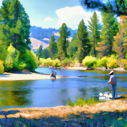
Bitterroot River
What's biting at Bitterroot River
Species commonly reported here -- tap any card for techniques, target seasons, and other waters where it's been caught.
Plan your trip down to the hour
Same weather feed Snoflo's iOS app uses -- updated continuously from NOAA / yr.no.
Next 5 days, hour by hour
Temperature line with weather symbols on top, snow + rain accumulation as columns, humidity as a dotted line.
5-day forecast table
Every 3 hours, broken out across temperature, snow, rain, humidity, and wind. Each cell is colour-coded relative to the column min/max so trends jump out at a glance.
| Time | Condition | Temp (°F) | Snow (in) | Rain (in) | Humidity (%) | Wind (mps) | Wind dir |
|---|---|---|---|---|---|---|---|
| Loading detailed forecast… | |||||||
15-day temperature & precipitation
Daily temperatures, snow, and rain projected over the next two weeks. Hover any point for the full breakdown.
Nearby streamflow
USGS streamgauges within reach of Bitterroot River -- updated continuously from the National Water Information System.
| Streamgauge | Discharge | View |
|---|---|---|
| Clark Fork Below Missoula Mt | 3,160 cfs | → |
| Bitterroot River Near Missoula Mt | 974 cfs | → |
| Clark Fork Above Missoula Mt | 2,170 cfs | → |
| Clark Fork At Turah Bridge Nr Bonner Mt | 1,020 cfs | → |
| Blackfoot River Near Bonner Mt | 1,120 cfs | → |
| Rock Creek Near Clinton Mt | 495 cfs | → |
Plan a longer trip
The closest campgrounds, parks, boat launches, and reservoirs so a fishing run can grow into a weekend.
Campgrounds
- Missoula Koa
- Lewis And Clark
- Lolo Creek
- Lolo Creek Campground And Picnic Area
- Chief Looking Glass Fas
- Earl Tennant
Parks
- Council Grove State Park
- Playfair Park
- Missoula Memorial Rose Garden
- Greenough Park
- Travelers' Rest State Park
- Frenchtown Pond State Park
Reservoirs
- Kona Ranch
- Spartan/Playfair Park Retention Basins
- Smurfit-Stone Container Storage Ponds
- Carlton Lake #1
- Peterson Lake
- Mckinley Lake
Boat launches
Points of interest
- Historical Museum At Fort Missoula
- National Museum Of Forest Service History
- Studio Greytak
- E3 Convergance Gallery
- The Artists' Shop
- Radius Gallery
Paddle runs
- Mainstem Headwaters, Sec. 4, T15n, R18w To Boundary, Sec. 2, T13n, R18w
- Spring Gulch Headwaters, Sec. 12, T14n, R19w To Mainstem, Sec. 35, T14n, R19w
- Missoula Town Run
- Mainstem Headwaters, Sec. 35, T10n, R22w To South Fork Lolo Creek Trailhead, Sec. 12, T11n, R22w
- East Fork Headwaters, Sec. 8, T14n, R17w To Mainstem, Sec. 14, T14n, R18w
- High Falls Creek Headwaters, Sec. 5, T14n, R18w To Mainstem, Sec. 2, T14n, R18w
Angling safety & ethics
- Know the regulations
- Check local fishing rules, seasons, size limits, and license requirements to ensure legal and sustainable angling.
- Handle fish responsibly
- Use wet hands, minimize air exposure, and release fish gently to improve survival rates when practicing catch-and-release.
- Choose the right gear
- Match your rod, line, and tackle to the species and conditions to increase success and reduce unnecessary harm to fish.
- Respect the waterway
- Avoid disturbing habitat, prevent bank erosion, and keep a safe distance from spawning areas to protect ecosystems.
- Keep it clean
- Pack out all line, hooks, bait containers, and trash. Discarded gear can injure wildlife and degrade waterways.
Set push alerts in the Snoflo app
Save Bitterroot River as a favorite, set a custom threshold (water temperature, streamflow, snowpack), and the iOS app will push the moment conditions cross.
About Bitterroot River
What fish species are found at Bitterroot River?
Snoflo tracks the species commonly reported at Bitterroot River -- see the Fish Species panel above for the live list with images and links to per-species pages.
How fresh is the weather data on this page?
The hourly forecast updates throughout the day from the NOAA / yr.no public feeds. Streamflow data comes live from USGS streamgauges, also refreshed continuously.
Can I get alerts when conditions change?
Yes -- alerts are managed through the Snoflo iOS app. Favorite this area, set a threshold (water temperature, streamflow, snowpack), and you'll get a push the moment it crosses.
Do I need a fishing license?
Yes. Check your state agency's regulations for license requirements, seasons, size limits, and any waterbody-specific rules before fishing Bitterroot River.
How do I get to Bitterroot River?
Tap Open in map in the hero above to center the Snoflo interactive map on this area, or grab the coordinates from the location facts panel.
Other angling spots near here
Snoflo-tracked fishing areas within driving distance of Bitterroot River.