Trail Creek To Confluence With Crank Creek River Run
Community Reviews
Been here? Share the conditions.
Reviews, ratings & photos are added in the free Snoflo iOS app — rate a spot, tag the conditions, and your visit is verified by location. Add or manage your reviews from the app.
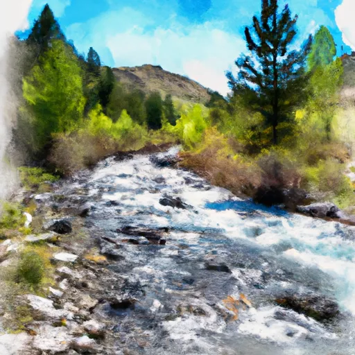
Trail Creek To Confluence With Crank Creek
Some of the specific rapids and obstacles along this stretch of the river include the Meat Grinder, a technical rapid with several chutes and boulders to navigate, and the Washing Machine, a powerful hydraulic feature that requires precise boat control. The river also features several large waves and holes that can provide thrilling surf opportunities.
It is important to note that this section of the river is within the Curlew National Grassland, which is managed by the U.S. Forest Service. Therefore, there are specific regulations to be aware of when visiting the area. These include restrictions on camping, campfires, and alcohol consumption. Additionally, all visitors must obtain a Recreation Pass from the Forest Service before entering the area.
Overall, the Whitewater River Run on Trail Creek to Confluence with Crank Creek is a challenging and exciting whitewater experience that requires skill and experience to navigate safely. Visitors should be aware of the ideal streamflow range, class rating, and specific rapids and obstacles, as well as the regulations in place for the area.
Plan your run down to the hour
Same weather feed Snoflo's iOS app uses -- updated continuously from NOAA / yr.no. Watch the precipitation column on the meteogram; rain ahead of a run typically lifts flows 12-48 hours later depending on the basin.
Next 5 days, hour by hour
Temperature line with weather symbols on top, snow + rain accumulation as columns, humidity as a dotted line.
5-day forecast table
Every 3 hours, broken out across temperature, snow, rain, humidity, and wind. Each cell is colour-coded relative to the column min/max.
| Time | Condition | Temp (°F) | Snow (in) | Rain (in) | Humidity (%) | Wind (mps) | Wind dir |
|---|---|---|---|---|---|---|---|
| Loading detailed forecast… | |||||||
15-day temperature & precipitation
Daily temperatures, snow, and rain projected over the next two weeks -- the upstream story that drives next week's flows.
Regional streamflow levels
USGS streamgauges around Trail Creek To Confluence With Crank Creek -- useful for spotting upstream pulses and gauging which tributary is contributing what.
| Streamgauge | Discharge | View |
|---|---|---|
| Sf Boise River At Neal Bridge Nr Arrowrock Dam Id | 360 cfs | → |
| Boise River Nr Twin Springs Id | 433 cfs | → |
| Mores Creek Ab Robie Creek Nr Arrowrock Dam Id | 24 cfs | → |
| Sf Boise River At Anderson Ranch Dam Id | 1,570 cfs | → |
| Cottonwood Creek Bel Fivemile Cr Nr Boise Id | 1 cfs | → |
| Canyon Cr At Oregon Trail Xing Nr Mountain Home Id | 0 cfs | → |
Plan a longer trip
The closest boat launches, other paddle runs, and campgrounds so a day on the water can grow into a full weekend.
Boat launches
- Cinch Creek
- Macks Creek
- Danskin Floatboat Access
- Spring Shores
- National Forest Development Road 113 Elmore County
- Robie Creek Road Boise County
Other river runs
- Boise Nf Boundary To Confluence With Willow Creek
- Mennecke Creek To Confluence With Trail Creek
- Anderson Ranch Dam To Confluence With Mennecke Creek
- Confluence With Rabbit Creek To Confluence With Middle Fork Boise River
- Confluence With Granite Creek To Confluence With Pine Creek
Whitewater safety
- Check the flow before you run
- Use the linked-gauge card and Regional Flow panel above. Class ratings change with flow -- a Class III at low water can become Class IV+ at high water.
- Know your skill ceiling
- Pick runs comfortably below your ceiling. Cold-water and big-water runs raise the consequences of any mistake.
- Wear the right gear
- Helmet, PFD, drysuit / wetsuit when water is below 60°F. Throw bag, knife, and whistle on your person, not in the boat.
- Scout, set safety, and run with a team
- Scout new rapids on foot, set safety with throw bags above the consequence pool, and run with at least one other competent paddler.
- Respect the river
- Strainers, undercuts, low-head dams, and wood can kill at any class rating. When in doubt, portage.
Set push alerts in the Snoflo app
Save Trail Creek To Confluence With Crank Creek as a favorite, set a discharge threshold (e.g. "alert me when flow hits 600 cfs"), and the iOS app pushes the moment the linked gauge crosses.
About Trail Creek To Confluence With Crank Creek
What's the optimal flow for Trail Creek To Confluence With Crank Creek?
The optimal flow depends on the section and the craft. Check the Run Details panel for the linked gauge and current status.
How fresh is the cfs reading on this page?
The linked USGS streamgauge reports continuously (every 15 minutes); Snoflo refreshes throughout the day. Hover the streamflow sparkline to read individual datapoints.
What's the whitewater class?
See the Run Details panel for the class rating Snoflo tracks for this run. Class ratings change with flow -- a Class III at low water can become Class IV in high water.
Where do I put in / take out?
Tap Directions in the hero above to open driving directions to the put-in. For shuttle planning, check the Nearby Boat Launches panel and the river run operator's site.
Can I get alerts when flows hit the optimal range?
Yes -- alerts are managed in the Snoflo iOS app. Favorite this run, set a discharge threshold, and you'll get a push the moment the gauge crosses.
Other runs near here
Snoflo-tracked paddle runs within driving distance of Trail Creek To Confluence With Crank Creek.