Mennecke Creek To Confluence With Trail Creek River Run
Community Reviews
Been here? Share the conditions.
Reviews, ratings & photos are added in the free Snoflo iOS app — rate a spot, tag the conditions, and your visit is verified by location. Add or manage your reviews from the app.
Mennecke Creek To Confluence With Trail Creek
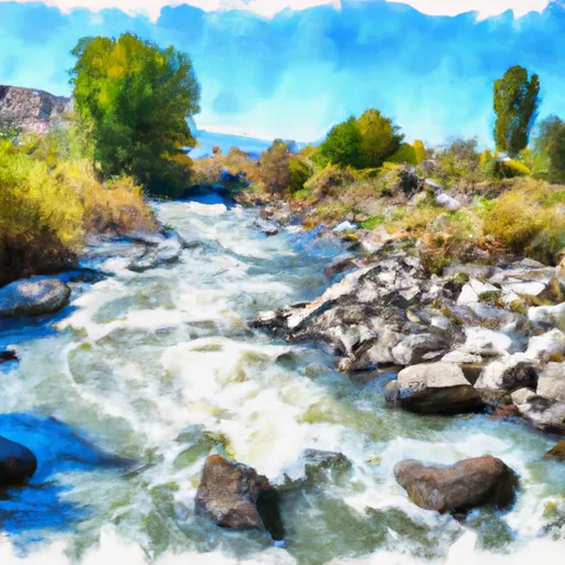
This section of the river covers a distance of 7 miles, with several challenging rapids and obstacles along the way. Some of the notable rapids include Pinball, Bumper Car, and The Toilet Bowl, which require precise navigation and technical skills to successfully maneuver. The river also features numerous boulder gardens, steep drops, and tight channels that demand the paddler's attention.
While there are no specific regulations for this area, visitors are encouraged to use proper safety equipment, including helmets, life jackets, and appropriate footwear. It is also recommended to paddle with a partner or in a group and to avoid paddling during extreme weather conditions. Additionally, visitors are expected to follow Leave No Trace principles and to respect private property along the riverbanks.
Overall, the Mennecke Creek to Trail Creek stretch of the Whitewater River offers a thrilling and challenging adventure for experienced paddlers who are looking for a technical and remote river run.
Plan your run down to the hour
Same weather feed Snoflo's iOS app uses -- updated continuously from NOAA / yr.no. Watch the precipitation column on the meteogram; rain ahead of a run typically lifts flows 12-48 hours later depending on the basin.
Next 5 days, hour by hour
Temperature line with weather symbols on top, snow + rain accumulation as columns, humidity as a dotted line.
5-day forecast table
Every 3 hours, broken out across temperature, snow, rain, humidity, and wind. Each cell is colour-coded relative to the column min/max.
| Time | Condition | Temp (°F) | Snow (in) | Rain (in) | Humidity (%) | Wind (mps) | Wind dir |
|---|---|---|---|---|---|---|---|
| Loading detailed forecast… | |||||||
15-day temperature & precipitation
Daily temperatures, snow, and rain projected over the next two weeks -- the upstream story that drives next week's flows.
Regional streamflow levels
USGS streamgauges around Mennecke Creek To Confluence With Trail Creek -- useful for spotting upstream pulses and gauging which tributary is contributing what.
| Streamgauge | Discharge | View |
|---|---|---|
| Sf Boise River At Neal Bridge Nr Arrowrock Dam Id | 360 cfs | → |
| Sf Boise River At Anderson Ranch Dam Id | 1,560 cfs | → |
| Canyon Cr At Oregon Trail Xing Nr Mountain Home Id | 0 cfs | → |
| Sf Boise River Nr Featherville Id | 196 cfs | → |
| Boise River Nr Twin Springs Id | 386 cfs | → |
| Mores Creek Ab Robie Creek Nr Arrowrock Dam Id | 20 cfs | → |
Plan a longer trip
The closest boat launches, other paddle runs, and campgrounds so a day on the water can grow into a full weekend.
Boat launches
- Danskin Floatboat Access
- National Forest Development Road 113 Elmore County
- Elk Creek
- Evans Creek
- Fall Creek
- Camas Reservoir Road Elmore County
Whitewater safety
- Check the flow before you run
- Use the linked-gauge card and Regional Flow panel above. Class ratings change with flow -- a Class III at low water can become Class IV+ at high water.
- Know your skill ceiling
- Pick runs comfortably below your ceiling. Cold-water and big-water runs raise the consequences of any mistake.
- Wear the right gear
- Helmet, PFD, drysuit / wetsuit when water is below 60°F. Throw bag, knife, and whistle on your person, not in the boat.
- Scout, set safety, and run with a team
- Scout new rapids on foot, set safety with throw bags above the consequence pool, and run with at least one other competent paddler.
- Respect the river
- Strainers, undercuts, low-head dams, and wood can kill at any class rating. When in doubt, portage.
Set push alerts in the Snoflo app
Save Mennecke Creek To Confluence With Trail Creek as a favorite, set a discharge threshold (e.g. "alert me when flow hits 600 cfs"), and the iOS app pushes the moment the linked gauge crosses.
About Mennecke Creek To Confluence With Trail Creek
What's the optimal flow for Mennecke Creek To Confluence With Trail Creek?
The optimal flow depends on the section and the craft. Check the Run Details panel for the linked gauge and current status.
How fresh is the cfs reading on this page?
The linked USGS streamgauge reports continuously (every 15 minutes); Snoflo refreshes throughout the day. Hover the streamflow sparkline to read individual datapoints.
What's the whitewater class?
See the Run Details panel for the class rating Snoflo tracks for this run. Class ratings change with flow -- a Class III at low water can become Class IV in high water.
Where do I put in / take out?
Tap Directions in the hero above to open driving directions to the put-in. For shuttle planning, check the Nearby Boat Launches panel and the river run operator's site.
Can I get alerts when flows hit the optimal range?
Yes -- alerts are managed in the Snoflo iOS app. Favorite this run, set a discharge threshold, and you'll get a push the moment the gauge crosses.
Other runs near here
Snoflo-tracked paddle runs within driving distance of Mennecke Creek To Confluence With Trail Creek.