Wilderness Boundary To Confluence With Middle Fork Salmon River River Run
Community Reviews
Been here? Share the conditions.
Reviews, ratings & photos are added in the free Snoflo iOS app — rate a spot, tag the conditions, and your visit is verified by location. Add or manage your reviews from the app.
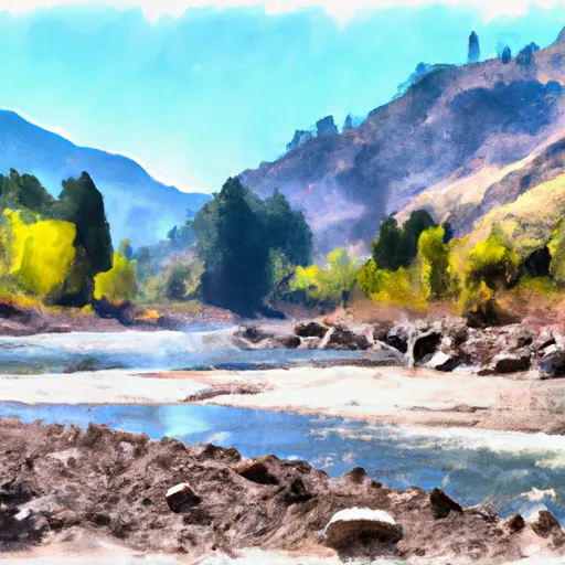
Wilderness Boundary To Confluence With Middle Fork Salmon River
Devil's Tooth is a notorious class IV rapid that requires precise maneuvering through a narrow chute with a large boulder at the bottom. Granite Creek is another challenging rapid with multiple drops and tight turns that demand technical paddling skills. The segment also features several other class III rapids that offer fun and exciting challenges.
The area is regulated by the United States Forest Service, which requires all boaters to obtain a permit to access the river. Additionally, the agency has specific regulations in place to protect the environment and ensure visitor safety. For example, all boaters must carry a personal flotation device and abide by fire restrictions and waste disposal guidelines.
In summary, the Wilderness Boundary to Confluence with Middle Fork Salmon River in Idaho offers a thrilling whitewater experience for paddlers with intermediate to advanced skills. The segment requires precise maneuvering through challenging class III-IV rapids, and visitors must comply with specific regulations to ensure their safety and protect the environment.
Plan your run down to the hour
Same weather feed Snoflo's iOS app uses -- updated continuously from NOAA / yr.no. Watch the precipitation column on the meteogram; rain ahead of a run typically lifts flows 12-48 hours later depending on the basin.
Next 5 days, hour by hour
Temperature line with weather symbols on top, snow + rain accumulation as columns, humidity as a dotted line.
5-day forecast table
Every 3 hours, broken out across temperature, snow, rain, humidity, and wind. Each cell is colour-coded relative to the column min/max.
| Time | Condition | Temp (°F) | Snow (in) | Rain (in) | Humidity (%) | Wind (mps) | Wind dir |
|---|---|---|---|---|---|---|---|
| Loading detailed forecast… | |||||||
15-day temperature & precipitation
Daily temperatures, snow, and rain projected over the next two weeks -- the upstream story that drives next week's flows.
Regional streamflow levels
USGS streamgauges around Wilderness Boundary To Confluence With Middle Fork Salmon River -- useful for spotting upstream pulses and gauging which tributary is contributing what.
| Streamgauge | Discharge | View |
|---|---|---|
| Mf Salmon River At Mf Lodge Nr Yellow Pine Id | 733 cfs | → |
| Ef Of Sf Salmon River At Stibnite Id | 46 cfs | → |
| Efsf Salmon R Abv Sugar Crk Nr Stibnite | 82 cfs | → |
| Sugar Creek Nr Stibnite | 37 cfs | → |
| Johnson Creek At Yellow Pine Id | 94 cfs | → |
| Valley Creek At Stanley Id | 109 cfs | → |
Plan a longer trip
The closest boat launches, other paddle runs, and campgrounds so a day on the water can grow into a full weekend.
Other river runs
- Float Creek To Middle Fork Of The Salmon
- Headwaters To 1 Mile Downstream Of Cut Throat Lake
- Headwaters To 1 Mile Downstream Of Soldier Lake
- Boundary Creek To Cache Bar
Campgrounds
- Rapid River Campsite
- Dolly Lake Campsite
- Big Snag Campsite
- Dome Hole Campsite
- Greyhound Campsite
- Oakie Point Campsite
Fishing spots
Whitewater safety
- Check the flow before you run
- Use the linked-gauge card and Regional Flow panel above. Class ratings change with flow -- a Class III at low water can become Class IV+ at high water.
- Know your skill ceiling
- Pick runs comfortably below your ceiling. Cold-water and big-water runs raise the consequences of any mistake.
- Wear the right gear
- Helmet, PFD, drysuit / wetsuit when water is below 60°F. Throw bag, knife, and whistle on your person, not in the boat.
- Scout, set safety, and run with a team
- Scout new rapids on foot, set safety with throw bags above the consequence pool, and run with at least one other competent paddler.
- Respect the river
- Strainers, undercuts, low-head dams, and wood can kill at any class rating. When in doubt, portage.
Set push alerts in the Snoflo app
Save Wilderness Boundary To Confluence With Middle Fork Salmon River as a favorite, set a discharge threshold (e.g. "alert me when flow hits 600 cfs"), and the iOS app pushes the moment the linked gauge crosses.
About Wilderness Boundary To Confluence With Middle Fork Salmon River
What's the optimal flow for Wilderness Boundary To Confluence With Middle Fork Salmon River?
The optimal flow depends on the section and the craft. Check the Run Details panel for the linked gauge and current status.
How fresh is the cfs reading on this page?
The linked USGS streamgauge reports continuously (every 15 minutes); Snoflo refreshes throughout the day. Hover the streamflow sparkline to read individual datapoints.
What's the whitewater class?
See the Run Details panel for the class rating Snoflo tracks for this run. Class ratings change with flow -- a Class III at low water can become Class IV in high water.
Where do I put in / take out?
Tap Directions in the hero above to open driving directions to the put-in. For shuttle planning, check the Nearby Boat Launches panel and the river run operator's site.
Can I get alerts when flows hit the optimal range?
Yes -- alerts are managed in the Snoflo iOS app. Favorite this run, set a discharge threshold, and you'll get a push the moment the gauge crosses.
Other runs near here
Snoflo-tracked paddle runs within driving distance of Wilderness Boundary To Confluence With Middle Fork Salmon River.