Selway River, Sec. 10, T32n, R12e To Headwaters All Forks River Run
Community Reviews
Been here? Share the conditions.
Reviews, ratings & photos are added in the free Snoflo iOS app — rate a spot, tag the conditions, and your visit is verified by location. Add or manage your reviews from the app.
Selway River, Sec. 10, T32n, R12e To Headwaters All Forks
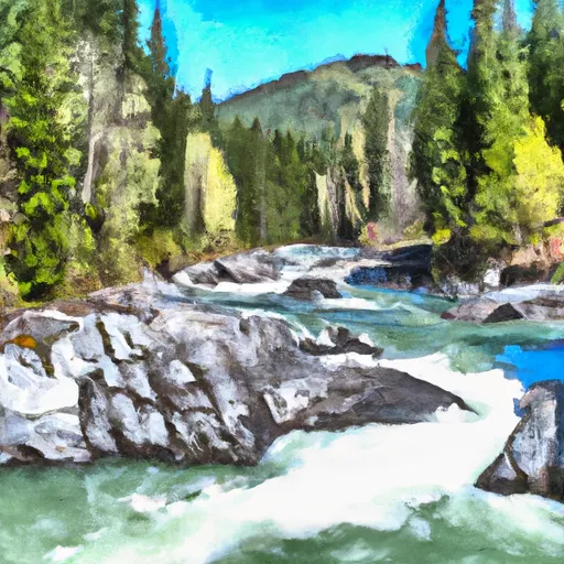
The Selway River run starts at Section 10, T32N, R12E, and ends at the Headwaters All Forks. The entire run covers a distance of approximately 47 miles, with a segment mileage of 30 miles. The river is known for its scenic beauty, with lush forests and rugged mountain terrain.
The Selway River has several rapids and obstacles that add to the excitement of the run. The most notable rapids include Moose Creek, Ladle and Double Drop, and the infamous Goat Creek. These rapids range from class III to class IV, with Goat Creek being the most challenging.
To ensure the safety of all visitors, the Selway River is subject to specific regulations. Permits are required to run the river, and the number of permits is limited to protect the environment. Visitors must also abide by the strict leave-no-trace policy, which requires them to pack out all trash and minimize their impact on the environment.
In conclusion, the Selway River is an exciting whitewater river run that offers a challenging experience for experienced rafters and kayakers. With an ideal streamflow range of 1,000 to 5,000 cfs, a class rating of III-IV, and several rapids and obstacles, the Selway River is a must-visit destination for any whitewater enthusiast. However, visitors must adhere to specific regulations to protect the environment and ensure the safety of all visitors.
Plan your run down to the hour
Same weather feed Snoflo's iOS app uses -- updated continuously from NOAA / yr.no. Watch the precipitation column on the meteogram; rain ahead of a run typically lifts flows 12-48 hours later depending on the basin.
Next 5 days, hour by hour
Temperature line with weather symbols on top, snow + rain accumulation as columns, humidity as a dotted line.
5-day forecast table
Every 3 hours, broken out across temperature, snow, rain, humidity, and wind. Each cell is colour-coded relative to the column min/max.
| Time | Condition | Temp (°F) | Snow (in) | Rain (in) | Humidity (%) | Wind (mps) | Wind dir |
|---|---|---|---|---|---|---|---|
| Loading detailed forecast… | |||||||
15-day temperature & precipitation
Daily temperatures, snow, and rain projected over the next two weeks -- the upstream story that drives next week's flows.
Regional streamflow levels
USGS streamgauges around Selway River, Sec. 10, T32n, R12e To Headwaters All Forks -- useful for spotting upstream pulses and gauging which tributary is contributing what.
| Streamgauge | Discharge | View |
|---|---|---|
| Selway River Nr Lowell Id | 1,320 cfs | → |
| Lochsa River Nr Lowell Id | 971 cfs | → |
| Sf Clearwater River Nr Elk City Id | 42 cfs | → |
| Bitterroot River Near Darby Mt | 430 cfs | → |
| West Fork Bitterroot River Nr Conner Mt | 143 cfs | → |
| Bitterroot River At Bell Crossing Nr Victor Mt | 350 cfs | → |
Plan a longer trip
The closest boat launches, other paddle runs, and campgrounds so a day on the water can grow into a full weekend.
Other river runs
- Selway River, Sec. 22, T32n, R11e To Headwaters
- 32nd Street To Smelter
- Selway River, Sec. 16, T31n, R13e To Headwaters
- Headwaters (Sec 5, T32n, R10e) To Selway-Bitterroot Wilderness Boundary
- Sec. 28, T30n, R13e To Boundary Selway-Bitterroot Wilderness
Campgrounds
Whitewater safety
- Check the flow before you run
- Use the linked-gauge card and Regional Flow panel above. Class ratings change with flow -- a Class III at low water can become Class IV+ at high water.
- Know your skill ceiling
- Pick runs comfortably below your ceiling. Cold-water and big-water runs raise the consequences of any mistake.
- Wear the right gear
- Helmet, PFD, drysuit / wetsuit when water is below 60°F. Throw bag, knife, and whistle on your person, not in the boat.
- Scout, set safety, and run with a team
- Scout new rapids on foot, set safety with throw bags above the consequence pool, and run with at least one other competent paddler.
- Respect the river
- Strainers, undercuts, low-head dams, and wood can kill at any class rating. When in doubt, portage.
Set push alerts in the Snoflo app
Save Selway River, Sec. 10, T32n, R12e To Headwaters All Forks as a favorite, set a discharge threshold (e.g. "alert me when flow hits 600 cfs"), and the iOS app pushes the moment the linked gauge crosses.
About Selway River, Sec. 10, T32n, R12e To Headwaters All Forks
What's the optimal flow for Selway River, Sec. 10, T32n, R12e To Headwaters All Forks?
The optimal flow depends on the section and the craft. Check the Run Details panel for the linked gauge and current status.
How fresh is the cfs reading on this page?
The linked USGS streamgauge reports continuously (every 15 minutes); Snoflo refreshes throughout the day. Hover the streamflow sparkline to read individual datapoints.
What's the whitewater class?
See the Run Details panel for the class rating Snoflo tracks for this run. Class ratings change with flow -- a Class III at low water can become Class IV in high water.
Where do I put in / take out?
Tap Directions in the hero above to open driving directions to the put-in. For shuttle planning, check the Nearby Boat Launches panel and the river run operator's site.
Can I get alerts when flows hit the optimal range?
Yes -- alerts are managed in the Snoflo iOS app. Favorite this run, set a discharge threshold, and you'll get a push the moment the gauge crosses.
Other runs near here
Snoflo-tracked paddle runs within driving distance of Selway River, Sec. 10, T32n, R12e To Headwaters All Forks.