Selway River, Sec. 22, T32n, R11e To Headwaters River Run
Community Reviews
Been here? Share the conditions.
Reviews, ratings & photos are added in the free Snoflo iOS app — rate a spot, tag the conditions, and your visit is verified by location. Add or manage your reviews from the app.
Selway River, Sec. 22, T32n, R11e To Headwaters
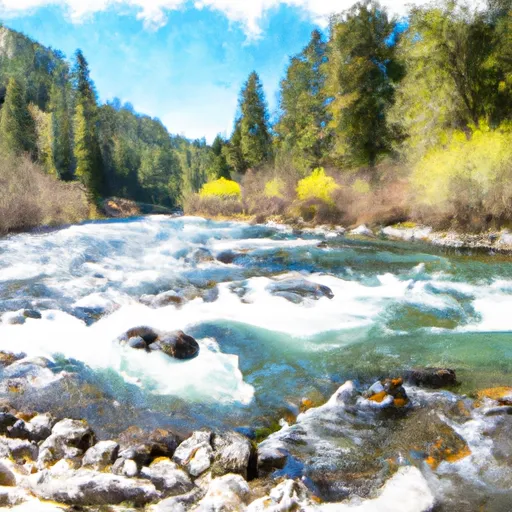
The river run covers a segment of approximately 47 miles, starting at Sec. 22, T32N, R11E and ending at the headwaters. Some of the notable rapids and obstacles on the Selway River include Moose Creek Rapid, Ladle Rapid, and Double Drop Rapid. These rapids require a high level of skill and experience to navigate safely.
To protect the natural beauty and resources of the Selway River, there are specific regulations in place for the area. A permit is required to float the Selway River, with a limited number of permits available each year. Additionally, campfires are prohibited along the river, and all human waste must be carried out.
In conclusion, the Selway River is a challenging and scenic whitewater river run in Idaho. The ideal streamflow range is between 1,200 and 3,000 cfs, and the river is classified as Class IV-V. The segment covers approximately 47 miles and includes challenging rapids and obstacles. Specific regulations are in place to protect the natural resources of the area, including the need for a permit and restrictions on campfires and human waste.
Plan your run down to the hour
Same weather feed Snoflo's iOS app uses -- updated continuously from NOAA / yr.no. Watch the precipitation column on the meteogram; rain ahead of a run typically lifts flows 12-48 hours later depending on the basin.
Next 5 days, hour by hour
Temperature line with weather symbols on top, snow + rain accumulation as columns, humidity as a dotted line.
5-day forecast table
Every 3 hours, broken out across temperature, snow, rain, humidity, and wind. Each cell is colour-coded relative to the column min/max.
| Time | Condition | Temp (°F) | Snow (in) | Rain (in) | Humidity (%) | Wind (mps) | Wind dir |
|---|---|---|---|---|---|---|---|
| Loading detailed forecast… | |||||||
15-day temperature & precipitation
Daily temperatures, snow, and rain projected over the next two weeks -- the upstream story that drives next week's flows.
Regional streamflow levels
USGS streamgauges around Selway River, Sec. 22, T32n, R11e To Headwaters -- useful for spotting upstream pulses and gauging which tributary is contributing what.
| Streamgauge | Discharge | View |
|---|---|---|
| Selway River Nr Lowell Id | 1,030 cfs | → |
| Lochsa River Nr Lowell Id | 766 cfs | → |
| Sf Clearwater River Nr Elk City Id | 42 cfs | → |
| Clear Ck At Kooskia National Fish Hatchery | 18 cfs | → |
| Sf Clearwater River At Stites Id | 172 cfs | → |
| Bitterroot River Near Darby Mt | 402 cfs | → |
Plan a longer trip
The closest boat launches, other paddle runs, and campgrounds so a day on the water can grow into a full weekend.
Other river runs
- Selway River, Sec. 10, T32n, R12e To Headwaters All Forks
- Headwaters (Sec 5, T32n, R10e) To Selway-Bitterroot Wilderness Boundary
- Selway-Bitterroot Wilderness Boundary, Sec. 35, T33n, R9e To Headwaters, Sec. 33, T33n, R10e
- Selway River, Sec. 11, T31n, R9e To Road Crossing, Sec. 14, T31n, R9e
- Road Crossing, Sec. 14, T31n, R9e To Headwaters
Campgrounds
Whitewater safety
- Check the flow before you run
- Use the linked-gauge card and Regional Flow panel above. Class ratings change with flow -- a Class III at low water can become Class IV+ at high water.
- Know your skill ceiling
- Pick runs comfortably below your ceiling. Cold-water and big-water runs raise the consequences of any mistake.
- Wear the right gear
- Helmet, PFD, drysuit / wetsuit when water is below 60°F. Throw bag, knife, and whistle on your person, not in the boat.
- Scout, set safety, and run with a team
- Scout new rapids on foot, set safety with throw bags above the consequence pool, and run with at least one other competent paddler.
- Respect the river
- Strainers, undercuts, low-head dams, and wood can kill at any class rating. When in doubt, portage.
Set push alerts in the Snoflo app
Save Selway River, Sec. 22, T32n, R11e To Headwaters as a favorite, set a discharge threshold (e.g. "alert me when flow hits 600 cfs"), and the iOS app pushes the moment the linked gauge crosses.
About Selway River, Sec. 22, T32n, R11e To Headwaters
What's the optimal flow for Selway River, Sec. 22, T32n, R11e To Headwaters?
The optimal flow depends on the section and the craft. Check the Run Details panel for the linked gauge and current status.
How fresh is the cfs reading on this page?
The linked USGS streamgauge reports continuously (every 15 minutes); Snoflo refreshes throughout the day. Hover the streamflow sparkline to read individual datapoints.
What's the whitewater class?
See the Run Details panel for the class rating Snoflo tracks for this run. Class ratings change with flow -- a Class III at low water can become Class IV in high water.
Where do I put in / take out?
Tap Directions in the hero above to open driving directions to the put-in. For shuttle planning, check the Nearby Boat Launches panel and the river run operator's site.
Can I get alerts when flows hit the optimal range?
Yes -- alerts are managed in the Snoflo iOS app. Favorite this run, set a discharge threshold, and you'll get a push the moment the gauge crosses.
Other runs near here
Snoflo-tracked paddle runs within driving distance of Selway River, Sec. 22, T32n, R11e To Headwaters.