Salmon River River Run
Community Reviews
Been here? Share the conditions.
Reviews, ratings & photos are added in the free Snoflo iOS app — rate a spot, tag the conditions, and your visit is verified by location. Add or manage your reviews from the app.
Salmon River
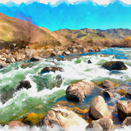
The Salmon River stretches over 425 miles through the state, but the most popular segment for whitewater rafting is the Middle Fork, which covers 100 miles and has rapids ranging from Class II to Class IV. Some of the most notable rapids on the Middle Fork include Velvet Falls, Lake Creek, and Marble Creek. These rapids offer exciting challenges for experienced paddlers.
Specific regulations in the area include a permit system for river use, as well as strict rules for camping and waste disposal. The Salmon River is managed by the Bureau of Land Management and the Forest Service, and they require visitors to follow Leave No Trace principles, which forbid littering, damaging vegetation, or leaving anything behind.
Overall, the Salmon River is an excellent destination for whitewater rafting enthusiasts. With its ideal streamflow range, Class III-IV rating, and challenging rapids, it offers a thrilling adventure experience. However, visitors should be mindful of specific regulations in the area to protect and preserve the river and its surroundings.
Plan your run down to the hour
Same weather feed Snoflo's iOS app uses -- updated continuously from NOAA / yr.no. Watch the precipitation column on the meteogram; rain ahead of a run typically lifts flows 12-48 hours later depending on the basin.
Next 5 days, hour by hour
Temperature line with weather symbols on top, snow + rain accumulation as columns, humidity as a dotted line.
5-day forecast table
Every 3 hours, broken out across temperature, snow, rain, humidity, and wind. Each cell is colour-coded relative to the column min/max.
| Time | Condition | Temp (°F) | Snow (in) | Rain (in) | Humidity (%) | Wind (mps) | Wind dir |
|---|---|---|---|---|---|---|---|
| Loading detailed forecast… | |||||||
15-day temperature & precipitation
Daily temperatures, snow, and rain projected over the next two weeks -- the upstream story that drives next week's flows.
Regional streamflow levels
USGS streamgauges around Salmon River -- useful for spotting upstream pulses and gauging which tributary is contributing what.
| Streamgauge | Discharge | View |
|---|---|---|
| Salmon River At White Bird Id | 6,570 cfs | → |
| Little Salmon River At Riggins Id | 260 cfs | → |
| Sf Clearwater River At Stites Id | 284 cfs | → |
| Imnaha River At Imnaha | 150 cfs | → |
| Clear Ck At Kooskia National Fish Hatchery | 18 cfs | → |
| Snake River Bl Mcduff Rapids At China Gardens | 15,700 cfs | → |
Plan a longer trip
The closest boat launches, other paddle runs, and campgrounds so a day on the water can grow into a full weekend.
Boat launches
- Hammer Creek
- Campbell Flat
- Twin Bridges
- Us 95 Idaho County
- Center Creek Road Idaho County
- Pittsburg Landing Road Idaho County
Other river runs
- Hammer Creek To Heller Bar (Lower Salmon)
- Salmon River, Sec. 22, T28n, R1e To North And South Forks Of White Bird Creek
- Salmon River, Sec. 36, T27n, R1e To Gospel-Hump Wilderness Boundary, Sec. 31, T27n, R4e
- Pittsburg Landing To Heller Bar
- Wilderness Boundary To Headwaters
Whitewater safety
- Check the flow before you run
- Use the linked-gauge card and Regional Flow panel above. Class ratings change with flow -- a Class III at low water can become Class IV+ at high water.
- Know your skill ceiling
- Pick runs comfortably below your ceiling. Cold-water and big-water runs raise the consequences of any mistake.
- Wear the right gear
- Helmet, PFD, drysuit / wetsuit when water is below 60°F. Throw bag, knife, and whistle on your person, not in the boat.
- Scout, set safety, and run with a team
- Scout new rapids on foot, set safety with throw bags above the consequence pool, and run with at least one other competent paddler.
- Respect the river
- Strainers, undercuts, low-head dams, and wood can kill at any class rating. When in doubt, portage.
Set push alerts in the Snoflo app
Save Salmon River as a favorite, set a discharge threshold (e.g. "alert me when flow hits 600 cfs"), and the iOS app pushes the moment the linked gauge crosses.
About Salmon River
What's the optimal flow for Salmon River?
The optimal flow depends on the section and the craft. Check the Run Details panel for the linked gauge and current status.
How fresh is the cfs reading on this page?
The linked USGS streamgauge reports continuously (every 15 minutes); Snoflo refreshes throughout the day. Hover the streamflow sparkline to read individual datapoints.
What's the whitewater class?
See the Run Details panel for the class rating Snoflo tracks for this run. Class ratings change with flow -- a Class III at low water can become Class IV in high water.
Where do I put in / take out?
Tap Directions in the hero above to open driving directions to the put-in. For shuttle planning, check the Nearby Boat Launches panel and the river run operator's site.
Can I get alerts when flows hit the optimal range?
Yes -- alerts are managed in the Snoflo iOS app. Favorite this run, set a discharge threshold, and you'll get a push the moment the gauge crosses.
Other runs near here
Snoflo-tracked paddle runs within driving distance of Salmon River.