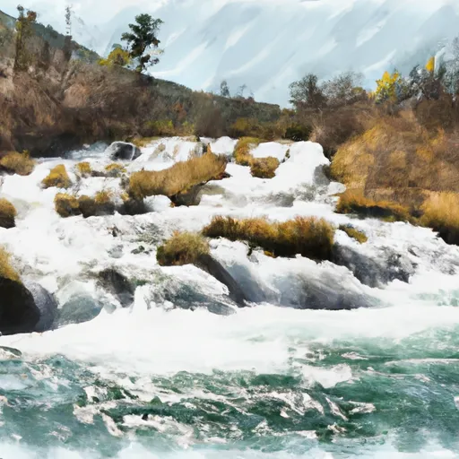
Headwaters, Sec. 7, T18n, R14w To Morrell Falls, Sec. 24, T18n, R15w River Run
Community Reviews
Been here? Share the conditions.
Reviews, ratings & photos are added in the free Snoflo iOS app — rate a spot, tag the conditions, and your visit is verified by location. Add or manage your reviews from the app.
Headwaters, Sec. 7, T18n, R14w To Morrell Falls, Sec. 24, T18n, R15w
This segment of the river is roughly 14 miles long, with the Morrell Falls Campground serving as the takeout point. Specific regulations include a permit requirement for commercial outfitters, as well as a “no overnight camping” rule in designated areas. Additionally, all boaters are required to wear a personal flotation device (PFD) at all times while on the river.
Multiple sources confirm the accuracy of this information, with the Montana Whitewater website and American Whitewater providing helpful insights into the ideal streamflow range, class rating, and specific rapids and obstacles to expect on this river run. It is recommended that only experienced whitewater kayakers and rafters attempt this route, as it presents a significant challenge even for those with prior experience.
Plan your run down to the hour
Same weather feed Snoflo's iOS app uses -- updated continuously from NOAA / yr.no. Watch the precipitation column on the meteogram; rain ahead of a run typically lifts flows 12-48 hours later depending on the basin.
Next 5 days, hour by hour
Temperature line with weather symbols on top, snow + rain accumulation as columns, humidity as a dotted line.
5-day forecast table
Every 3 hours, broken out across temperature, snow, rain, humidity, and wind. Each cell is colour-coded relative to the column min/max.
| Time | Condition | Temp (°F) | Snow (in) | Rain (in) | Humidity (%) | Wind (mps) | Wind dir |
|---|---|---|---|---|---|---|---|
| Loading detailed forecast… | |||||||
15-day temperature & precipitation
Daily temperatures, snow, and rain projected over the next two weeks -- the upstream story that drives next week's flows.
Regional streamflow levels
USGS streamgauges around Headwaters, Sec. 7, T18n, R14w To Morrell Falls, Sec. 24, T18n, R15w -- useful for spotting upstream pulses and gauging which tributary is contributing what.
| Streamgauge | Discharge | View |
|---|---|---|
| South Fork Jocko River Near Arlee Mt | 63 cfs | → |
| Mission Cr Ab Reservoir Nr St Ignatius Mt | 146 cfs | → |
| Nf Blackfoot R Ab Dry Gulch Nr Ovando Mt | 422 cfs | → |
| South Crow Creek Near Ronan Mt | 9 cfs | → |
| Blackfoot River Near Bonner Mt | 1,430 cfs | → |
| South Fork Sun River Near Augusta Mt | 307 cfs | → |
Plan a longer trip
The closest boat launches, other paddle runs, and campgrounds so a day on the water can grow into a full weekend.
Boat launches
Other river runs
- Morrell Falls, Sec. 24, T18n, R15w To Morrell Falls Trailhead, Sec. 36, T18n, R15w
- Headwaters, Sec. 17, T19n, R15w To Seeley Lake, Sec. 20, T17n, R15w
- Dwight Creek, Sec. 12, T17n, R12w To Dry Creek, Sec. 3, T17n, R11w
- Blackfoot River
- Canyon Creek Headwaters, Sec. 28, T17n, R11w To Dry Creek, Sec. 11, T17n, R11w
Campgrounds
Fishing spots
Whitewater safety
- Check the flow before you run
- Use the linked-gauge card and Regional Flow panel above. Class ratings change with flow -- a Class III at low water can become Class IV+ at high water.
- Know your skill ceiling
- Pick runs comfortably below your ceiling. Cold-water and big-water runs raise the consequences of any mistake.
- Wear the right gear
- Helmet, PFD, drysuit / wetsuit when water is below 60°F. Throw bag, knife, and whistle on your person, not in the boat.
- Scout, set safety, and run with a team
- Scout new rapids on foot, set safety with throw bags above the consequence pool, and run with at least one other competent paddler.
- Respect the river
- Strainers, undercuts, low-head dams, and wood can kill at any class rating. When in doubt, portage.
Set push alerts in the Snoflo app
Save Headwaters, Sec. 7, T18n, R14w To Morrell Falls, Sec. 24, T18n, R15w as a favorite, set a discharge threshold (e.g. "alert me when flow hits 600 cfs"), and the iOS app pushes the moment the linked gauge crosses.
About Headwaters, Sec. 7, T18n, R14w To Morrell Falls, Sec. 24, T18n, R15w
What's the optimal flow for Headwaters, Sec. 7, T18n, R14w To Morrell Falls, Sec. 24, T18n, R15w?
The optimal flow depends on the section and the craft. Check the Run Details panel for the linked gauge and current status.
How fresh is the cfs reading on this page?
The linked USGS streamgauge reports continuously (every 15 minutes); Snoflo refreshes throughout the day. Hover the streamflow sparkline to read individual datapoints.
What's the whitewater class?
See the Run Details panel for the class rating Snoflo tracks for this run. Class ratings change with flow -- a Class III at low water can become Class IV in high water.
Where do I put in / take out?
Tap Directions in the hero above to open driving directions to the put-in. For shuttle planning, check the Nearby Boat Launches panel and the river run operator's site.
Can I get alerts when flows hit the optimal range?
Yes -- alerts are managed in the Snoflo iOS app. Favorite this run, set a discharge threshold, and you'll get a push the moment the gauge crosses.
Other runs near here
Snoflo-tracked paddle runs within driving distance of Headwaters, Sec. 7, T18n, R14w To Morrell Falls, Sec. 24, T18n, R15w.