Fool Creek, Sec. 24, T25n, R11w To Wilderness Boundary River Run
Community Reviews
Been here? Share the conditions.
Reviews, ratings & photos are added in the free Snoflo iOS app — rate a spot, tag the conditions, and your visit is verified by location. Add or manage your reviews from the app.
Fool Creek, Sec. 24, T25n, R11w To Wilderness Boundary
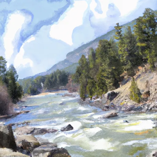
This river has been classified as a Class III river run, which means it has moderate rapids with irregular waves and narrow channels. Fool Creek features several challenging rapids and obstacles, including the S-Turn Rapid, the Notch, and the Gorge.
As for regulations, it is important to note that Fool Creek is located within the Bob Marshall Wilderness Area and therefore has specific regulations. A permit is required for all overnight camping, and all visitors must follow strict Leave No Trace ethics. Additionally, motorized vehicles are prohibited in the area.
In conclusion, Fool Creek is a challenging river run with Class III rapids and several unique obstacles. The ideal streamflow range is between 200 to 800 cfs, and the segment mileage is approximately 4.5 miles. Visitors must follow specific regulations, including obtaining a permit for overnight camping and adhering to Leave No Trace ethics.
Plan your run down to the hour
Same weather feed Snoflo's iOS app uses -- updated continuously from NOAA / yr.no. Watch the precipitation column on the meteogram; rain ahead of a run typically lifts flows 12-48 hours later depending on the basin.
Next 5 days, hour by hour
Temperature line with weather symbols on top, snow + rain accumulation as columns, humidity as a dotted line.
5-day forecast table
Every 3 hours, broken out across temperature, snow, rain, humidity, and wind. Each cell is colour-coded relative to the column min/max.
| Time | Condition | Temp (°F) | Snow (in) | Rain (in) | Humidity (%) | Wind (mps) | Wind dir |
|---|---|---|---|---|---|---|---|
| Loading detailed forecast… | |||||||
15-day temperature & precipitation
Daily temperatures, snow, and rain projected over the next two weeks -- the upstream story that drives next week's flows.
Regional streamflow levels
USGS streamgauges around Fool Creek, Sec. 24, T25n, R11w To Wilderness Boundary -- useful for spotting upstream pulses and gauging which tributary is contributing what.
| Streamgauge | Discharge | View |
|---|---|---|
| North Fork Sun River Near Augusta Mt | 252 cfs | → |
| South Fork Sun River Near Augusta Mt | 246 cfs | → |
| Sun River Bl Diversion Dam Nr Augusta Mt | 107 cfs | → |
| Teton River Bl South Fork Nr Choteau Mt | 155 cfs | → |
| Sun River Bl Willow Cr Nr Augusta Mt | 247 cfs | → |
| S F Flathead R Ab Twin C Nr Hungry Horse Mt | 1,530 cfs | → |
Plan a longer trip
The closest boat launches, other paddle runs, and campgrounds so a day on the water can grow into a full weekend.
Other river runs
- Headwaters, Sec. 4, T18n, R10w To North Fork Sun River, Sec. 26, T22n, R10w
- Wilderness Boundary To South Fork Sun River, Sec. 26, T22n, R10w
- Headwaters, Sec. 15, T18n, R10w To Straight Creek, Sec. 25, T19n, R10w
- Dobrota Headwaters, Sec. 23, T18n, R10w To Mainstem, Sec. 31, T18n, R9w
- Cooney Cr Headwaters, Sec. 17, T19n, R9w To Mainstem, Sec. 1, T17n, R10w
Whitewater safety
- Check the flow before you run
- Use the linked-gauge card and Regional Flow panel above. Class ratings change with flow -- a Class III at low water can become Class IV+ at high water.
- Know your skill ceiling
- Pick runs comfortably below your ceiling. Cold-water and big-water runs raise the consequences of any mistake.
- Wear the right gear
- Helmet, PFD, drysuit / wetsuit when water is below 60°F. Throw bag, knife, and whistle on your person, not in the boat.
- Scout, set safety, and run with a team
- Scout new rapids on foot, set safety with throw bags above the consequence pool, and run with at least one other competent paddler.
- Respect the river
- Strainers, undercuts, low-head dams, and wood can kill at any class rating. When in doubt, portage.
Set push alerts in the Snoflo app
Save Fool Creek, Sec. 24, T25n, R11w To Wilderness Boundary as a favorite, set a discharge threshold (e.g. "alert me when flow hits 600 cfs"), and the iOS app pushes the moment the linked gauge crosses.
About Fool Creek, Sec. 24, T25n, R11w To Wilderness Boundary
What's the optimal flow for Fool Creek, Sec. 24, T25n, R11w To Wilderness Boundary?
The optimal flow depends on the section and the craft. Check the Run Details panel for the linked gauge and current status.
How fresh is the cfs reading on this page?
The linked USGS streamgauge reports continuously (every 15 minutes); Snoflo refreshes throughout the day. Hover the streamflow sparkline to read individual datapoints.
What's the whitewater class?
See the Run Details panel for the class rating Snoflo tracks for this run. Class ratings change with flow -- a Class III at low water can become Class IV in high water.
Where do I put in / take out?
Tap Directions in the hero above to open driving directions to the put-in. For shuttle planning, check the Nearby Boat Launches panel and the river run operator's site.
Can I get alerts when flows hit the optimal range?
Yes -- alerts are managed in the Snoflo iOS app. Favorite this run, set a discharge threshold, and you'll get a push the moment the gauge crosses.
Other runs near here
Snoflo-tracked paddle runs within driving distance of Fool Creek, Sec. 24, T25n, R11w To Wilderness Boundary.