East Prong From Sr 1100 To Confluence With Brice Creek River Run
Community Reviews
Been here? Share the conditions.
Reviews, ratings & photos are added in the free Snoflo iOS app — rate a spot, tag the conditions, and your visit is verified by location. Add or manage your reviews from the app.
East Prong From Sr 1100 To Confluence With Brice Creek
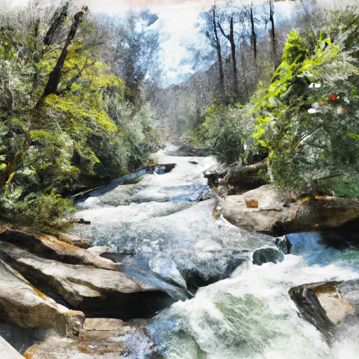
Paddlers are advised to use caution when navigating the East Prong, as the river is known for its powerful currents and technical rapids. In addition, paddlers must follow specific regulations in the area, including obtaining a permit from the U.S. Forest Service before using the river. Paddlers must also adhere to strict leave-no-trace principles and avoid disturbing the natural environment.
Overall, the East Prong of the Whitewater River offers an exciting whitewater experience for experienced paddlers. With its challenging rapids and stunning scenery, this segment is a must-visit for anyone looking for an adrenaline-packed adventure in North Carolina.
Plan your run down to the hour
Same weather feed Snoflo's iOS app uses -- updated continuously from NOAA / yr.no. Watch the precipitation column on the meteogram; rain ahead of a run typically lifts flows 12-48 hours later depending on the basin.
Next 5 days, hour by hour
Temperature line with weather symbols on top, snow + rain accumulation as columns, humidity as a dotted line.
5-day forecast table
Every 3 hours, broken out across temperature, snow, rain, humidity, and wind. Each cell is colour-coded relative to the column min/max.
| Time | Condition | Temp (°F) | Snow (in) | Rain (in) | Humidity (%) | Wind (mps) | Wind dir |
|---|---|---|---|---|---|---|---|
| Loading detailed forecast… | |||||||
15-day temperature & precipitation
Daily temperatures, snow, and rain projected over the next two weeks -- the upstream story that drives next week's flows.
Regional streamflow levels
USGS streamgauges around East Prong From Sr 1100 To Confluence With Brice Creek -- useful for spotting upstream pulses and gauging which tributary is contributing what.
| Streamgauge | Discharge | View |
|---|---|---|
| Trent River Near Trenton | 7 cfs | → |
| Neuse River Near Fort Barnwell | 2,930 cfs | → |
| New River Near Gum Branch | 9 cfs | → |
| Neuse River At Kinston | 2,650 cfs | → |
| Chicod Cr At Sr1760 Near Simpson | 2 cfs | → |
| Contentnea Creek At Hookerton | 181 cfs | → |
Plan a longer trip
The closest boat launches, other paddle runs, and campgrounds so a day on the water can grow into a full weekend.
Boat launches
- Slocum Creek
- Brices Creek
- Great Lake
- Hancock Creek
- Jack's Island @ Lawson Creek Park
- Union Point Boat Ramp
Other river runs
- Fs Road 121-2 To Confluence With Brice Creek
- West Prong From Sr 1100 To Fs Road 121-2
- Brice Creek From Confluence With East/West Prongs To Nf Boundary Past Brice Creek Boat Ramp
- Nf Boundary To Confluence With Trent River
- 1.25 Miles Upstream From Hwy 17 Bridge To Black Swamp Creek
Campgrounds
- Fisher Landing
- Flanners Beach/Neuse River Campground
- Don Lee Camp & Retreat Center
- New Bern Koa
- Long Point Camping
- Camp Sam Hatcher
Whitewater safety
- Check the flow before you run
- Use the linked-gauge card and Regional Flow panel above. Class ratings change with flow -- a Class III at low water can become Class IV+ at high water.
- Know your skill ceiling
- Pick runs comfortably below your ceiling. Cold-water and big-water runs raise the consequences of any mistake.
- Wear the right gear
- Helmet, PFD, drysuit / wetsuit when water is below 60°F. Throw bag, knife, and whistle on your person, not in the boat.
- Scout, set safety, and run with a team
- Scout new rapids on foot, set safety with throw bags above the consequence pool, and run with at least one other competent paddler.
- Respect the river
- Strainers, undercuts, low-head dams, and wood can kill at any class rating. When in doubt, portage.
Set push alerts in the Snoflo app
Save East Prong From Sr 1100 To Confluence With Brice Creek as a favorite, set a discharge threshold (e.g. "alert me when flow hits 600 cfs"), and the iOS app pushes the moment the linked gauge crosses.
About East Prong From Sr 1100 To Confluence With Brice Creek
What's the optimal flow for East Prong From Sr 1100 To Confluence With Brice Creek?
The optimal flow depends on the section and the craft. Check the Run Details panel for the linked gauge and current status.
How fresh is the cfs reading on this page?
The linked USGS streamgauge reports continuously (every 15 minutes); Snoflo refreshes throughout the day. Hover the streamflow sparkline to read individual datapoints.
What's the whitewater class?
See the Run Details panel for the class rating Snoflo tracks for this run. Class ratings change with flow -- a Class III at low water can become Class IV in high water.
Where do I put in / take out?
Tap Directions in the hero above to open driving directions to the put-in. For shuttle planning, check the Nearby Boat Launches panel and the river run operator's site.
Can I get alerts when flows hit the optimal range?
Yes -- alerts are managed in the Snoflo iOS app. Favorite this run, set a discharge threshold, and you'll get a push the moment the gauge crosses.
Other runs near here
Snoflo-tracked paddle runs within driving distance of East Prong From Sr 1100 To Confluence With Brice Creek.