Headwaters To 1.24 River Miles Upstream From Us Hwy 17 Bridge River Run
Community Reviews
Been here? Share the conditions.
Reviews, ratings & photos are added in the free Snoflo iOS app — rate a spot, tag the conditions, and your visit is verified by location. Add or manage your reviews from the app.
Headwaters To 1.24 River Miles Upstream From Us Hwy 17 Bridge
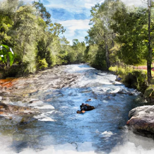
The specific river rapids and obstacles on this run include Boof or Consequence, which is a Class IV rapid with a steep drop and a tight turn. There is also Surprise, a Class III rapid with multiple rocks and a large wave at the bottom. The run also has several boulder gardens and narrow chutes that require precise maneuvering.
It is important to note that this section of the Whitewater River is governed by specific regulations, such as required life jackets and helmets, as well as a prohibition on alcohol consumption. Additionally, there are specific access points and parking areas designated for this section of the river. It is important for visitors to follow these regulations to ensure safety and preserve the natural beauty of the area.
Plan your run down to the hour
Same weather feed Snoflo's iOS app uses -- updated continuously from NOAA / yr.no. Watch the precipitation column on the meteogram; rain ahead of a run typically lifts flows 12-48 hours later depending on the basin.
Next 5 days, hour by hour
Temperature line with weather symbols on top, snow + rain accumulation as columns, humidity as a dotted line.
5-day forecast table
Every 3 hours, broken out across temperature, snow, rain, humidity, and wind. Each cell is colour-coded relative to the column min/max.
| Time | Condition | Temp (°F) | Snow (in) | Rain (in) | Humidity (%) | Wind (mps) | Wind dir |
|---|---|---|---|---|---|---|---|
| Loading detailed forecast… | |||||||
15-day temperature & precipitation
Daily temperatures, snow, and rain projected over the next two weeks -- the upstream story that drives next week's flows.
Regional streamflow levels
USGS streamgauges around Headwaters To 1.24 River Miles Upstream From Us Hwy 17 Bridge -- useful for spotting upstream pulses and gauging which tributary is contributing what.
| Streamgauge | Discharge | View |
|---|---|---|
| New River Near Gum Branch | 5 cfs | → |
| Trent River Near Trenton | 4 cfs | → |
| Neuse River Near Fort Barnwell | 3,560 cfs | → |
| Neuse River At Kinston | 3,560 cfs | → |
| Northeast Cape Fear River Near Chinquapin | 644 cfs | → |
| Bear Creek At Mays Store | 98 cfs | → |
Plan a longer trip
The closest boat launches, other paddle runs, and campgrounds so a day on the water can grow into a full weekend.
Boat launches
- Dixon Fields Canoe Launch
- Haywood Landing
- Pollocksville
- Long Point Road Jones County
- Great Lake
- Carteret County
Other river runs
- 1.25 Miles Upstream From Hwy 17 Bridge To Black Swamp Creek
- Black Swamp Creek To Nc Hwy 1442 Bridge At Stella
- West Prong From Sr 1100 To Fs Road 121-2
- East Prong From Sr 1100 To Confluence With Brice Creek
- Fs Road 121-2 To Confluence With Brice Creek
Campgrounds
- Long Point Camping
- Fisher Landing
- Hammocks Beach State Park
- Cedar Point
- Flanners Beach/Neuse River Campground
Whitewater safety
- Check the flow before you run
- Use the linked-gauge card and Regional Flow panel above. Class ratings change with flow -- a Class III at low water can become Class IV+ at high water.
- Know your skill ceiling
- Pick runs comfortably below your ceiling. Cold-water and big-water runs raise the consequences of any mistake.
- Wear the right gear
- Helmet, PFD, drysuit / wetsuit when water is below 60°F. Throw bag, knife, and whistle on your person, not in the boat.
- Scout, set safety, and run with a team
- Scout new rapids on foot, set safety with throw bags above the consequence pool, and run with at least one other competent paddler.
- Respect the river
- Strainers, undercuts, low-head dams, and wood can kill at any class rating. When in doubt, portage.
Set push alerts in the Snoflo app
Save Headwaters To 1.24 River Miles Upstream From Us Hwy 17 Bridge as a favorite, set a discharge threshold (e.g. "alert me when flow hits 600 cfs"), and the iOS app pushes the moment the linked gauge crosses.
About Headwaters To 1.24 River Miles Upstream From Us Hwy 17 Bridge
What's the optimal flow for Headwaters To 1.24 River Miles Upstream From Us Hwy 17 Bridge?
The optimal flow depends on the section and the craft. Check the Run Details panel for the linked gauge and current status.
How fresh is the cfs reading on this page?
The linked USGS streamgauge reports continuously (every 15 minutes); Snoflo refreshes throughout the day. Hover the streamflow sparkline to read individual datapoints.
What's the whitewater class?
See the Run Details panel for the class rating Snoflo tracks for this run. Class ratings change with flow -- a Class III at low water can become Class IV in high water.
Where do I put in / take out?
Tap Directions in the hero above to open driving directions to the put-in. For shuttle planning, check the Nearby Boat Launches panel and the river run operator's site.
Can I get alerts when flows hit the optimal range?
Yes -- alerts are managed in the Snoflo iOS app. Favorite this run, set a discharge threshold, and you'll get a push the moment the gauge crosses.
Other runs near here
Snoflo-tracked paddle runs within driving distance of Headwaters To 1.24 River Miles Upstream From Us Hwy 17 Bridge.