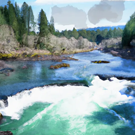
Below Cougar Dam To Confluence With Mckenzie River River Run
Community Reviews
Been here? Share the conditions.
Reviews, ratings & photos are added in the free Snoflo iOS app — rate a spot, tag the conditions, and your visit is verified by location. Add or manage your reviews from the app.
Below Cougar Dam To Confluence With Mckenzie River
There are specific rapids and obstacles that paddlers need to be aware of, including the Boulder Garden rapid, which has a large boulder field that requires careful navigation. The Rockpile rapid also has several large boulders that create challenging hydraulics. Another notable obstacle is the Pinball rapid, which has several large holes and waves that create a fun and challenging ride.
To ensure the safety of all paddlers, there are specific regulations in place for this area. All paddlers must wear a properly fitted personal flotation device (PFD) and a helmet at all times while on the water. Additionally, all boats must have a whistle and a throw rope. Paddlers must also adhere to Leave No Trace principles, pack out all trash, and avoid disturbing the natural environment.
Plan your run down to the hour
Same weather feed Snoflo's iOS app uses -- updated continuously from NOAA / yr.no. Watch the precipitation column on the meteogram; rain ahead of a run typically lifts flows 12-48 hours later depending on the basin.
Next 5 days, hour by hour
Temperature line with weather symbols on top, snow + rain accumulation as columns, humidity as a dotted line.
5-day forecast table
Every 3 hours, broken out across temperature, snow, rain, humidity, and wind. Each cell is colour-coded relative to the column min/max.
| Time | Condition | Temp (°F) | Snow (in) | Rain (in) | Humidity (%) | Wind (mps) | Wind dir |
|---|---|---|---|---|---|---|---|
| Loading detailed forecast… | |||||||
15-day temperature & precipitation
Daily temperatures, snow, and rain projected over the next two weeks -- the upstream story that drives next week's flows.
Regional streamflow levels
USGS streamgauges around Below Cougar Dam To Confluence With Mckenzie River -- useful for spotting upstream pulses and gauging which tributary is contributing what.
| Streamgauge | Discharge | View |
|---|---|---|
| Blue River At Blue River | 221 cfs | → |
| South Fork Mckenzie River Near Rainbow | 336 cfs | → |
| Lookout Creek Near Blue River | 14 cfs | → |
| So Fk Mckenzie River Abv Cougar Lake Nr Rainbow Or | 196 cfs | → |
| Mckenzie River Near Vida | 1,860 cfs | → |
| Mckenzie R Blw Trail Br Dam Nr Belknap Springs | 601 cfs | → |
Plan a longer trip
The closest boat launches, other paddle runs, and campgrounds so a day on the water can grow into a full weekend.
Boat launches
Other river runs
- Mckenzie River Seg A
- Three Sisters Wilderness Boundary To Cougar Reservoir
- South Fork Gate Creek
- Headwaters To Blue River Reservoir
- North Fork Gate Creek
Campgrounds
- Delta Campground
- Lookout Campground
- Mona Campground
- Mckenzie Bridge Campground
- Cougar Dispersed Camping
- Horse Creek Group Campground
Whitewater safety
- Check the flow before you run
- Use the linked-gauge card and Regional Flow panel above. Class ratings change with flow -- a Class III at low water can become Class IV+ at high water.
- Know your skill ceiling
- Pick runs comfortably below your ceiling. Cold-water and big-water runs raise the consequences of any mistake.
- Wear the right gear
- Helmet, PFD, drysuit / wetsuit when water is below 60°F. Throw bag, knife, and whistle on your person, not in the boat.
- Scout, set safety, and run with a team
- Scout new rapids on foot, set safety with throw bags above the consequence pool, and run with at least one other competent paddler.
- Respect the river
- Strainers, undercuts, low-head dams, and wood can kill at any class rating. When in doubt, portage.
Set push alerts in the Snoflo app
Save Below Cougar Dam To Confluence With Mckenzie River as a favorite, set a discharge threshold (e.g. "alert me when flow hits 600 cfs"), and the iOS app pushes the moment the linked gauge crosses.
About Below Cougar Dam To Confluence With Mckenzie River
What's the optimal flow for Below Cougar Dam To Confluence With Mckenzie River?
The optimal flow depends on the section and the craft. Check the Run Details panel for the linked gauge and current status.
How fresh is the cfs reading on this page?
The linked USGS streamgauge reports continuously (every 15 minutes); Snoflo refreshes throughout the day. Hover the streamflow sparkline to read individual datapoints.
What's the whitewater class?
See the Run Details panel for the class rating Snoflo tracks for this run. Class ratings change with flow -- a Class III at low water can become Class IV in high water.
Where do I put in / take out?
Tap Directions in the hero above to open driving directions to the put-in. For shuttle planning, check the Nearby Boat Launches panel and the river run operator's site.
Can I get alerts when flows hit the optimal range?
Yes -- alerts are managed in the Snoflo iOS app. Favorite this run, set a discharge threshold, and you'll get a push the moment the gauge crosses.
Other runs near here
Snoflo-tracked paddle runs within driving distance of Below Cougar Dam To Confluence With Mckenzie River.