Battle Axe Creek To Willamette Nf Boundary River Run
Community Reviews
Been here? Share the conditions.
Reviews, ratings & photos are added in the free Snoflo iOS app — rate a spot, tag the conditions, and your visit is verified by location. Add or manage your reviews from the app.
Battle Axe Creek To Willamette Nf Boundary
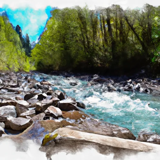
The segment covers a distance of 6.5 miles, with a variety of rapids and obstacles throughout. The first mile is characterized by steep drops and technical rapids, followed by a more mellow section before reaching the main attraction – a series of Class IV-V rapids known as the “Toilet Bowl” and “Gash.”
It is important to note that this section of the river is located within the Willamette National Forest and is subject to specific regulations. Visitors must obtain a Northwest Forest Pass to park at the Battle Axe Creek Trailhead and are required to pack out all trash and waste. Additionally, camping is only permitted in designated areas.
Overall, the Battle Axe Creek to Willamette National Forest Boundary section of the Whitewater River is a thrilling and scenic run for experienced paddlers, but caution should be taken and regulations followed to ensure a safe and respectful experience for all.
Plan your run down to the hour
Same weather feed Snoflo's iOS app uses -- updated continuously from NOAA / yr.no. Watch the precipitation column on the meteogram; rain ahead of a run typically lifts flows 12-48 hours later depending on the basin.
Next 5 days, hour by hour
Temperature line with weather symbols on top, snow + rain accumulation as columns, humidity as a dotted line.
5-day forecast table
Every 3 hours, broken out across temperature, snow, rain, humidity, and wind. Each cell is colour-coded relative to the column min/max.
| Time | Condition | Temp (°F) | Snow (in) | Rain (in) | Humidity (%) | Wind (mps) | Wind dir |
|---|---|---|---|---|---|---|---|
| Loading detailed forecast… | |||||||
15-day temperature & precipitation
Daily temperatures, snow, and rain projected over the next two weeks -- the upstream story that drives next week's flows.
Regional streamflow levels
USGS streamgauges around Battle Axe Creek To Willamette Nf Boundary -- useful for spotting upstream pulses and gauging which tributary is contributing what.
| Streamgauge | Discharge | View |
|---|---|---|
| North Santiam River At Niagara | 999 cfs | → |
| Bull Creek Near Wilhoit | 0 cfs | → |
| Little North Santiam River Near Mehama | 63 cfs | → |
| Breitenbush R Abv French Cr Nr Detroit | 116 cfs | → |
| North Santiam River At Mehama | 937 cfs | → |
| No Santiam R Blw Boulder Crk | 382 cfs | → |
Plan a longer trip
The closest boat launches, other paddle runs, and campgrounds so a day on the water can grow into a full weekend.
Boat launches
- Packsaddle Park
- 7th Street
- Big Cliff
- Fishermen's Bend Recreation Site
- Elk Lake Campgound
- Detroit Lake State Park - D Ramp
Other river runs
- Little North Santiam River
- Packsaddle County Park To Mill City
- North Santiam River
- Opal Lake To Confluence With Battle Axe Creek
- Confluence With North Fork Breitenbush River To Detroit Reservoir
Campgrounds
- Shady Cove Campground
- Elkhorn Valley Recreation Site
- Santiam Horse Camp
- Butte Creek Campground
- Fishermens Bend
- Fishermens Bend Recreation Site
Whitewater safety
- Check the flow before you run
- Use the linked-gauge card and Regional Flow panel above. Class ratings change with flow -- a Class III at low water can become Class IV+ at high water.
- Know your skill ceiling
- Pick runs comfortably below your ceiling. Cold-water and big-water runs raise the consequences of any mistake.
- Wear the right gear
- Helmet, PFD, drysuit / wetsuit when water is below 60°F. Throw bag, knife, and whistle on your person, not in the boat.
- Scout, set safety, and run with a team
- Scout new rapids on foot, set safety with throw bags above the consequence pool, and run with at least one other competent paddler.
- Respect the river
- Strainers, undercuts, low-head dams, and wood can kill at any class rating. When in doubt, portage.
Set push alerts in the Snoflo app
Save Battle Axe Creek To Willamette Nf Boundary as a favorite, set a discharge threshold (e.g. "alert me when flow hits 600 cfs"), and the iOS app pushes the moment the linked gauge crosses.
About Battle Axe Creek To Willamette Nf Boundary
What's the optimal flow for Battle Axe Creek To Willamette Nf Boundary?
The optimal flow depends on the section and the craft. Check the Run Details panel for the linked gauge and current status.
How fresh is the cfs reading on this page?
The linked USGS streamgauge reports continuously (every 15 minutes); Snoflo refreshes throughout the day. Hover the streamflow sparkline to read individual datapoints.
What's the whitewater class?
See the Run Details panel for the class rating Snoflo tracks for this run. Class ratings change with flow -- a Class III at low water can become Class IV in high water.
Where do I put in / take out?
Tap Directions in the hero above to open driving directions to the put-in. For shuttle planning, check the Nearby Boat Launches panel and the river run operator's site.
Can I get alerts when flows hit the optimal range?
Yes -- alerts are managed in the Snoflo iOS app. Favorite this run, set a discharge threshold, and you'll get a push the moment the gauge crosses.
Other runs near here
Snoflo-tracked paddle runs within driving distance of Battle Axe Creek To Willamette Nf Boundary.