Little Applegate River River Run
Community Reviews
Been here? Share the conditions.
Reviews, ratings & photos are added in the free Snoflo iOS app — rate a spot, tag the conditions, and your visit is verified by location. Add or manage your reviews from the app.
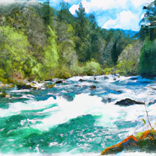
Little Applegate River
The Little Applegate River is rated as a Class III-IV river, with some challenging rapids and obstacles. The river is divided into two main segments: Upper and Lower Little Applegate. The Upper Little Applegate segment is approximately 7 miles long and offers challenging rapids such as "The Plunge" and "The Narrows". The Lower Little Applegate segment is approximately 12 miles long and offers more moderate rapids such as "Collins Riffle" and "Bottle Drop".
Specific river rapids and obstacles include boulder gardens, narrow chutes, steep drops, and technical rapids. Some of the most notable rapids include "The Plunge", a Class IV rapid with a steep drop and tight entrance, and "The Narrows", a Class III rapid with a narrow chute and tight walls.
There are specific regulations to the area, including a permit requirement for commercial outfitters and a limit of 10 commercial trips per day. All boaters are required to wear a personal flotation device and carry a whistle. Additionally, camping and fires are prohibited along the river corridor.
Plan your run down to the hour
Same weather feed Snoflo's iOS app uses -- updated continuously from NOAA / yr.no. Watch the precipitation column on the meteogram; rain ahead of a run typically lifts flows 12-48 hours later depending on the basin.
Next 5 days, hour by hour
Temperature line with weather symbols on top, snow + rain accumulation as columns, humidity as a dotted line.
5-day forecast table
Every 3 hours, broken out across temperature, snow, rain, humidity, and wind. Each cell is colour-coded relative to the column min/max.
| Time | Condition | Temp (°F) | Snow (in) | Rain (in) | Humidity (%) | Wind (mps) | Wind dir |
|---|---|---|---|---|---|---|---|
| Loading detailed forecast… | |||||||
15-day temperature & precipitation
Daily temperatures, snow, and rain projected over the next two weeks -- the upstream story that drives next week's flows.
Regional streamflow levels
USGS streamgauges around Little Applegate River -- useful for spotting upstream pulses and gauging which tributary is contributing what.
| Streamgauge | Discharge | View |
|---|---|---|
| West Fork Ashland Creek Near Ashland | 2 cfs | → |
| East Fork Ashland Creek Near Ashland | 1 cfs | → |
| Bear Creek Blw Ashland Creek At Ashland | 51 cfs | → |
| Star Gulch Near Ruch | 0 cfs | → |
| Applegate River Near Copper | 124 cfs | → |
| Bear Creek At Medford | 32 cfs | → |
Plan a longer trip
The closest boat launches, other paddle runs, and campgrounds so a day on the water can grow into a full weekend.
Boat launches
- Patrick Dunn
- Emigrant Lake West
- Emigrant Lake North
- Songer Wayside
- D. Gottville River Access
- C. Skeahan Bar River Access
Other river runs
Campgrounds
- Wrangle Campground
- Mt. Ashland Campground
- Mount Ashland Campground
- Mt Ashland
- Mount Ashland
- Beaver Creek Campground
Parks
Whitewater safety
- Check the flow before you run
- Use the linked-gauge card and Regional Flow panel above. Class ratings change with flow -- a Class III at low water can become Class IV+ at high water.
- Know your skill ceiling
- Pick runs comfortably below your ceiling. Cold-water and big-water runs raise the consequences of any mistake.
- Wear the right gear
- Helmet, PFD, drysuit / wetsuit when water is below 60°F. Throw bag, knife, and whistle on your person, not in the boat.
- Scout, set safety, and run with a team
- Scout new rapids on foot, set safety with throw bags above the consequence pool, and run with at least one other competent paddler.
- Respect the river
- Strainers, undercuts, low-head dams, and wood can kill at any class rating. When in doubt, portage.
Set push alerts in the Snoflo app
Save Little Applegate River as a favorite, set a discharge threshold (e.g. "alert me when flow hits 600 cfs"), and the iOS app pushes the moment the linked gauge crosses.
About Little Applegate River
What's the optimal flow for Little Applegate River?
The optimal flow depends on the section and the craft. Check the Run Details panel for the linked gauge and current status.
How fresh is the cfs reading on this page?
The linked USGS streamgauge reports continuously (every 15 minutes); Snoflo refreshes throughout the day. Hover the streamflow sparkline to read individual datapoints.
What's the whitewater class?
See the Run Details panel for the class rating Snoflo tracks for this run. Class ratings change with flow -- a Class III at low water can become Class IV in high water.
Where do I put in / take out?
Tap Directions in the hero above to open driving directions to the put-in. For shuttle planning, check the Nearby Boat Launches panel and the river run operator's site.
Can I get alerts when flows hit the optimal range?
Yes -- alerts are managed in the Snoflo iOS app. Favorite this run, set a discharge threshold, and you'll get a push the moment the gauge crosses.
Other runs near here
Snoflo-tracked paddle runs within driving distance of Little Applegate River.