Antelope Creek River Run
Community Reviews
Been here? Share the conditions.
Reviews, ratings & photos are added in the free Snoflo iOS app — rate a spot, tag the conditions, and your visit is verified by location. Add or manage your reviews from the app.
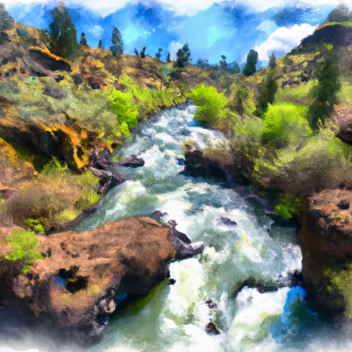
Antelope Creek
The class rating for Antelope Creek is Class III-IV, which means that the rapids are moderately difficult and require advanced paddling skills. This river run spans about 4.5 miles, with the most challenging section being the uppermost one.
There are several significant rapids and obstacles on Antelope Creek, including the "Muncher" and "Pinball" rapids. The "Muncher" rapid is a Class IV rapid that requires precise maneuvering through a narrow channel with a steep drop. The "Pinball" rapid is a Class III rapid that features multiple boulder obstacles that require careful navigation.
Specific regulations to the area include a permit requirement to launch a boat. Permits can be obtained through the Bureau of Land Management's Prineville District Office. Additionally, all boaters must comply with the "Leave No Trace" policy to preserve the natural environment and wildlife in the area.
Overall, Antelope Creek is a challenging and exciting river run for experienced paddlers looking for an adventure in the beautiful state of Oregon.
Plan your run down to the hour
Same weather feed Snoflo's iOS app uses -- updated continuously from NOAA / yr.no. Watch the precipitation column on the meteogram; rain ahead of a run typically lifts flows 12-48 hours later depending on the basin.
Next 5 days, hour by hour
Temperature line with weather symbols on top, snow + rain accumulation as columns, humidity as a dotted line.
5-day forecast table
Every 3 hours, broken out across temperature, snow, rain, humidity, and wind. Each cell is colour-coded relative to the column min/max.
| Time | Condition | Temp (°F) | Snow (in) | Rain (in) | Humidity (%) | Wind (mps) | Wind dir |
|---|---|---|---|---|---|---|---|
| Loading detailed forecast… | |||||||
15-day temperature & precipitation
Daily temperatures, snow, and rain projected over the next two weeks -- the upstream story that drives next week's flows.
Regional streamflow levels
USGS streamgauges around Antelope Creek -- useful for spotting upstream pulses and gauging which tributary is contributing what.
| Streamgauge | Discharge | View |
|---|---|---|
| Bear Creek Blw Ashland Creek At Ashland | 50 cfs | → |
| East Fork Ashland Creek Near Ashland | 1 cfs | → |
| West Fork Ashland Creek Near Ashland | 2 cfs | → |
| Bear Creek At Medford | 32 cfs | → |
| Rogue River At Dodge Bridge | 1,540 cfs | → |
| Rogue River At Raygold Near Central Point | 1,410 cfs | → |
Plan a longer trip
The closest boat launches, other paddle runs, and campgrounds so a day on the water can grow into a full weekend.
Boat launches
- Grizzly Creek
- Emigrant Lake North
- Emigrant Lake West
- Howard Prairie Resort
- Hyatt Lake Resort
- Wildcat Campground
Other river runs
- South Fork Little Butte Creek
- Big Butte Creek (Incl South Fork Big Butte Creek)
- Little Applegate River
- Gold Ray Dam To Grants Pass
- Left Fork Foots Creek
Campgrounds
- Willow-Witt Ranch
- Lily Glen - Howard Prairie Lake
- Grizzly - Howard Prairie Lake
- Jackson Wellsprings
- The Point Rv Campground
- Oak Slope Campground
Parks
Whitewater safety
- Check the flow before you run
- Use the linked-gauge card and Regional Flow panel above. Class ratings change with flow -- a Class III at low water can become Class IV+ at high water.
- Know your skill ceiling
- Pick runs comfortably below your ceiling. Cold-water and big-water runs raise the consequences of any mistake.
- Wear the right gear
- Helmet, PFD, drysuit / wetsuit when water is below 60°F. Throw bag, knife, and whistle on your person, not in the boat.
- Scout, set safety, and run with a team
- Scout new rapids on foot, set safety with throw bags above the consequence pool, and run with at least one other competent paddler.
- Respect the river
- Strainers, undercuts, low-head dams, and wood can kill at any class rating. When in doubt, portage.
Set push alerts in the Snoflo app
Save Antelope Creek as a favorite, set a discharge threshold (e.g. "alert me when flow hits 600 cfs"), and the iOS app pushes the moment the linked gauge crosses.
About Antelope Creek
What's the optimal flow for Antelope Creek?
The optimal flow depends on the section and the craft. Check the Run Details panel for the linked gauge and current status.
How fresh is the cfs reading on this page?
The linked USGS streamgauge reports continuously (every 15 minutes); Snoflo refreshes throughout the day. Hover the streamflow sparkline to read individual datapoints.
What's the whitewater class?
See the Run Details panel for the class rating Snoflo tracks for this run. Class ratings change with flow -- a Class III at low water can become Class IV in high water.
Where do I put in / take out?
Tap Directions in the hero above to open driving directions to the put-in. For shuttle planning, check the Nearby Boat Launches panel and the river run operator's site.
Can I get alerts when flows hit the optimal range?
Yes -- alerts are managed in the Snoflo iOS app. Favorite this run, set a discharge threshold, and you'll get a push the moment the gauge crosses.
Other runs near here
Snoflo-tracked paddle runs within driving distance of Antelope Creek.