Rogue River River Run
Community Reviews
Been here? Share the conditions.
Reviews, ratings & photos are added in the free Snoflo iOS app — rate a spot, tag the conditions, and your visit is verified by location. Add or manage your reviews from the app.
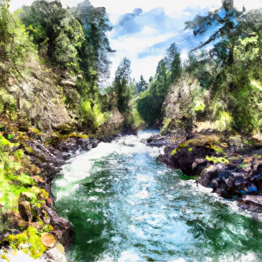
Rogue River
The river has a total segment mileage of 84 miles, with the most popular section being the 34-mile stretch from Grave Creek to Foster Bar. This section is home to several notable rapids, including Rainie Falls, Mule Creek Canyon, and Blossom Bar.
Rainie Falls is a Class V rapid that requires expert navigation skills, while Mule Creek Canyon is a narrow section of the river with several Class III and IV rapids. Blossom Bar is a notorious Class IV rapid with a narrow, technical entrance that requires precise maneuvering.
There are specific regulations for rafting on the Rogue River, including mandatory permits for overnight trips and a limit of 79,000 cubic feet per day for commercial rafting companies. Additionally, visitors are required to follow Leave No Trace principles and properly dispose of all waste.
Overall, the Rogue River offers a thrilling whitewater experience for experienced paddlers, with challenging rapids and stunning scenery. It is important for visitors to follow regulations and respect the natural environment to ensure the sustainability of this beautiful river.
Plan your run down to the hour
Same weather feed Snoflo's iOS app uses -- updated continuously from NOAA / yr.no. Watch the precipitation column on the meteogram; rain ahead of a run typically lifts flows 12-48 hours later depending on the basin.
Next 5 days, hour by hour
Temperature line with weather symbols on top, snow + rain accumulation as columns, humidity as a dotted line.
5-day forecast table
Every 3 hours, broken out across temperature, snow, rain, humidity, and wind. Each cell is colour-coded relative to the column min/max.
| Time | Condition | Temp (°F) | Snow (in) | Rain (in) | Humidity (%) | Wind (mps) | Wind dir |
|---|---|---|---|---|---|---|---|
| Loading detailed forecast… | |||||||
15-day temperature & precipitation
Daily temperatures, snow, and rain projected over the next two weeks -- the upstream story that drives next week's flows.
Regional streamflow levels
USGS streamgauges around Rogue River -- useful for spotting upstream pulses and gauging which tributary is contributing what.
| Streamgauge | Discharge | View |
|---|---|---|
| Rogue R At Cole M Rivers F Hatchery Nr Mcleod | 1,070 cfs | → |
| Big Butte Creek Near Mcleod | 25 cfs | → |
| Rogue River Near Mcleod | 1,430 cfs | → |
| Elk Creek Near Trail | 0 cfs | → |
| Rogue River Below Prospect | 588 cfs | → |
| Rogue River Above Prospect | 811 cfs | → |
Plan a longer trip
The closest boat launches, other paddle runs, and campgrounds so a day on the water can grow into a full weekend.
Boat launches
Other river runs
- Lost Creek Lake To Gold Ray Dam
- Sw1/4 Of Sec 1, T33s, R4e To Rogue River Nf Boundary
- Big Butte Creek (Incl South Fork Big Butte Creek)
- Sams Creek
- Headwaters To Sw1/4 Of Sec 1, T33s, R4e
Campgrounds
- Fire Glen Campground
- Joseph Stewart State Park
- Rogue Elk County Park
- Bear Mountain Rv
- Shady Trails Rv Park
- Rogue River Rv Park
Whitewater safety
- Check the flow before you run
- Use the linked-gauge card and Regional Flow panel above. Class ratings change with flow -- a Class III at low water can become Class IV+ at high water.
- Know your skill ceiling
- Pick runs comfortably below your ceiling. Cold-water and big-water runs raise the consequences of any mistake.
- Wear the right gear
- Helmet, PFD, drysuit / wetsuit when water is below 60°F. Throw bag, knife, and whistle on your person, not in the boat.
- Scout, set safety, and run with a team
- Scout new rapids on foot, set safety with throw bags above the consequence pool, and run with at least one other competent paddler.
- Respect the river
- Strainers, undercuts, low-head dams, and wood can kill at any class rating. When in doubt, portage.
Set push alerts in the Snoflo app
Save Rogue River as a favorite, set a discharge threshold (e.g. "alert me when flow hits 600 cfs"), and the iOS app pushes the moment the linked gauge crosses.
About Rogue River
What's the optimal flow for Rogue River?
The optimal flow depends on the section and the craft. Check the Run Details panel for the linked gauge and current status.
How fresh is the cfs reading on this page?
The linked USGS streamgauge reports continuously (every 15 minutes); Snoflo refreshes throughout the day. Hover the streamflow sparkline to read individual datapoints.
What's the whitewater class?
See the Run Details panel for the class rating Snoflo tracks for this run. Class ratings change with flow -- a Class III at low water can become Class IV in high water.
Where do I put in / take out?
Tap Directions in the hero above to open driving directions to the put-in. For shuttle planning, check the Nearby Boat Launches panel and the river run operator's site.
Can I get alerts when flows hit the optimal range?
Yes -- alerts are managed in the Snoflo iOS app. Favorite this run, set a discharge threshold, and you'll get a push the moment the gauge crosses.
Other runs near here
Snoflo-tracked paddle runs within driving distance of Rogue River.