Molalla River Seg B River Run
Community Reviews
Been here? Share the conditions.
Reviews, ratings & photos are added in the free Snoflo iOS app — rate a spot, tag the conditions, and your visit is verified by location. Add or manage your reviews from the app.
Molalla River Seg B
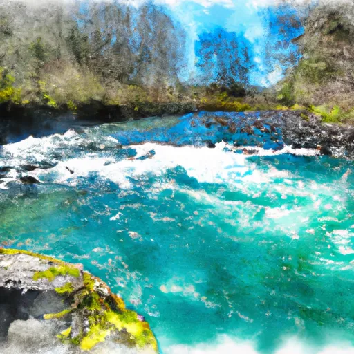
The Molalla River Seg B covers a distance of approximately 5.5 miles and features several notable rapids and obstacles. These include the Funnel, a narrow chute that requires precise maneuvering; the Wall, a long and steep rapid with powerful hydraulics; and the S-Turn, which challenges paddlers with a tight and twisting channel.
To ensure the safety of all visitors, the Oregon State Parks system has established specific regulations for the Molalla River Seg B. Visitors are required to wear personal flotation devices (PFDs) at all times while on the water, and groups must have a designated trip leader with the necessary experience and skills to navigate the segment safely. Additionally, visitors are not allowed to disturb or damage the surrounding natural environment, including plants and wildlife.
Plan your run down to the hour
Same weather feed Snoflo's iOS app uses -- updated continuously from NOAA / yr.no. Watch the precipitation column on the meteogram; rain ahead of a run typically lifts flows 12-48 hours later depending on the basin.
Next 5 days, hour by hour
Temperature line with weather symbols on top, snow + rain accumulation as columns, humidity as a dotted line.
5-day forecast table
Every 3 hours, broken out across temperature, snow, rain, humidity, and wind. Each cell is colour-coded relative to the column min/max.
| Time | Condition | Temp (°F) | Snow (in) | Rain (in) | Humidity (%) | Wind (mps) | Wind dir |
|---|---|---|---|---|---|---|---|
| Loading detailed forecast… | |||||||
15-day temperature & precipitation
Daily temperatures, snow, and rain projected over the next two weeks -- the upstream story that drives next week's flows.
Regional streamflow levels
USGS streamgauges around Molalla River Seg B -- useful for spotting upstream pulses and gauging which tributary is contributing what.
| Streamgauge | Discharge | View |
|---|---|---|
| Bull Creek Near Wilhoit | 0 cfs | → |
| Nate Creek Tributary Near Colton | 0 cfs | → |
| Butte Creek At Monitor | 3 cfs | → |
| Abiqua Creek At Silverton | 74 cfs | → |
| Silver Creek At Silverton | 52 cfs | → |
| Molalla River Near Canby | 63 cfs | → |
Plan a longer trip
The closest boat launches, other paddle runs, and campgrounds so a day on the water can grow into a full weekend.
Boat launches
Other river runs
- North Section Line Of Sec 17, T4s, R5e To Slackwater North Fork Reservoir
- Battle Axe Creek To Willamette Nf Boundary
- Little North Santiam River
- Headwaters To North Section Line Of Sec 17, T4s, R5e
- Clackamas River
Campgrounds
- Three Bears Recreation Site
- Cedar Grove Recreation Site
- Aquila Vista Recreation Site
- Feyrer Park
- Butte Creek Campground
- Metzler Park
Whitewater safety
- Check the flow before you run
- Use the linked-gauge card and Regional Flow panel above. Class ratings change with flow -- a Class III at low water can become Class IV+ at high water.
- Know your skill ceiling
- Pick runs comfortably below your ceiling. Cold-water and big-water runs raise the consequences of any mistake.
- Wear the right gear
- Helmet, PFD, drysuit / wetsuit when water is below 60°F. Throw bag, knife, and whistle on your person, not in the boat.
- Scout, set safety, and run with a team
- Scout new rapids on foot, set safety with throw bags above the consequence pool, and run with at least one other competent paddler.
- Respect the river
- Strainers, undercuts, low-head dams, and wood can kill at any class rating. When in doubt, portage.
Set push alerts in the Snoflo app
Save Molalla River Seg B as a favorite, set a discharge threshold (e.g. "alert me when flow hits 600 cfs"), and the iOS app pushes the moment the linked gauge crosses.
About Molalla River Seg B
What's the optimal flow for Molalla River Seg B?
The optimal flow depends on the section and the craft. Check the Run Details panel for the linked gauge and current status.
How fresh is the cfs reading on this page?
The linked USGS streamgauge reports continuously (every 15 minutes); Snoflo refreshes throughout the day. Hover the streamflow sparkline to read individual datapoints.
What's the whitewater class?
See the Run Details panel for the class rating Snoflo tracks for this run. Class ratings change with flow -- a Class III at low water can become Class IV in high water.
Where do I put in / take out?
Tap Directions in the hero above to open driving directions to the put-in. For shuttle planning, check the Nearby Boat Launches panel and the river run operator's site.
Can I get alerts when flows hit the optimal range?
Yes -- alerts are managed in the Snoflo iOS app. Favorite this run, set a discharge threshold, and you'll get a push the moment the gauge crosses.
Other runs near here
Snoflo-tracked paddle runs within driving distance of Molalla River Seg B.