Eastern Boundary Of Glen Canyon National Recreation Area To Confluence With Lake Powell River Run
Community Reviews
Been here? Share the conditions.
Reviews, ratings & photos are added in the free Snoflo iOS app — rate a spot, tag the conditions, and your visit is verified by location. Add or manage your reviews from the app.
Eastern Boundary Of Glen Canyon National Recreation Area To Confluence With Lake Powell
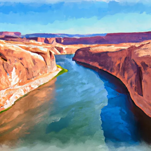
The segment mileage for the Whitewater River Run is approximately 14 miles, starting at the Eastern Boundary of Glen Canyon and ending at the Confluence with Lake Powell. The run is known for its stunning scenery and unique rock formations, including the famous Horseshoe Bend.
Specific regulations to the area include the requirement for a permit to access the river, as well as the need to follow Leave No Trace principles and to pack out all trash. Additionally, there are restrictions on camping and fires, with designated campsites available for overnight stays.
Overall, the Whitewater River Run offers a thrilling and picturesque rafting experience for those looking to explore the natural beauty of Utah's Glen Canyon National Recreation Area.
Plan your run down to the hour
Same weather feed Snoflo's iOS app uses -- updated continuously from NOAA / yr.no. Watch the precipitation column on the meteogram; rain ahead of a run typically lifts flows 12-48 hours later depending on the basin.
Next 5 days, hour by hour
Temperature line with weather symbols on top, snow + rain accumulation as columns, humidity as a dotted line.
5-day forecast table
Every 3 hours, broken out across temperature, snow, rain, humidity, and wind. Each cell is colour-coded relative to the column min/max.
| Time | Condition | Temp (°F) | Snow (in) | Rain (in) | Humidity (%) | Wind (mps) | Wind dir |
|---|---|---|---|---|---|---|---|
| Loading detailed forecast… | |||||||
15-day temperature & precipitation
Daily temperatures, snow, and rain projected over the next two weeks -- the upstream story that drives next week's flows.
Regional streamflow levels
USGS streamgauges around Eastern Boundary Of Glen Canyon National Recreation Area To Confluence With Lake Powell -- useful for spotting upstream pulses and gauging which tributary is contributing what.
| Streamgauge | Discharge | View |
|---|---|---|
| Dirty Devil R Abv Poison Sp Wash Nr Hanksville | 94 cfs | → |
| Recapture Creek Near Blanding | · | → |
| Green River At Mineral Bottom Nr Cynlnds Ntl Park | 2,380 cfs | → |
| South Creek Above Reservoir Near Monticello | 0 cfs | → |
| San Juan River Near Bluff | 763 cfs | → |
| Colorado River At Potash | 1,680 cfs | → |
Plan a longer trip
The closest boat launches, other paddle runs, and campgrounds so a day on the water can grow into a full weekend.
Other river runs
- Boundary Of Glen Canyon National Recreation Area. To Confluence With Colorado River
- Dark Canyon
- Boundary Of Glen Canyon National Recreation Area To Confluence With Lake Powell
- Maidenwater Creek
Whitewater safety
- Check the flow before you run
- Use the linked-gauge card and Regional Flow panel above. Class ratings change with flow -- a Class III at low water can become Class IV+ at high water.
- Know your skill ceiling
- Pick runs comfortably below your ceiling. Cold-water and big-water runs raise the consequences of any mistake.
- Wear the right gear
- Helmet, PFD, drysuit / wetsuit when water is below 60°F. Throw bag, knife, and whistle on your person, not in the boat.
- Scout, set safety, and run with a team
- Scout new rapids on foot, set safety with throw bags above the consequence pool, and run with at least one other competent paddler.
- Respect the river
- Strainers, undercuts, low-head dams, and wood can kill at any class rating. When in doubt, portage.
Set push alerts in the Snoflo app
Save Eastern Boundary Of Glen Canyon National Recreation Area To Confluence With Lake Powell as a favorite, set a discharge threshold (e.g. "alert me when flow hits 600 cfs"), and the iOS app pushes the moment the linked gauge crosses.
About Eastern Boundary Of Glen Canyon National Recreation Area To Confluence With Lake Powell
What's the optimal flow for Eastern Boundary Of Glen Canyon National Recreation Area To Confluence With Lake Powell?
The optimal flow depends on the section and the craft. Check the Run Details panel for the linked gauge and current status.
How fresh is the cfs reading on this page?
The linked USGS streamgauge reports continuously (every 15 minutes); Snoflo refreshes throughout the day. Hover the streamflow sparkline to read individual datapoints.
What's the whitewater class?
See the Run Details panel for the class rating Snoflo tracks for this run. Class ratings change with flow -- a Class III at low water can become Class IV in high water.
Where do I put in / take out?
Tap Directions in the hero above to open driving directions to the put-in. For shuttle planning, check the Nearby Boat Launches panel and the river run operator's site.
Can I get alerts when flows hit the optimal range?
Yes -- alerts are managed in the Snoflo iOS app. Favorite this run, set a discharge threshold, and you'll get a push the moment the gauge crosses.
Other runs near here
Snoflo-tracked paddle runs within driving distance of Eastern Boundary Of Glen Canyon National Recreation Area To Confluence With Lake Powell.