Colorado River River Run
Community Reviews
Been here? Share the conditions.
Reviews, ratings & photos are added in the free Snoflo iOS app — rate a spot, tag the conditions, and your visit is verified by location. Add or manage your reviews from the app.
Colorado River
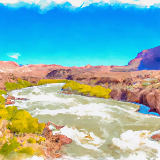
The segment mileage for this run is approximately 10 miles, with several notable rapids and obstacles along the way. One of the most famous rapids on the Whitewater River Run is called Skull Rapid, which is a class IV rapid that requires precise navigation. Other notable rapids include Sock-It-To-Me, Little D, and Last Chance.
There are specific regulations to the area that paddlers should be aware of before embarking on this run. For example, all boaters are required to wear personal flotation devices (PFDs) at all times while on the river. Additionally, campfires are only allowed in designated fire rings, and all trash must be packed out at the end of the trip.
In summary, the Whitewater River Run on the Colorado River in Utah is a challenging and exciting destination for experienced white-water paddlers. With a class rating of III-IV, ideal streamflow range of 8,000 to 22,000 cfs, and several notable rapids and obstacles, this section of the river offers a thrilling adventure for those who are up to the challenge. However, it’s important to be aware of the specific regulations and guidelines for the area to ensure a safe and enjoyable trip.
Plan your run down to the hour
Same weather feed Snoflo's iOS app uses -- updated continuously from NOAA / yr.no. Watch the precipitation column on the meteogram; rain ahead of a run typically lifts flows 12-48 hours later depending on the basin.
Next 5 days, hour by hour
Temperature line with weather symbols on top, snow + rain accumulation as columns, humidity as a dotted line.
5-day forecast table
Every 3 hours, broken out across temperature, snow, rain, humidity, and wind. Each cell is colour-coded relative to the column min/max.
| Time | Condition | Temp (°F) | Snow (in) | Rain (in) | Humidity (%) | Wind (mps) | Wind dir |
|---|---|---|---|---|---|---|---|
| Loading detailed forecast… | |||||||
15-day temperature & precipitation
Daily temperatures, snow, and rain projected over the next two weeks -- the upstream story that drives next week's flows.
Regional streamflow levels
USGS streamgauges around Colorado River -- useful for spotting upstream pulses and gauging which tributary is contributing what.
| Streamgauge | Discharge | View |
|---|---|---|
| Colorado River At Potash | 1,720 cfs | → |
| Mill Creek Blw Pack Creek Nr Mouth At Moab | 1 cfs | → |
| Mill Creek Below Sheley Tunnel | 3 cfs | → |
| Castle Creek Below Castle Valley Near Moab | 4 cfs | → |
| Mill Creek At Sheley Tunnel | 3 cfs | → |
| Green River At Mineral Bottom Nr Cynlnds Ntl Park | 1,860 cfs | → |
Plan a longer trip
The closest boat launches, other paddle runs, and campgrounds so a day on the water can grow into a full weekend.
Boat launches
Campgrounds
Fishing spots
Parks
- Swanny City Park
- Dead Horse Point State Park
- Sand Flats Recreation Area
- Arches National Park
- Old City Park
Points of interest
Whitewater safety
- Check the flow before you run
- Use the linked-gauge card and Regional Flow panel above. Class ratings change with flow -- a Class III at low water can become Class IV+ at high water.
- Know your skill ceiling
- Pick runs comfortably below your ceiling. Cold-water and big-water runs raise the consequences of any mistake.
- Wear the right gear
- Helmet, PFD, drysuit / wetsuit when water is below 60°F. Throw bag, knife, and whistle on your person, not in the boat.
- Scout, set safety, and run with a team
- Scout new rapids on foot, set safety with throw bags above the consequence pool, and run with at least one other competent paddler.
- Respect the river
- Strainers, undercuts, low-head dams, and wood can kill at any class rating. When in doubt, portage.
Set push alerts in the Snoflo app
Save Colorado River as a favorite, set a discharge threshold (e.g. "alert me when flow hits 600 cfs"), and the iOS app pushes the moment the linked gauge crosses.
About Colorado River
What's the optimal flow for Colorado River?
The optimal flow depends on the section and the craft. Check the Run Details panel for the linked gauge and current status.
How fresh is the cfs reading on this page?
The linked USGS streamgauge reports continuously (every 15 minutes); Snoflo refreshes throughout the day. Hover the streamflow sparkline to read individual datapoints.
What's the whitewater class?
See the Run Details panel for the class rating Snoflo tracks for this run. Class ratings change with flow -- a Class III at low water can become Class IV in high water.
Where do I put in / take out?
Tap Directions in the hero above to open driving directions to the put-in. For shuttle planning, check the Nearby Boat Launches panel and the river run operator's site.
Can I get alerts when flows hit the optimal range?
Yes -- alerts are managed in the Snoflo iOS app. Favorite this run, set a discharge threshold, and you'll get a push the moment the gauge crosses.
Other runs near here
Snoflo-tracked paddle runs within driving distance of Colorado River.