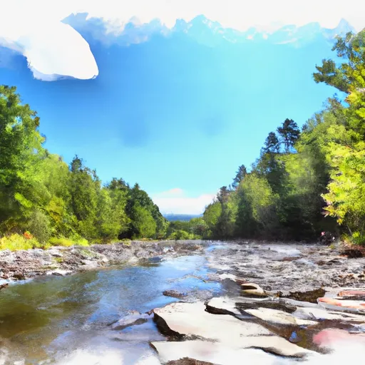
Wilderness Boundary To Confluence With Batten Kill river run
Community Reviews
Been here? Share the conditions.
Reviews, ratings & photos are added in the free Snoflo iOS app — rate a spot, tag the conditions, and your visit is verified by location. Add or manage your reviews from the app.
Wilderness Boundary To Confluence With Batten Kill
Throughout this segment, paddlers will encounter several notable rapids, including S-Turn, Pinball, and Roller Coaster. S-Turn is a series of ledges and drops that requires precise maneuvering, while Pinball features several large boulders that create challenging hydraulics. Roller Coaster is a fast and technical rapid that requires quick reactions and good boat control.
To ensure the safety of all visitors, the Vermont Department of Forests, Parks, and Recreation has specific regulations in place for this area. All paddlers are required to wear a properly fitting personal flotation device (PFD) at all times while on the river. Additionally, paddlers should be aware of potential hazards such as strainers (obstacles that can trap boats and paddlers) and should avoid portaging (carrying boats around obstacles) on private property without permission.
Overall, the Wilderness Boundary to Confluence with Batten Kill segment of the Whitewater River offers a thrilling whitewater experience for intermediate to advanced paddlers, with challenging rapids and stunning scenery. Paddlers should always check current streamflow conditions and adhere to all regulations to ensure a safe and enjoyable trip.
Plan your run down to the hour
Same weather feed Snoflo's iOS app uses -- updated continuously from NOAA / yr.no. Watch the precipitation column on the meteogram; rain ahead of a run typically lifts flows 12-48 hours later depending on the basin.
Next 5 days, hour by hour
Temperature line with weather symbols on top, snow + rain accumulation as columns, humidity as a dotted line.
5-day forecast table
Every 3 hours, broken out across temperature, snow, rain, humidity, and wind. Each cell is colour-coded relative to the column min/max.
| Time | Condition | Temp (°F) | Snow (in) | Rain (in) | Humidity (%) | Wind (mps) | Wind dir |
|---|---|---|---|---|---|---|---|
| Loading detailed forecast… | |||||||
15-day temperature & precipitation
Daily temperatures, snow, and rain projected over the next two weeks -- the upstream story that drives next week's flows.
Regional streamflow levels
USGS streamgauges around Wilderness Boundary To Confluence With Batten Kill -- useful for spotting upstream pulses and gauging which tributary is contributing what.
| Streamgauge | Discharge | View |
|---|---|---|
| West River At Jamaica | 41 cfs | → |
| Mettawee River Near Pawlet | 215 cfs | → |
| West River Below Townshend Dam Near Townshend | 46 cfs | → |
| Batten Kill Below Mill At Battenville Ny | 237 cfs | → |
| Walloomsac River Near North Bennington | 49 cfs | → |
| Hoosic River Near Eagle Bridge Ny | 295 cfs | → |
Plan a longer trip
The closest boat launches, other paddle runs, and campgrounds so a day on the water can grow into a full weekend.
Boat launches
- Dufresne Pond Road Manchester
- Town Shed Road Manchester
- Gale Meadow Road Londonderry
- Batten Kill Road Arlington
- Winhall Station Road Londonderry
- Somerset
Other river runs
- Lye Brook Wilderness Boundary To Confluence Of Batten Kill
- Arlington, Vt To Manchester, Vt
- Headwaters To End Of Kendall Farm Road
- End Of Kendall Farm Road To Confluence With West River
- Headwaters To Wilderness Boundary
Campgrounds
- North Bourne Pond
- South Bourne Pond
- Stratton View Tenting Area
- Camping On The Battenkill
- Emerald Lake State Park
- Grout Pond Recreation Area
Whitewater safety
- Check the flow before you run
- Use the linked-gauge card and Regional Flow panel above. Class ratings change with flow -- a Class III at low water can become Class IV+ at high water.
- Know your skill ceiling
- Pick runs comfortably below your ceiling. Cold-water and big-water runs raise the consequences of any mistake.
- Wear the right gear
- Helmet, PFD, drysuit / wetsuit when water is below 60°F. Throw bag, knife, and whistle on your person, not in the boat.
- Scout, set safety, and run with a team
- Scout new rapids on foot, set safety with throw bags above the consequence pool, and run with at least one other competent paddler.
- Respect the river
- Strainers, undercuts, low-head dams, and wood can kill at any class rating. When in doubt, portage.
Set push alerts in the Snoflo app
Save Wilderness Boundary To Confluence With Batten Kill as a favorite, set a discharge threshold (e.g. "alert me when flow hits 600 cfs"), and the iOS app pushes the moment the linked gauge crosses.
About Wilderness Boundary To Confluence With Batten Kill
What's the optimal flow for Wilderness Boundary To Confluence With Batten Kill?
The optimal flow depends on the section and the craft. Check the Run Details panel for the linked gauge and current status.
How fresh is the cfs reading on this page?
The linked USGS streamgauge reports continuously (every 15 minutes); Snoflo refreshes throughout the day. Hover the streamflow sparkline to read individual datapoints.
What's the whitewater class?
See the Run Details panel for the class rating Snoflo tracks for this run. Class ratings change with flow -- a Class III at low water can become Class IV in high water.
Where do I put in / take out?
Tap Directions in the hero above to open driving directions to the put-in. For shuttle planning, check the Nearby Boat Launches panel and the river run operator's site.
Can I get alerts when flows hit the optimal range?
Yes -- alerts are managed in the Snoflo iOS app. Favorite this run, set a discharge threshold, and you'll get a push the moment the gauge crosses.
Other runs near here
Snoflo-tracked paddle runs within driving distance of Wilderness Boundary To Confluence With Batten Kill.