Whites Run To National Recreation Area Boundary Near Us 33 River Run
Community Reviews
Been here? Share the conditions.
Reviews, ratings & photos are added in the free Snoflo iOS app — rate a spot, tag the conditions, and your visit is verified by location. Add or manage your reviews from the app.
Whites Run To National Recreation Area Boundary Near Us 33
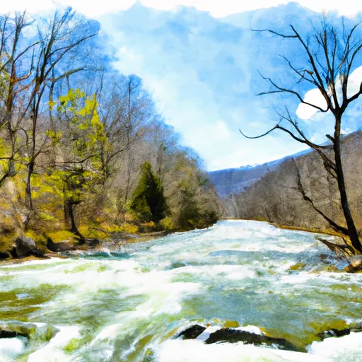
This section of the river is classified as Class III, which means that it features moderate rapids with complex maneuvers required. The segment is approximately 7.7 miles long and features several notable rapids, including Horseshoe Falls, Split Decision, and Fuzzy Box of Kittens. Paddlers should be prepared to navigate a variety of obstacles, including rocks, waves, and eddies.
There are several regulations that apply to the Whitewater River Run. All paddlers are required to wear a personal flotation device (PFD) at all times while on the river. Additionally, all boats must be equipped with a whistle and a white light visible for at least one mile. Alcohol is prohibited on the river, and paddlers should also be aware of any fire restrictions that may be in place.
Overall, the Whitewater River Run offers an exciting and challenging paddling experience for experienced whitewater enthusiasts. However, paddlers should always exercise caution and be prepared for changing river conditions.
Plan your run down to the hour
Same weather feed Snoflo's iOS app uses -- updated continuously from NOAA / yr.no. Watch the precipitation column on the meteogram; rain ahead of a run typically lifts flows 12-48 hours later depending on the basin.
Next 5 days, hour by hour
Temperature line with weather symbols on top, snow + rain accumulation as columns, humidity as a dotted line.
5-day forecast table
Every 3 hours, broken out across temperature, snow, rain, humidity, and wind. Each cell is colour-coded relative to the column min/max.
| Time | Condition | Temp (°F) | Snow (in) | Rain (in) | Humidity (%) | Wind (mps) | Wind dir |
|---|---|---|---|---|---|---|---|
| Loading detailed forecast… | |||||||
15-day temperature & precipitation
Daily temperatures, snow, and rain projected over the next two weeks -- the upstream story that drives next week's flows.
Regional streamflow levels
USGS streamgauges around Whites Run To National Recreation Area Boundary Near Us 33 -- useful for spotting upstream pulses and gauging which tributary is contributing what.
| Streamgauge | Discharge | View |
|---|---|---|
| N F South Br Potomac R At Cabins | 70 cfs | → |
| South Branch Potomac River At Franklin | 42 cfs | → |
| Shavers Fork Below Bowden | 175 cfs | → |
| Dry Fork At Hendricks | 347 cfs | → |
| So. Branch Potomac River Nr Petersburg | 172 cfs | → |
| Blackwater R At Davis | 107 cfs | → |
Plan a longer trip
The closest boat launches, other paddle runs, and campgrounds so a day on the water can grow into a full weekend.
Other river runs
- Private Land Above Falls Of Seneca To Whites Run
- Run North Of Judy Springs To Private Land
- .5 North Of Us 33 To Shears Hollow
- Enter Dolly Sods Wilderness To Exit Dolly Sods Wilderness
- Canyon Exit To Spruce Knob-Seneca Rocks Nra Boundary
Campgrounds
- Seneca Rocks Rv Resort
- Seneca Shadows Campground
- Princess Snowbird Campground
- Cooper's Campground
- Scenic Campground
- Judy Springs
Fishing spots
Whitewater safety
- Check the flow before you run
- Use the linked-gauge card and Regional Flow panel above. Class ratings change with flow -- a Class III at low water can become Class IV+ at high water.
- Know your skill ceiling
- Pick runs comfortably below your ceiling. Cold-water and big-water runs raise the consequences of any mistake.
- Wear the right gear
- Helmet, PFD, drysuit / wetsuit when water is below 60°F. Throw bag, knife, and whistle on your person, not in the boat.
- Scout, set safety, and run with a team
- Scout new rapids on foot, set safety with throw bags above the consequence pool, and run with at least one other competent paddler.
- Respect the river
- Strainers, undercuts, low-head dams, and wood can kill at any class rating. When in doubt, portage.
Set push alerts in the Snoflo app
Save Whites Run To National Recreation Area Boundary Near Us 33 as a favorite, set a discharge threshold (e.g. "alert me when flow hits 600 cfs"), and the iOS app pushes the moment the linked gauge crosses.
About Whites Run To National Recreation Area Boundary Near Us 33
What's the optimal flow for Whites Run To National Recreation Area Boundary Near Us 33?
The optimal flow depends on the section and the craft. Check the Run Details panel for the linked gauge and current status.
How fresh is the cfs reading on this page?
The linked USGS streamgauge reports continuously (every 15 minutes); Snoflo refreshes throughout the day. Hover the streamflow sparkline to read individual datapoints.
What's the whitewater class?
See the Run Details panel for the class rating Snoflo tracks for this run. Class ratings change with flow -- a Class III at low water can become Class IV in high water.
Where do I put in / take out?
Tap Directions in the hero above to open driving directions to the put-in. For shuttle planning, check the Nearby Boat Launches panel and the river run operator's site.
Can I get alerts when flows hit the optimal range?
Yes -- alerts are managed in the Snoflo iOS app. Favorite this run, set a discharge threshold, and you'll get a push the moment the gauge crosses.
Other runs near here
Snoflo-tracked paddle runs within driving distance of Whites Run To National Recreation Area Boundary Near Us 33.