Run North Of Judy Springs To Private Land River Run
Community Reviews
Been here? Share the conditions.
Reviews, ratings & photos are added in the free Snoflo iOS app — rate a spot, tag the conditions, and your visit is verified by location. Add or manage your reviews from the app.
Run North Of Judy Springs To Private Land
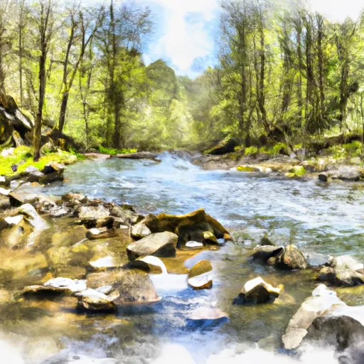
One of the most significant rapids on this stretch of the river is called "S-turn," which is a long rapid with multiple drops and tight turns. Other notable rapids include "Rollercoaster," "Sidways," and "The Fast Lane." These rapids offer plenty of opportunities for thrilling whitewater experiences.
There are several regulations to keep in mind when visiting this section of the river. It is important to note that this portion of the Whitewater River is on private land. Therefore, it is essential to obtain permission before accessing the river from private property. Additionally, all boaters are required to wear personal flotation devices, and firearms are not permitted.
Overall, the Whitewater River Run North of Judy Springs to Private Land is an exciting adventure for experienced whitewater paddlers. It offers challenging rapids, beautiful scenery, and a chance to test your skills on one of West Virginia's most exhilarating rivers.
Plan your run down to the hour
Same weather feed Snoflo's iOS app uses -- updated continuously from NOAA / yr.no. Watch the precipitation column on the meteogram; rain ahead of a run typically lifts flows 12-48 hours later depending on the basin.
Next 5 days, hour by hour
Temperature line with weather symbols on top, snow + rain accumulation as columns, humidity as a dotted line.
5-day forecast table
Every 3 hours, broken out across temperature, snow, rain, humidity, and wind. Each cell is colour-coded relative to the column min/max.
| Time | Condition | Temp (°F) | Snow (in) | Rain (in) | Humidity (%) | Wind (mps) | Wind dir |
|---|---|---|---|---|---|---|---|
| Loading detailed forecast… | |||||||
15-day temperature & precipitation
Daily temperatures, snow, and rain projected over the next two weeks -- the upstream story that drives next week's flows.
Regional streamflow levels
USGS streamgauges around Run North Of Judy Springs To Private Land -- useful for spotting upstream pulses and gauging which tributary is contributing what.
| Streamgauge | Discharge | View |
|---|---|---|
| South Branch Potomac River At Franklin | 34 cfs | → |
| So Fk So Br Potomac R At Brandywine | 11 cfs | → |
| Shavers Fork Below Bowden | 136 cfs | → |
| Tygart Valley River Near Dailey | 78 cfs | → |
| Shavers Fork Nr Cheat Bridge | 37 cfs | → |
| N F South Br Potomac R At Cabins | 51 cfs | → |
Plan a longer trip
The closest boat launches, other paddle runs, and campgrounds so a day on the water can grow into a full weekend.
Other river runs
- Trussel Run To Run North Of Judy Springs
- Private Land Above Falls Of Seneca To Whites Run
- Forest Land At Entrance Of Laurel Fork South Wilderness To Exit Laurel Fork North Wilderness
- Whites Run To National Recreation Area Boundary Near Us 33
- Forks To Frazier Creek
Campgrounds
- Scenic Campground
- Judy Springs
- Gatewood Campground
- Spruce Knob Lake Campground
- Back Ridge Shadows Campground
- Seneca Shadows Campground
Fishing spots
- Dry Fork
- Briery Branch Day Use Area
- Elkhorn Lake Day Use Area
- Staunton Dam Day Use Area
- Braley Pond Day Use Area
- Tomahawk Pond Day Use Area
Whitewater safety
- Check the flow before you run
- Use the linked-gauge card and Regional Flow panel above. Class ratings change with flow -- a Class III at low water can become Class IV+ at high water.
- Know your skill ceiling
- Pick runs comfortably below your ceiling. Cold-water and big-water runs raise the consequences of any mistake.
- Wear the right gear
- Helmet, PFD, drysuit / wetsuit when water is below 60°F. Throw bag, knife, and whistle on your person, not in the boat.
- Scout, set safety, and run with a team
- Scout new rapids on foot, set safety with throw bags above the consequence pool, and run with at least one other competent paddler.
- Respect the river
- Strainers, undercuts, low-head dams, and wood can kill at any class rating. When in doubt, portage.
Set push alerts in the Snoflo app
Save Run North Of Judy Springs To Private Land as a favorite, set a discharge threshold (e.g. "alert me when flow hits 600 cfs"), and the iOS app pushes the moment the linked gauge crosses.
About Run North Of Judy Springs To Private Land
What's the optimal flow for Run North Of Judy Springs To Private Land?
The optimal flow depends on the section and the craft. Check the Run Details panel for the linked gauge and current status.
How fresh is the cfs reading on this page?
The linked USGS streamgauge reports continuously (every 15 minutes); Snoflo refreshes throughout the day. Hover the streamflow sparkline to read individual datapoints.
What's the whitewater class?
See the Run Details panel for the class rating Snoflo tracks for this run. Class ratings change with flow -- a Class III at low water can become Class IV in high water.
Where do I put in / take out?
Tap Directions in the hero above to open driving directions to the put-in. For shuttle planning, check the Nearby Boat Launches panel and the river run operator's site.
Can I get alerts when flows hit the optimal range?
Yes -- alerts are managed in the Snoflo iOS app. Favorite this run, set a discharge threshold, and you'll get a push the moment the gauge crosses.
Other runs near here
Snoflo-tracked paddle runs within driving distance of Run North Of Judy Springs To Private Land.