Bridge At Tongue River Canyon To Burgess Picnic Grounds River Run
Community Reviews
Been here? Share the conditions.
Reviews, ratings & photos are added in the free Snoflo iOS app — rate a spot, tag the conditions, and your visit is verified by location. Add or manage your reviews from the app.
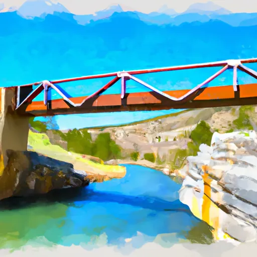
Bridge At Tongue River Canyon To Burgess Picnic Grounds
One of the most significant rapids on this segment is called "Cable Rapid," which is a class III+ rapid that requires good paddling skills and precise maneuvering. Other notable rapids include "Little Bullwhacker" and "Elkhorn," both of which are class III rapids. There are also a few smaller rapids and obstacles that provide a thrilling ride down the river.
In terms of regulations, anyone using this segment of the Tongue River should be aware that it is located within the Bighorn National Forest and is subject to specific rules and regulations. For example, visitors are required to obtain a permit before using the river, and certain areas may be off-limits at certain times of the year. Additionally, visitors should be aware of potential hazards, such as fallen trees or debris in the water.
Overall, the Bridge at Tongue River Canyon to Burgess Picnic Grounds segment is a thrilling and challenging whitewater river run that offers a unique experience for whitewater enthusiasts in Wyoming. With the ideal streamflow range, class III rating, and a few notable rapids and obstacles, this segment is a must-visit for anyone looking to test their skills on the water.
Plan your run down to the hour
Same weather feed Snoflo's iOS app uses -- updated continuously from NOAA / yr.no. Watch the precipitation column on the meteogram; rain ahead of a run typically lifts flows 12-48 hours later depending on the basin.
Next 5 days, hour by hour
Temperature line with weather symbols on top, snow + rain accumulation as columns, humidity as a dotted line.
5-day forecast table
Every 3 hours, broken out across temperature, snow, rain, humidity, and wind. Each cell is colour-coded relative to the column min/max.
| Time | Condition | Temp (°F) | Snow (in) | Rain (in) | Humidity (%) | Wind (mps) | Wind dir |
|---|---|---|---|---|---|---|---|
| Loading detailed forecast… | |||||||
15-day temperature & precipitation
Daily temperatures, snow, and rain projected over the next two weeks -- the upstream story that drives next week's flows.
Regional streamflow levels
USGS streamgauges around Bridge At Tongue River Canyon To Burgess Picnic Grounds -- useful for spotting upstream pulses and gauging which tributary is contributing what.
| Streamgauge | Discharge | View |
|---|---|---|
| Tongue River Near Dayton | 48 cfs | → |
| East Pass Creek Near Dayton | 12 cfs | → |
| West Pass Creek Near Parkman | 10 cfs | → |
| Tongue River At Monarch | 383 cfs | → |
| Goose Creek Near Acme | 123 cfs | → |
| Little Bighorn River At State Line Nr Wyola Mt | 86 cfs | → |
Plan a longer trip
The closest boat launches, other paddle runs, and campgrounds so a day on the water can grow into a full weekend.
Other river runs
- Sf Tongue- Johnson Creek To Confluence With Nf Tongue
- Nf Tongue From Burgess Picnic Ground To Pole Creek
- Dry Fork River From Its Confluence With Lake Creek To Confluence With Little Big Horn
- Wagon Box Creek To Dry Fork Trail
- Fools Gold Crossing (Fdr 480) To Wagon Box Creek
Campgrounds
- Tongue Canyon Campground
- Tongue River Camp - Amsden Creek Wma
- Sibley Lake Campground
- Sibley Lake
- Arrowhead Lodge
- Prune Creek
Whitewater safety
- Check the flow before you run
- Use the linked-gauge card and Regional Flow panel above. Class ratings change with flow -- a Class III at low water can become Class IV+ at high water.
- Know your skill ceiling
- Pick runs comfortably below your ceiling. Cold-water and big-water runs raise the consequences of any mistake.
- Wear the right gear
- Helmet, PFD, drysuit / wetsuit when water is below 60°F. Throw bag, knife, and whistle on your person, not in the boat.
- Scout, set safety, and run with a team
- Scout new rapids on foot, set safety with throw bags above the consequence pool, and run with at least one other competent paddler.
- Respect the river
- Strainers, undercuts, low-head dams, and wood can kill at any class rating. When in doubt, portage.
Set push alerts in the Snoflo app
Save Bridge At Tongue River Canyon To Burgess Picnic Grounds as a favorite, set a discharge threshold (e.g. "alert me when flow hits 600 cfs"), and the iOS app pushes the moment the linked gauge crosses.
About Bridge At Tongue River Canyon To Burgess Picnic Grounds
What's the optimal flow for Bridge At Tongue River Canyon To Burgess Picnic Grounds?
The optimal flow depends on the section and the craft. Check the Run Details panel for the linked gauge and current status.
How fresh is the cfs reading on this page?
The linked USGS streamgauge reports continuously (every 15 minutes); Snoflo refreshes throughout the day. Hover the streamflow sparkline to read individual datapoints.
What's the whitewater class?
See the Run Details panel for the class rating Snoflo tracks for this run. Class ratings change with flow -- a Class III at low water can become Class IV in high water.
Where do I put in / take out?
Tap Directions in the hero above to open driving directions to the put-in. For shuttle planning, check the Nearby Boat Launches panel and the river run operator's site.
Can I get alerts when flows hit the optimal range?
Yes -- alerts are managed in the Snoflo iOS app. Favorite this run, set a discharge threshold, and you'll get a push the moment the gauge crosses.
Other runs near here
Snoflo-tracked paddle runs within driving distance of Bridge At Tongue River Canyon To Burgess Picnic Grounds.