Cliff Creek Confluence To Snake River Confluence River Run
Community Reviews
Been here? Share the conditions.
Reviews, ratings & photos are added in the free Snoflo iOS app — rate a spot, tag the conditions, and your visit is verified by location. Add or manage your reviews from the app.
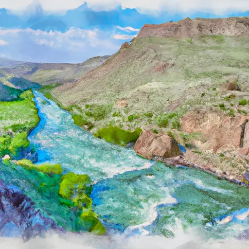
Cliff Creek Confluence To Snake River Confluence
There are several notable rapids and obstacles on this segment, including the Class IV Big Kahuna rapid and the Class III Lunch Counter rapid. Other rapids such as the Million Dollar Fishing Hole, White Wave, and Ropes End provide additional excitement and challenges for paddlers. It is important to note that these rapids can be dangerous at high water levels and should only be attempted by experienced paddlers.
There are several regulations and guidelines that must be followed when paddling this segment. All paddlers must wear a personal flotation device (PFD) at all times, and it is recommended to wear a helmet as well. Additionally, there are restrictions on the number of boats allowed on the river at any given time, and permits are required for commercial outfitters.
Overall, the Whitewater River Run from Cliff Creek Confluence to Snake River Confluence is a thrilling and challenging whitewater adventure for experienced paddlers. It is important to check current streamflow levels and adhere to all regulations and guidelines to ensure a safe and enjoyable experience on the water.
Plan your run down to the hour
Same weather feed Snoflo's iOS app uses -- updated continuously from NOAA / yr.no. Watch the precipitation column on the meteogram; rain ahead of a run typically lifts flows 12-48 hours later depending on the basin.
Next 5 days, hour by hour
Temperature line with weather symbols on top, snow + rain accumulation as columns, humidity as a dotted line.
5-day forecast table
Every 3 hours, broken out across temperature, snow, rain, humidity, and wind. Each cell is colour-coded relative to the column min/max.
| Time | Condition | Temp (°F) | Snow (in) | Rain (in) | Humidity (%) | Wind (mps) | Wind dir |
|---|---|---|---|---|---|---|---|
| Loading detailed forecast… | |||||||
15-day temperature & precipitation
Daily temperatures, snow, and rain projected over the next two weeks -- the upstream story that drives next week's flows.
Regional streamflow levels
USGS streamgauges around Cliff Creek Confluence To Snake River Confluence -- useful for spotting upstream pulses and gauging which tributary is contributing what.
| Streamgauge | Discharge | View |
|---|---|---|
| Snake River Bl Flat Creek Nr Jackson Wy | 7,190 cfs | → |
| Cache Creek Near Jackson | 14 cfs | → |
| Snake River Ab Reservoir Nr Alpine Wy | 6,940 cfs | → |
| Flat Creek Bel Cache Creek | 209 cfs | → |
| Green River At Warren Bridge | 769 cfs | → |
| Gros Ventre River At Zenith Wy | 149 cfs | → |
Plan a longer trip
The closest boat launches, other paddle runs, and campgrounds so a day on the water can grow into a full weekend.
Boat launches
- King's Wave Kayak Access
- Snake River
- East Table Boating Site
- West Table Boating Site
- Taco Hole Kayak Access
Other river runs
- Hoback Canyon
- Granite Creek
- Source To Cliff Creek Trailhead
- Source, Pickle Pass To Confluence With Hoback River
- South Park Bridge To 1 Mile Downstream From Astoria Hot Springs (North Section Line Of Sec 5, T38n, R116w)
Campgrounds
- Black Powder Cabins And Camping
- Kozy
- Kozy Campground
- Hoback Guard Station
- Hoback Campground
- Hoback Camping
Fishing spots
Whitewater safety
- Check the flow before you run
- Use the linked-gauge card and Regional Flow panel above. Class ratings change with flow -- a Class III at low water can become Class IV+ at high water.
- Know your skill ceiling
- Pick runs comfortably below your ceiling. Cold-water and big-water runs raise the consequences of any mistake.
- Wear the right gear
- Helmet, PFD, drysuit / wetsuit when water is below 60°F. Throw bag, knife, and whistle on your person, not in the boat.
- Scout, set safety, and run with a team
- Scout new rapids on foot, set safety with throw bags above the consequence pool, and run with at least one other competent paddler.
- Respect the river
- Strainers, undercuts, low-head dams, and wood can kill at any class rating. When in doubt, portage.
Set push alerts in the Snoflo app
Save Cliff Creek Confluence To Snake River Confluence as a favorite, set a discharge threshold (e.g. "alert me when flow hits 600 cfs"), and the iOS app pushes the moment the linked gauge crosses.
About Cliff Creek Confluence To Snake River Confluence
What's the optimal flow for Cliff Creek Confluence To Snake River Confluence?
The optimal flow depends on the section and the craft. Check the Run Details panel for the linked gauge and current status.
How fresh is the cfs reading on this page?
The linked USGS streamgauge reports continuously (every 15 minutes); Snoflo refreshes throughout the day. Hover the streamflow sparkline to read individual datapoints.
What's the whitewater class?
See the Run Details panel for the class rating Snoflo tracks for this run. Class ratings change with flow -- a Class III at low water can become Class IV in high water.
Where do I put in / take out?
Tap Directions in the hero above to open driving directions to the put-in. For shuttle planning, check the Nearby Boat Launches panel and the river run operator's site.
Can I get alerts when flows hit the optimal range?
Yes -- alerts are managed in the Snoflo iOS app. Favorite this run, set a discharge threshold, and you'll get a push the moment the gauge crosses.
Other runs near here
Snoflo-tracked paddle runs within driving distance of Cliff Creek Confluence To Snake River Confluence.