Green River River Run
Community Reviews
Been here? Share the conditions.
Reviews, ratings & photos are added in the free Snoflo iOS app — rate a spot, tag the conditions, and your visit is verified by location. Add or manage your reviews from the app.
Green River
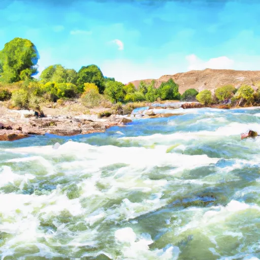
The Green River is rated as a Class II-III river, which means it has moderate rapids with some rough water. The river has a total segment mileage of 80 miles and is broken up into three sections: the A, B, and C sections. The A section is 7 miles long and is the most challenging part of the river, rated as Class III-IV. The B section is 13 miles long and is rated as Class II-III, making it a great option for intermediate paddlers. The C section is 60 miles long and is rated as Class I-II, making it a great option for families and beginners.
There are several specific rapids and obstacles on the Green River that paddlers should be aware of. In the A section, the biggest rapids are the Big Drop 2 and the Little Niagara, which are both Class IV rapids. In the B section, there are several notable rapids, including the Red Creek Rapid and the Horseshoe Canyon Rapid. In the C section, there are no major rapids, but there are several smaller rapids and fun wave trains.
There are several regulations and rules that paddlers must follow when on the Green River. All paddlers must have a personal flotation device (PFD) on at all times, and helmets are strongly recommended. There are also restrictions on camping along the river, so paddlers should plan their trip accordingly. Additionally, there are regulations on fishing and hunting along the river, so paddlers should be aware of these rules before planning their trip.
Overall, the Green River in Wyoming offers a fantastic whitewater experience for paddlers of all skill levels. With its beautiful scenery, exciting rapids, and clear water, it is a great destination for anyone looking for a fun and challenging river run.
Plan your run down to the hour
Same weather feed Snoflo's iOS app uses -- updated continuously from NOAA / yr.no. Watch the precipitation column on the meteogram; rain ahead of a run typically lifts flows 12-48 hours later depending on the basin.
Next 5 days, hour by hour
Temperature line with weather symbols on top, snow + rain accumulation as columns, humidity as a dotted line.
5-day forecast table
Every 3 hours, broken out across temperature, snow, rain, humidity, and wind. Each cell is colour-coded relative to the column min/max.
| Time | Condition | Temp (°F) | Snow (in) | Rain (in) | Humidity (%) | Wind (mps) | Wind dir |
|---|---|---|---|---|---|---|---|
| Loading detailed forecast… | |||||||
15-day temperature & precipitation
Daily temperatures, snow, and rain projected over the next two weeks -- the upstream story that drives next week's flows.
Regional streamflow levels
USGS streamgauges around Green River -- useful for spotting upstream pulses and gauging which tributary is contributing what.
| Streamgauge | Discharge | View |
|---|---|---|
| Green River At Warren Bridge | 954 cfs | → |
| Pine Creek Above Fremont Lake | 322 cfs | → |
| New Fork River Near Big Piney | 718 cfs | → |
| Snake River Bl Flat Creek Nr Jackson Wy | 7,280 cfs | → |
| Dinwoody Creek Above Lakes | 484 cfs | → |
| Wind River Near Dubois | 146 cfs | → |
Plan a longer trip
The closest boat launches, other paddle runs, and campgrounds so a day on the water can grow into a full weekend.
Boat launches
- Green River Access Site 3 Boat Launch
- Green River Access Site 5 Boat Ramp
- Green River Access Site 2 Boat Launch
- Green River Access Site 6 Boat Launch
- Green River Access Site 1 Boat Ramp
- Green River Access Site 8 Boat Launch
Campgrounds
- Green River Access Site 3 Campsite 3
- Upper Green River Access
- Green River Access Site 3 Campsite 2
- Green River Access Site 3 Campsite 1
- Green River Access Site 4 Campsite 1
- Green River Access Site 2 Campsite 3
Fishing spots
Whitewater safety
- Check the flow before you run
- Use the linked-gauge card and Regional Flow panel above. Class ratings change with flow -- a Class III at low water can become Class IV+ at high water.
- Know your skill ceiling
- Pick runs comfortably below your ceiling. Cold-water and big-water runs raise the consequences of any mistake.
- Wear the right gear
- Helmet, PFD, drysuit / wetsuit when water is below 60°F. Throw bag, knife, and whistle on your person, not in the boat.
- Scout, set safety, and run with a team
- Scout new rapids on foot, set safety with throw bags above the consequence pool, and run with at least one other competent paddler.
- Respect the river
- Strainers, undercuts, low-head dams, and wood can kill at any class rating. When in doubt, portage.
Set push alerts in the Snoflo app
Save Green River as a favorite, set a discharge threshold (e.g. "alert me when flow hits 600 cfs"), and the iOS app pushes the moment the linked gauge crosses.
About Green River
What's the optimal flow for Green River?
The optimal flow depends on the section and the craft. Check the Run Details panel for the linked gauge and current status.
How fresh is the cfs reading on this page?
The linked USGS streamgauge reports continuously (every 15 minutes); Snoflo refreshes throughout the day. Hover the streamflow sparkline to read individual datapoints.
What's the whitewater class?
See the Run Details panel for the class rating Snoflo tracks for this run. Class ratings change with flow -- a Class III at low water can become Class IV in high water.
Where do I put in / take out?
Tap Directions in the hero above to open driving directions to the put-in. For shuttle planning, check the Nearby Boat Launches panel and the river run operator's site.
Can I get alerts when flows hit the optimal range?
Yes -- alerts are managed in the Snoflo iOS app. Favorite this run, set a discharge threshold, and you'll get a push the moment the gauge crosses.
Other runs near here
Snoflo-tracked paddle runs within driving distance of Green River.