Green River River Run
Community Reviews
Been here? Share the conditions.
Reviews, ratings & photos are added in the free Snoflo iOS app — rate a spot, tag the conditions, and your visit is verified by location. Add or manage your reviews from the app.
Green River
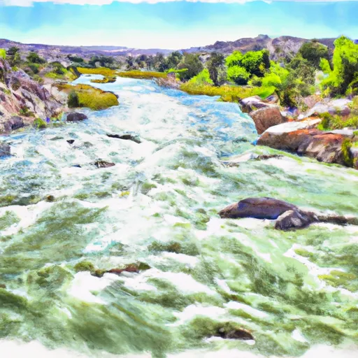
There are several notable rapids and obstacles on the Green River, including Red Creek Rapids, Horseshoe Canyon, and Hell's Half Mile. The river also features scenic canyon views and opportunities for wildlife viewing.
In terms of regulations, paddlers are required to obtain a permit from the National Park Service to access the river. Additionally, there are restrictions on camping and group size, with a maximum group size of 15 people allowed on the river at any given time. Paddlers are also required to follow Leave No Trace principles and pack out all trash and waste.
Overall, the Green River is a unique and challenging whitewater river run that offers beautiful scenery and exciting rapids for experienced paddlers to enjoy.
Plan your run down to the hour
Same weather feed Snoflo's iOS app uses -- updated continuously from NOAA / yr.no. Watch the precipitation column on the meteogram; rain ahead of a run typically lifts flows 12-48 hours later depending on the basin.
Next 5 days, hour by hour
Temperature line with weather symbols on top, snow + rain accumulation as columns, humidity as a dotted line.
5-day forecast table
Every 3 hours, broken out across temperature, snow, rain, humidity, and wind. Each cell is colour-coded relative to the column min/max.
| Time | Condition | Temp (°F) | Snow (in) | Rain (in) | Humidity (%) | Wind (mps) | Wind dir |
|---|---|---|---|---|---|---|---|
| Loading detailed forecast… | |||||||
15-day temperature & precipitation
Daily temperatures, snow, and rain projected over the next two weeks -- the upstream story that drives next week's flows.
Regional streamflow levels
USGS streamgauges around Green River -- useful for spotting upstream pulses and gauging which tributary is contributing what.
| Streamgauge | Discharge | View |
|---|---|---|
| Green River At Warren Bridge | 822 cfs | → |
| Pine Creek Above Fremont Lake | 275 cfs | → |
| Wind River Near Dubois | 233 cfs | → |
| Dinwoody Creek Above Lakes | 547 cfs | → |
| Wind River Above Red Creek | 1,320 cfs | → |
| New Fork River Near Big Piney | 727 cfs | → |
Plan a longer trip
The closest boat launches, other paddle runs, and campgrounds so a day on the water can grow into a full weekend.
Boat launches
- Green River Access Site 12 Boat Ramp
- Green River Access Site 8 Boat Launch
- Green River Access Site 6 Boat Launch
- Green River Access Site 5 Boat Ramp
- New Fork Lake
- Green River Access Site 3 Boat Launch
Campgrounds
- Green River Access Site 11 Campsite 2
- Green River Access Site 11 Campsite 1
- Green River Access Site 12 Campsite 1
- Green River Access Site 10 Campsite 1
- Green River Access Site 9 Campsite 3
- Green River Access Site 9 Campsite 2
Fishing spots
Points of interest
Whitewater safety
- Check the flow before you run
- Use the linked-gauge card and Regional Flow panel above. Class ratings change with flow -- a Class III at low water can become Class IV+ at high water.
- Know your skill ceiling
- Pick runs comfortably below your ceiling. Cold-water and big-water runs raise the consequences of any mistake.
- Wear the right gear
- Helmet, PFD, drysuit / wetsuit when water is below 60°F. Throw bag, knife, and whistle on your person, not in the boat.
- Scout, set safety, and run with a team
- Scout new rapids on foot, set safety with throw bags above the consequence pool, and run with at least one other competent paddler.
- Respect the river
- Strainers, undercuts, low-head dams, and wood can kill at any class rating. When in doubt, portage.
Set push alerts in the Snoflo app
Save Green River as a favorite, set a discharge threshold (e.g. "alert me when flow hits 600 cfs"), and the iOS app pushes the moment the linked gauge crosses.
About Green River
What's the optimal flow for Green River?
The optimal flow depends on the section and the craft. Check the Run Details panel for the linked gauge and current status.
How fresh is the cfs reading on this page?
The linked USGS streamgauge reports continuously (every 15 minutes); Snoflo refreshes throughout the day. Hover the streamflow sparkline to read individual datapoints.
What's the whitewater class?
See the Run Details panel for the class rating Snoflo tracks for this run. Class ratings change with flow -- a Class III at low water can become Class IV in high water.
Where do I put in / take out?
Tap Directions in the hero above to open driving directions to the put-in. For shuttle planning, check the Nearby Boat Launches panel and the river run operator's site.
Can I get alerts when flows hit the optimal range?
Yes -- alerts are managed in the Snoflo iOS app. Favorite this run, set a discharge threshold, and you'll get a push the moment the gauge crosses.
Other runs near here
Snoflo-tracked paddle runs within driving distance of Green River.