South Fork Shoshone River River Run
Community Reviews
Been here? Share the conditions.
Reviews, ratings & photos are added in the free Snoflo iOS app — rate a spot, tag the conditions, and your visit is verified by location. Add or manage your reviews from the app.
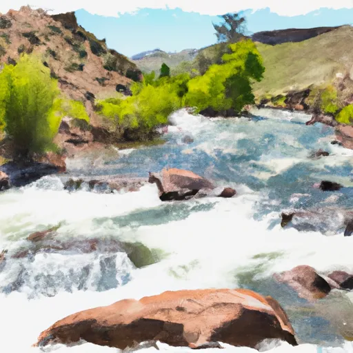
South Fork Shoshone River
The South Fork Shoshone River has several notable rapids and obstacles, including "The Narrows," a narrow section of the river with several drops and boulders. Another highlight is "Dead Indian," a long and continuous rapid that requires careful navigation. There are also several smaller rapids and waves throughout the run that provide a fun and challenging experience.
When it comes to regulations, the South Fork Shoshone River is managed by the Bureau of Land Management. Permits are not required for private boaters, but commercial outfitters must obtain a permit. The river is open to boating from May through September, with peak flow typically occurring in June.
Overall, the South Fork Shoshone River offers an exciting and challenging whitewater experience for intermediate to advanced paddlers. It is important to check current streamflow conditions and to be prepared for the rapids and obstacles before embarking on this river run.
Plan your run down to the hour
Same weather feed Snoflo's iOS app uses -- updated continuously from NOAA / yr.no. Watch the precipitation column on the meteogram; rain ahead of a run typically lifts flows 12-48 hours later depending on the basin.
Next 5 days, hour by hour
Temperature line with weather symbols on top, snow + rain accumulation as columns, humidity as a dotted line.
5-day forecast table
Every 3 hours, broken out across temperature, snow, rain, humidity, and wind. Each cell is colour-coded relative to the column min/max.
| Time | Condition | Temp (°F) | Snow (in) | Rain (in) | Humidity (%) | Wind (mps) | Wind dir |
|---|---|---|---|---|---|---|---|
| Loading detailed forecast… | |||||||
15-day temperature & precipitation
Daily temperatures, snow, and rain projected over the next two weeks -- the upstream story that drives next week's flows.
Regional streamflow levels
USGS streamgauges around South Fork Shoshone River -- useful for spotting upstream pulses and gauging which tributary is contributing what.
| Streamgauge | Discharge | View |
|---|---|---|
| South Fork Shoshone River Ab Buffalo Bill Res | 650 cfs | → |
| North Fork Shoshone River At Wapiti | 1,070 cfs | → |
| Shoshone River Below Buffalo Bill Reservoir | 315 cfs | → |
| South Fork Shoshone River Near Valley | 187 cfs | → |
| Greybull River At Meeteetse | 338 cfs | → |
| Clarks Fork Yellowstone River Nr Belfry Mt | 2,000 cfs | → |
Plan a longer trip
The closest boat launches, other paddle runs, and campgrounds so a day on the water can grow into a full weekend.
Boat launches
- Andy Martin Hill Boat Ramp
- Buffalo Bill Reservoir
- North Fork Shoshone River Boat Ramp
- Newton Lake, East
Campgrounds
- Buffalo Bill State Park
- W.O.W. Cottage 3bed 2bath
- Yellowstone Valley Inn
- Wheels Of Wonderment Motorcycle Campground
- Bobcat-Houlihan Lower Camping Area
- Bobcat-Houlihan Recreation Area
Fishing spots
Parks
Whitewater safety
- Check the flow before you run
- Use the linked-gauge card and Regional Flow panel above. Class ratings change with flow -- a Class III at low water can become Class IV+ at high water.
- Know your skill ceiling
- Pick runs comfortably below your ceiling. Cold-water and big-water runs raise the consequences of any mistake.
- Wear the right gear
- Helmet, PFD, drysuit / wetsuit when water is below 60°F. Throw bag, knife, and whistle on your person, not in the boat.
- Scout, set safety, and run with a team
- Scout new rapids on foot, set safety with throw bags above the consequence pool, and run with at least one other competent paddler.
- Respect the river
- Strainers, undercuts, low-head dams, and wood can kill at any class rating. When in doubt, portage.
Set push alerts in the Snoflo app
Save South Fork Shoshone River as a favorite, set a discharge threshold (e.g. "alert me when flow hits 600 cfs"), and the iOS app pushes the moment the linked gauge crosses.
About South Fork Shoshone River
What's the optimal flow for South Fork Shoshone River?
The optimal flow depends on the section and the craft. Check the Run Details panel for the linked gauge and current status.
How fresh is the cfs reading on this page?
The linked USGS streamgauge reports continuously (every 15 minutes); Snoflo refreshes throughout the day. Hover the streamflow sparkline to read individual datapoints.
What's the whitewater class?
See the Run Details panel for the class rating Snoflo tracks for this run. Class ratings change with flow -- a Class III at low water can become Class IV in high water.
Where do I put in / take out?
Tap Directions in the hero above to open driving directions to the put-in. For shuttle planning, check the Nearby Boat Launches panel and the river run operator's site.
Can I get alerts when flows hit the optimal range?
Yes -- alerts are managed in the Snoflo iOS app. Favorite this run, set a discharge threshold, and you'll get a push the moment the gauge crosses.
Other runs near here
Snoflo-tracked paddle runs within driving distance of South Fork Shoshone River.