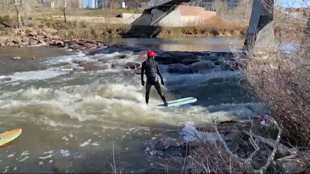
16th Street Wave

Downtown Denver urban wave at the pedestrian bridge just down river from the 15th Street bridge over the S. Platte and is an eyeshot from Confluence Park.


Suggestions

This is a shallow wave that is truthfully hard to surf. For example, beware of a few very shallow rocks, about 15 feet down from the wave on surfers left side that you might encounter coming off your board.... Knowing the risks of rocks in and around this wave, it is worth a go when the flow is pushing 200cfs. Crowds of passerby's walking across the 16th Street pedestrian bridge will be flipping out seeing you surf right below them. For more info on this spot check out Endless Waves http://endlesswaves.net/waves/16th-street-wave/

Disclaimer: Snoflo assumes no responsibility for errors or omissions in any of the content found here. You, the user assumes the entire risk associated with use of this data and content. terms of service
Image Alt

Some of the Denver Surf Punks (Casey, Larry, Michael, and Nathan) were getting the surf at 16th Street Bridge Friday. Casey thrilling the crowd watching from above on this ride.

Area Hydrology

Gauge Streamflow Stage
South Platte River Above Cheesman Lake
USGS 06700000
234 cfs 5.6 ft
So. Platte R. Blw Brush Cr. Nr Trumbull Co
USGS 06701900
277 cfs 3.7 ft
Trout Creek Blw Fern Cr Nr Westcreek
USGS 06701620
1 cfs 3.8 ft
South Platte River Below Cheesman Lake
USGS 06701500
184 cfs 1.3 ft
Cherry Creek Near Franktown
USGS 06712000
8 cfs 3.0 ft
Cache La Poudre R A Mo Of Cn
USGS 06752000
1,960 cfs 5.3 ft
N Frk Cache La Poudre R Blw Halligan Res Nr V Dal
USGS 06751150
346 cfs 4.0 ft
North Fork Cache La Poudre R. At Livermore
USGS 06751490
366 cfs 9.4 ft
Monument C Ab N.Gate Blvd At Usaf Academy
USGS 07103780
21 cfs 1.5 ft
West Cr. Abv Shrewsbury Gulch Nr Westcreek Co
USGS 06701700
1 cfs 5.3 ft
Snotel Site Snowpack 24hr Change
Bear Lake
SNOTEL 322
2" 0"
Sawtooth
SNOTEL 1251
7" -2"
South Colony
SNOTEL 773
1" 0"
Echo Lake
SNOTEL 936
1" 0"
University Camp
SNOTEL 838
13" -1"
Hourglass Lake
SNOTEL 1122
1" 0"

Outdoor Recreation

Campground Campsites Reservations Toilets Showers Elevation
Carter Lake - South Side Campgrounds None 5,711 ft
Boulder County Fairground None 4,974 ft
Bear Creek Lake Park 52 5,693 ft
Thunder Ridge 21 9,216 ft
Standley Lake None 5,530 ft
Meadow Ridge 19 9,177 ft
Indian Creek 11 7,562 ft
Cherry Creek State Park 102 5,646 ft
Inlet Bay - Horsetooth Reservoir None 5,437 ft
Platte River 10 6,333 ft
Farish Military - USAF Academy None 9,083 ft
Boyd Lake State Park 148 4,991 ft
Colorado 81 7,806 ft
South Bay - Horsetooth Reservoir None 5,435 ft
Painted Rocks 18 7,836 ft
Flat Rocks 19 8,245 ft
Union Reservoir 42 4,957 ft
South Meadows 64 7,897 ft
Springdale 13 9,304 ft
Jackson Creek 9 8,179 ft
Devils Head 21 8,856 ft
Missile Site Park 12 4,942 ft
Trail Creek None 7,844 ft
Carter Lake - North Side Campgrounds None 5,792 ft
Osprey 13 6,217 ft
Ouzel 13 6,285 ft
Peregrine Pines Military - USAF Academy None 6,631 ft
Chatfield State Park 193 5,494 ft
St. Vrain State Park 87 4,850 ft
Ski Area Snowpack Air Temperature 5 Day Forecast
Ski Broadmoor 0" 52° 0"
River Run Streamflow Length Class
Idledale to Morrison 202.0cfs 3.0 Mi IV+ to V
Filter Plant 1680.0cfs None Mi II to III+
NSV 1050.0cfs 13.0 Mi V+
Gnar Section 642.0cfs 1.0 Mi V+
SSV - Confluence to Picnic Grounds 1050.0cfs 5.0 Mi V to V+
Main Section 1100.0cfs 3.0 Mi IV+ to V
Royal Gorge 2540.0cfs 10.0 Mi IV- to IV
Middle Narrows 1960.0cfs 1.0 Mi IV to V-
Lower Boulder Canyon 642.0cfs None Mi IV- to V-
Tunnel 1 to Golden Whitewater Park 1010.0cfs None Mi III- to III+
Upper South Boulder Creek 864.0cfs None Mi V+
Golden Whitewater Park 1680.0cfs 0.75 Mi II+
Filter Plant 1680.0cfs None Mi II to III+
Lower North Fork 1960.0cfs 11.0 Mi III
Upper Clear Creek 1010.0cfs 2.5 Mi IV- to IV+
Steven's Gulch to Bridges Take Out 1960.0cfs 12.0 Mi III- to IV+
Upper Narrows 1960.0cfs 0.5 Mi V- to V+
Upper North Fork 346.0cfs 9.0 Mi IV+ to V-
October Hole 1050.0cfs None Mi II
Upper South Boulder Creek 864.0cfs None Mi V+
Lower Narrows 1960.0cfs 0.5 Mi V- to V+