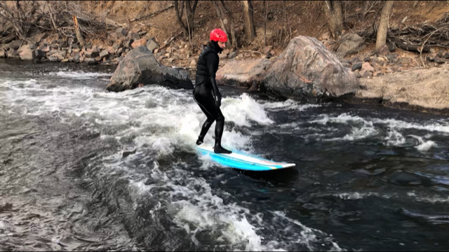
Beaver Wave

Beavers is a fun small wave to hit when RRP is just missing the enough water flows. Most people are surfing Beavers with a longboard or something with a good amount of volume. The wave comes in best at about 120cfs but can be surfed much lower than that. Unfortunately the wave blows out when it gets to 400cfs but you will likely be at RRP surfing if the flow is that high.


Suggestions

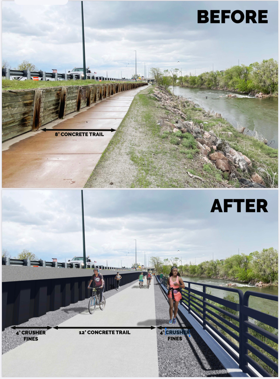
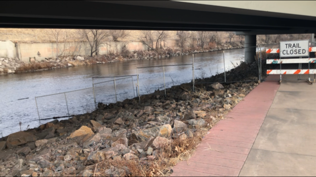
NOTE, the 2021 and likely 2022 surf seasons access to Beaver's is via wading into the river and paddling up from the fence line to the river to the wave just up from the parking lot.... Be cautious using the bike path, it is closed for emergency construction repairs to the failed retaining wall on the bike path (does not impact the river). Also, beware of dangerous rocks behind the wave, and new rock directly under the wave on surfers left. For more info on Beavers Wave check http://endlesswaves.net/waves/beaver-wave/

Disclaimer: Snoflo assumes no responsibility for errors or omissions in any of the content found here. You, the user assumes the entire risk associated with use of this data and content. terms of service
Image Alt

Access to Beaver's is via wading into the river and paddling up from the fence line to the river to the wave.... Do not use the bike path, it is closed for emergency construction repairs to the failed retaining wall on the bike path (does not impact the river).... So be cool and do not use the bike path at all, to protect our river entry point and rights to surf the wave!!!

Image Alt

Fun low flow session at 75cfs and 39 degrees water temp. (surfer- Casey Cupp styling it on his 7 foot longboard)

Image Alt

The failing retaining wall at Beavers will be replaced, along with upgrades made to the trail in this area. We need to work as a surf community to get proper steps built down to Beavers as part of the $8million being spent to shore up the road, fix the retaining wall, and widen the path. Project Timeline: Winter 2022: Design complete Spring-Fall 2023: Construction

Area Hydrology

Gauge Streamflow Stage
Big Dry Creek At Mouth Near Fort Lupton
USGS 06720990
71 cfs 1.9 ft
N Frk Cache La Poudre R Blw Halligan Res Nr V Dal
USGS 06751150
33 cfs 2.4 ft
Boulder Cr At North 75Th St Nr Boulder
USGS 06730200
24 cfs 4.5 ft
South St. Vrain Creek Near Ward
USGS 06722500
5 cfs 1.5 ft
St. Vrain Creek At Lyons
USGS 06724000
56 cfs 3.1 ft
Boulder Creek Near Orodell
USGS 06727000
16 cfs 1.8 ft
Fourmile Creek At Orodell
USGS 06727500
1 cfs 4.4 ft
Snotel Site Snowpack 24hr Change

Outdoor Recreation

Campground Campsites Reservations Toilets Showers Elevation
Flat Rocks 19 8,245 ft
Farish Military - USAF Academy None 9,083 ft
Boulder County Fairground None 4,974 ft
South Bay - Horsetooth Reservoir None 5,435 ft
Chatfield State Park 193 5,494 ft
Mueller State Park 90 9,313 ft
Painted Rocks 18 7,836 ft
Colorado 81 7,806 ft
Thunder Ridge 21 9,216 ft
Union Reservoir 42 4,957 ft
The Crags 17 10,120 ft
Devils Head 21 8,856 ft
Platte River 10 6,333 ft
Jackson Creek 9 8,179 ft
Cherry Creek State Park 102 5,646 ft
Osprey 13 6,217 ft
Ouzel 13 6,285 ft
Springdale 13 9,304 ft
Boyd Lake State Park 148 4,991 ft
Inlet Bay - Horsetooth Reservoir None 5,437 ft
Indian Creek 11 7,562 ft
Bear Creek Lake Park 52 5,693 ft
Carter Lake - South Side Campgrounds None 5,711 ft
South Meadows 64 7,897 ft
St. Vrain State Park 87 4,850 ft
Peregrine Pines Military - USAF Academy None 6,631 ft
Standley Lake None 5,530 ft
Trail Creek None 7,844 ft
Missile Site Park 12 4,942 ft
Meadow Ridge 19 9,177 ft
Ski Area Snowpack Air Temperature 5 Day Forecast
River Run Streamflow Length Class