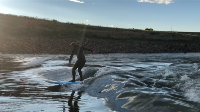
Miracle Wave

Miracle wave is mellow knee to waist high glass wave that is a miracle when it comes in on the average of every three years but oh so zen-like to surf it. The wave is located 100 yards down from the the outflow of the Chatfield Reservoir into the S. Platte River at the Chatfield State Park adjacent to the dog park.


Suggestions

Miracle needs a flow of at least a thousand cfs (1,000cfs). The wave is shallow and the water, well it usually is baked with dash of E.coli and added in parasites like giardiasis and cryptosporidiosis for good measure, so don't drink the water. Bring a longboard to surf Miracle wave and be prepared to fall flat as possible due to the rocks right behind and all along the wave. Last time the wave came in it was 2019 and 2016 before that. Unfortunately with the completion of the expansion of the Chatfield Reservoir in 2020 that increased the ability to hold more water, it will take an epic water event (aka crazy amount of rain) or an incredible snow season for the water managers to open up the gates to dump another 1,000cfs or more of water, but never say never.... The first stream gauge to watch for Miracle and many of the other S. Platte surfable waves is the South Platte River Below Chatfield Reservoir (PLACHACO) but the Union gauge is also a good indicator but it is hours down river from Miracle and you will be missing the wave when it comes in and the flow lasts a day or two if not only a few hours... Find more detailed info at http://endlesswaves.net/waves/miracle-wave/ but stick to checking the surf reports at Snoflo for the inside info of when Miracle is surfable.

Disclaimer: Snoflo assumes no responsibility for errors or omissions in any of the content found here. You, the user assumes the entire risk associated with use of this data and content. terms of service
Image Alt

Ethan getting the start of the wave showing up at Miracle in June 2019 and he had it dialed in for sure.... Notice how wide and glassy this urban river wave is in metro Denver.

Area Hydrology

Gauge Streamflow Stage
South Platte River Near Kersey
USGS 06754000
585 cfs 3.0 ft
West Monument Creek At Air Force Academy
USGS 07103800
3 cfs 1.3 ft
Big Dry Creek At Westminster
USGS 06720820
1 cfs 1.5 ft
West Cr. Abv Shrewsbury Gulch Nr Westcreek Co
USGS 06701700
1 cfs 5.3 ft
Cache La Poudre River Near Greeley
USGS 06752500
104 cfs 1.9 ft
South Platte River At South Platte
USGS 06707500
302 cfs 2.6 ft
Fountain Cr Bl Janitell Rd Bl Colo. Springs
USGS 07105530
41 cfs 5.8 ft
Cherry Creek Near Franktown
USGS 06712000
2 cfs 2.6 ft
St. Vrain Creek Below Longmont
USGS 06725450
-999,999 cfs ft
Monument Cr At Bijou St.
USGS 07104905
26 cfs 3.7 ft
Snotel Site Snowpack 24hr Change
Ute Creek
SNOTEL 1005
38" 2"
Lake Eldora
SNOTEL 564
40" 0"
Black Mountain
SNOTEL 1161
44" 0"
South Colony
SNOTEL 773
72" 1"
Glen Cove
SNOTEL 1057
5" 0"
Copeland Lake
SNOTEL 412
19" -1"
University Camp
SNOTEL 838
53" 1"
Hourglass Lake
SNOTEL 1122
44" 0"
Bear Lake
SNOTEL 322
69" -1"
Sawtooth
SNOTEL 1251
72" 0"

Outdoor Recreation

Campground Campsites Reservations Toilets Showers Elevation
Ouzel 13 6,285 ft
Devils Head 21 8,856 ft
Trail Creek None 7,844 ft
Painted Rocks 18 7,836 ft
Standley Lake None 5,530 ft
Osprey 13 6,217 ft
Flat Rocks 19 8,245 ft
South Meadows 64 7,897 ft
Jackson Creek 9 8,179 ft
Platte River 10 6,333 ft
Farish Military - USAF Academy None 9,083 ft
Bear Creek Lake Park 52 5,693 ft
Indian Creek 11 7,562 ft
Colorado 81 7,806 ft
Chatfield State Park 193 5,494 ft
Ski Area Snowpack Air Temperature 5 Day Forecast
River Run Streamflow Length Class
Upper Clear Creek 60.7cfs 2.5 Mi IV- to IV+
Golden Whitewater Park 3.92cfs 0.75 Mi II+
October Hole 37.8cfs None Mi II
Tunnel 1 to Golden Whitewater Park 60.7cfs None Mi III- to III+
Main Section 55.3cfs 3.0 Mi IV+ to V
Lower Boulder Canyon 42.0cfs None Mi IV- to V-
SSV - Confluence to Picnic Grounds 37.8cfs 5.0 Mi V to V+
Gnar Section 405.0cfs 1.0 Mi V+
Idledale to Morrison 11.2cfs 3.0 Mi IV+ to V