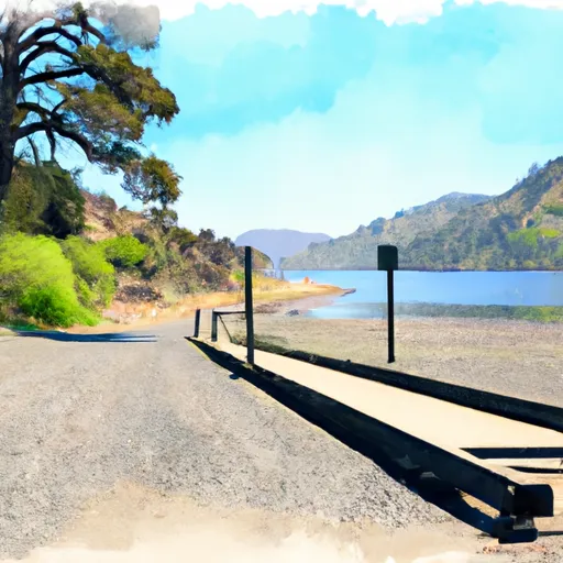
Granite Peak Road, Trinity Center boat launch
Community Reviews
Been here? Share the conditions.
Reviews, ratings & photos are added in the free Snoflo iOS app — rate a spot, tag the conditions, and your visit is verified by location. Add or manage your reviews from the app.
Granite Peak Road, Trinity Center
Trinity Lake is popular for a variety of water-based recreational activities, including boating, fishing, water skiing, and swimming. The lake covers over 17,000 acres and has a maximum depth of 240 feet. The lake is home to various species of fish, including rainbow and brown trout, largemouth and smallmouth bass, and catfish.
As for the craft permitted on the water, all types of boats are allowed on Trinity Lake, including powerboats, kayaks, canoes, and paddleboards. However, boaters must adhere to all safety regulations and have the proper permits and equipment on board.
Overall, the Granite Peak Road boat ramp is a convenient and accessible launch point for boaters looking to enjoy Trinity Lake's scenic beauty and recreational opportunities.
Plan your launch down to the hour
Same weather feed Snoflo's iOS app uses -- updated continuously from NOAA / yr.no.
Next 5 days, hour by hour
Temperature line with weather symbols on top, snow + rain accumulation as columns, humidity as a dotted line.
5-day forecast table
Every 3 hours, broken out across temperature, snow, rain, humidity, and wind.
| Time | Condition | Temp (°F) | Snow (in) | Rain (in) | Humidity (%) | Wind (mps) | Wind dir |
|---|---|---|---|---|---|---|---|
| Loading detailed forecast… | |||||||
15-day temperature & precipitation
Daily temperatures, snow, and rain projected over the next two weeks.
Area streamflow levels
USGS streamgauges around Granite Peak Road, Trinity Center -- the same readings that determine whether your launch is safe and your boat is the right craft.
| Streamgauge | Discharge | View |
|---|---|---|
| Rush C Nr Lewiston Ca | 2 cfs | → |
| Trinity R A Lewiston Ca | 450 cfs | → |
| Grass Valley C Nr Lewiston Ca | 18 cfs | → |
| Trinity R Bl Limekiln Gulch Nr Douglas City Ca | 471 cfs | → |
| Indian C Nr Douglas City Ca | 6 cfs | → |
| Trinity R A Junction City Ca | 499 cfs | → |
Plan a longer trip
The closest paddle runs, fishing spots, and other boat launches so you can extend a day on the water.
River runs
- Canyon Creek Trailhead To Confluence With Mainstream Trinity River
- Headwaters At Outlet Of Lower Canyon Creek Lake To Canyon Creek Trailhead At Ripstein Canyon Creek Trailhead At Ripstein
- Confluence Of Tributaries In Sec 6 Near Black Mtn. To Confluence With Blind Horse Creek
- North Fork Cottonwood Creek
- Clear Creek
- Headwaters In Sw 1/4, Sec 24, T8n, R12w To Trinity Wsr (At Hobo Gulch Trailhead And Campground)
Nearby fishing
Boating safety & etiquette
- Check the conditions before you launch
- Use the streamflow numbers, weather, and wind forecast on this page. High-cfs whitewater requires whitewater-specific craft and skill.
- Wear your life jacket
- Statistically the single biggest survival factor in a boating incident. State law often requires one per passenger.
- File a float plan
- Tell someone on shore your put-in, take-out, and expected return time. Especially for multi-day or remote trips.
- Yield at the ramp
- Prep gear in the parking lot, not on the ramp. Launch and clear quickly so others can use the lane.
- Clean, drain, dry
- Inspect, clean, drain and dry your boat between waters to prevent the spread of aquatic invasive species.
Set push alerts in the Snoflo app
Save Granite Peak Road, Trinity Center as a favorite, set a discharge threshold or a wind/precipitation alert, and the iOS app will push the moment conditions cross.
About Granite Peak Road, Trinity Center
Can I launch a motorboat here?
Most Snoflo-tracked launches support motorboats; check the operator for any horsepower restrictions, paddle-only zones, or seasonal closures.
How fresh is the streamflow data?
USGS streamgauges report continuously (every 15 minutes); the table on this page pulls the latest reading at page load.
Is there a fee?
Many federal and state boat launches charge a day-use fee. Check the operator's site before driving out.
What boat is right for these conditions?
Use the nearby streamflow numbers and river-run panel on this page to gauge current conditions. Wider, slower water is friendly for casual paddling and powerboats; high-cfs whitewater requires whitewater-specific craft and skill.
Can I get alerts when conditions change?
Yes -- alerts are managed in the Snoflo iOS app. Favorite this launch, set a threshold (discharge, wind), and you'll get a push the moment it crosses.
Other launches near here
Snoflo-tracked boat launches within driving distance of Granite Peak Road, Trinity Center.