William Tugman State Park Boat Launch
Community Reviews
Been here? Share the conditions.
Reviews, ratings & photos are added in the free Snoflo iOS app — rate a spot, tag the conditions, and your visit is verified by location. Add or manage your reviews from the app.
William Tugman State Park
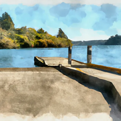
The William Tugman State Park boat ramp is approximately 16 feet wide, which is wide enough to accommodate most types of watercraft. The ramp is also equipped with a suitable slope, which makes it easy to launch and retrieve boats of various sizes.
Eel Lake is a popular destination for boating enthusiasts in the area. The lake is approximately 2.5 miles long and 1.5 miles wide, with a maximum depth of 76 feet. It is a great spot for fishing, kayaking and canoeing, as well as water skiing and wakeboarding. Motorized watercraft are allowed on the lake, including powerboats, jet skis, and sailboats.
In terms of the latest information available, the Oregon State Parks website provides up-to-date details on the William Tugman State Park boat ramp and its facilities. Visitors are encouraged to check the website before heading out to ensure that there are no closures or other issues affecting their planned activities.
Plan your launch down to the hour
Same weather feed Snoflo's iOS app uses -- updated continuously from NOAA / yr.no.
Next 5 days, hour by hour
Temperature line with weather symbols on top, snow + rain accumulation as columns, humidity as a dotted line.
5-day forecast table
Every 3 hours, broken out across temperature, snow, rain, humidity, and wind.
| Time | Condition | Temp (°F) | Snow (in) | Rain (in) | Humidity (%) | Wind (mps) | Wind dir |
|---|---|---|---|---|---|---|---|
| Loading detailed forecast… | |||||||
15-day temperature & precipitation
Daily temperatures, snow, and rain projected over the next two weeks.
Plan a longer trip
The closest paddle runs, fishing spots, and other boat launches so you can extend a day on the water.
River runs
- Eastern Siuslaw Nf Boundary To East Section Line Of Ne1/4se1/4 Of Sec 16, T21s, R10w
- East Section Line Of Ne1/4se1/4 Of Sec 16, T21s, R10w To Confluence With Smith River
- East Section Line Of Sec 36, T19s, R10w To South Section Line Of Sec 32, T19s, R10w
- Confluence With Jump Creek To East Section Line Of Sec 36, T19s, R10w
- South Fork Coos River
- Eastern Siuslaw Nf Boundary To Confluence With Jump Creek
Boating safety & etiquette
- Check the conditions before you launch
- Use the streamflow numbers, weather, and wind forecast on this page. High-cfs whitewater requires whitewater-specific craft and skill.
- Wear your life jacket
- Statistically the single biggest survival factor in a boating incident. State law often requires one per passenger.
- File a float plan
- Tell someone on shore your put-in, take-out, and expected return time. Especially for multi-day or remote trips.
- Yield at the ramp
- Prep gear in the parking lot, not on the ramp. Launch and clear quickly so others can use the lane.
- Clean, drain, dry
- Inspect, clean, drain and dry your boat between waters to prevent the spread of aquatic invasive species.
Set push alerts in the Snoflo app
Save William Tugman State Park as a favorite, set a discharge threshold or a wind/precipitation alert, and the iOS app will push the moment conditions cross.
About William Tugman State Park
Can I launch a motorboat here?
Most Snoflo-tracked launches support motorboats; check the operator for any horsepower restrictions, paddle-only zones, or seasonal closures.
How fresh is the streamflow data?
USGS streamgauges report continuously (every 15 minutes); the table on this page pulls the latest reading at page load.
Is there a fee?
Many federal and state boat launches charge a day-use fee. Check the operator's site before driving out.
What boat is right for these conditions?
Use the nearby streamflow numbers and river-run panel on this page to gauge current conditions. Wider, slower water is friendly for casual paddling and powerboats; high-cfs whitewater requires whitewater-specific craft and skill.
Can I get alerts when conditions change?
Yes -- alerts are managed in the Snoflo iOS app. Favorite this launch, set a threshold (discharge, wind), and you'll get a push the moment it crosses.
Other launches near here
Snoflo-tracked boat launches within driving distance of William Tugman State Park.