Emma Wood State Beach Campground
Community Reviews
Been here? Share the conditions.
Reviews, ratings & photos are added in the free Snoflo iOS app — rate a spot, tag the conditions, and your visit is verified by location. Add or manage your reviews from the app.
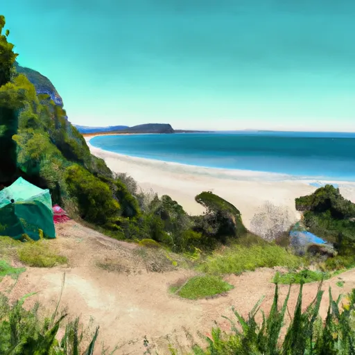
Emma Wood State Beach
What's on-site at Emma Wood State Beach
Key facilities Snoflo tracks for this campground. Confirm with the operator before booking -- amenities can change seasonally.
Plan your trip down to the hour
Same weather feed Snoflo's iOS app uses -- updated continuously from NOAA / yr.no.
Next 5 days, hour by hour
Temperature line with weather symbols on top, snow + rain accumulation as columns, humidity as a dotted line.
5-day forecast table
Every 3 hours, broken out across temperature, snow, rain, humidity, and wind. Each cell is colour-coded relative to the column min/max so trends jump out at a glance.
| Time | Condition | Temp (°F) | Snow (in) | Rain (in) | Humidity (%) | Wind (mps) | Wind dir |
|---|---|---|---|---|---|---|---|
| Loading detailed forecast… | |||||||
15-day temperature & precipitation
Daily temperatures, snow, and rain projected over the next two weeks. Hover any point for the full breakdown.
Other campgrounds in the area
Snoflo-tracked campsites within driving distance of Emma Wood State Beach, with reservations status.
| Campground | Reservations | Toilets | View |
|---|---|---|---|
| Hike/Bike Campsite | ✗ | ✗ | → |
| State Beach Rv On The Water | ✗ | ✗ | → |
| Foster Park | ✗ | ✗ | → |
| Mcgrath State Beach | ✓ | ✓ | → |
| Lake Side Group Camp | ✗ | ✗ | → |
Nearby streamflow
USGS streamgauges within reach of Emma Wood State Beach -- pulled live from the National Water Information System.
| Streamgauge | Discharge | View |
|---|---|---|
| Ventura R Nr Ventura | 14 cfs | → |
| Carpinteria C Nr Carpinteria Ca | · | → |
| Matilija C Nr Res Nr Matilija Hot Springs Ca | 2 cfs | → |
| Santa Paula C Nr Santa Paula | 6 cfs | → |
| Calleguas C Nr Camarillo Ca | 6 cfs | → |
| Sespe Creek Near Wheeler Springs Ca | 1 cfs | → |
Plan a longer trip
The closest parks, lakes, boat launches, and paddle runs so a camping night can grow into a full weekend.
Parks
- Emma Wood State Beach
- Seaside Wilderness Park
- Promenade Park
- Midblock Park
- Harry Lyon Park
- Brock Linear Park
Boat launches
- Pierpont Harbor Public Launch Ramp
- Santa Ana Road Ventura County
- Lake Casitas Recreation Area (West) (Coyote Boat)
- Lake Casitas Recreation Area (Santa Ana)
- Channel Island Landing
- Santa Barbara Harbor
Fishing spots
Points of interest
- Museum Of Ventura County
- Albinger Archeological Museum
- A J Comstock Fire Museum
- Mission San Buenaventura Museum And Gift Shop
- Ventura County Pioneer Museum
Paddle runs
- Chorro Grande Canyon To Section Line Dividing Sec 1, T5n, R23w And Sec 6, T5n, T22w
- Section Line To Confluence With Rock Creek
- Headwaters In The Santa Monica Mountains To Mouth At Pacific Ocean
- Headwaters, Upper Piru Creek To Wildernes Boundary
- Lower Piru Creek (Oulet At Pyramid Reservoir) To Piru Reservoir
- Wilderness Boundary To Confluence With Gold Hill Creek
Camping essentials & Leave No Trace
- Pack it in, pack it out
- Take all trash, food scraps, and gear back with you to keep campsites clean and protect wildlife.
- Respect wildlife
- Observe animals from a distance, store food securely, and never feed wildlife to maintain natural behavior and safety.
- Know before you go
- Check weather, fire restrictions, trail conditions, and permit requirements to ensure a safe and well-planned trip.
- Minimize campfire impact
- Use established fire rings, keep fires small, fully extinguish them, or opt for a camp stove when fires are restricted.
- Leave what you find
- Preserve natural and cultural features by avoiding removal of plants, rocks, artifacts, or other elements of the environment.
Set push alerts in the Snoflo app
Save Emma Wood State Beach as a favorite, set a custom threshold (precipitation, snowpack, freezing temperatures), and the iOS app will push the moment conditions cross.
About Emma Wood State Beach
Can I make reservations at Emma Wood State Beach?
Yes -- this campground accepts reservations. Snoflo recommends booking early for peak season; check the operator (Recreation.gov / state park system / private operator) for the booking window and cancellation policy.
How fresh is the weather data on this page?
The hourly forecast updates throughout the day from the NOAA / yr.no public feeds. Streamflow data is pulled live from USGS streamgauges and snowpack from the NRCS SNOTEL network.
What's the best time of year to visit?
Use the 15-day temperature & precipitation outlook on this page to plan -- pick a window with comfortable temperatures and low precipitation. For longer trips, the 5-day hourly meteogram shows snow + rain accumulation hour-by-hour.
How do I get to Emma Wood State Beach?
Tap Directions in the hero above to open driving directions in Google Maps, or Open in map to center the Snoflo interactive map on the campground.
Can I get alerts when conditions change?
Yes -- alerts are managed through the Snoflo iOS app. Favorite this campground, set a threshold (temperature, snowpack, precipitation), and you'll get a push the moment it crosses.
Other campgrounds near here
Snoflo-tracked campgrounds within driving distance of Emma Wood State Beach.