Middle Santa Ynez Campground Campground
Community Reviews
Been here? Share the conditions.
Reviews, ratings & photos are added in the free Snoflo iOS app — rate a spot, tag the conditions, and your visit is verified by location. Add or manage your reviews from the app.
Middle Santa Ynez Campground
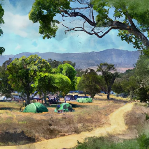
Reservations are accepted at Middle Santa Ynez Campground, allowing campers to secure their spot in advance. This is particularly recommended during peak seasons to guarantee availability. The campground is managed by the Los Padres National Forest, ensuring a high level of maintenance and security.
The best time to visit Middle Santa Ynez Campground is during the spring and fall seasons when the weather is mild and pleasant. However, it is important to note that the campground can get crowded during weekends and holidays. Therefore, arriving early or making a reservation in advance is advisable.
Campers at Middle Santa Ynez Campground can enjoy various activities in the surrounding area. The nearby Santa Ynez River offers opportunities for fishing, swimming, and kayaking. Hiking enthusiasts can explore the scenic trails such as the 2.6-mile Santa Ynez River Trail. It is essential for visitors to be cautious of wildlife in the area and adhere to safety guidelines, such as storing food properly and respecting the natural habitat. Overall, Middle Santa Ynez Campground provides a tranquil camping experience with its amenities and beautiful surroundings, making it an ideal destination for nature lovers.
What's on-site at Middle Santa Ynez Campground
Key facilities Snoflo tracks for this campground. Confirm with the operator before booking -- amenities can change seasonally.
Plan your trip down to the hour
Same weather feed Snoflo's iOS app uses -- updated continuously from NOAA / yr.no.
Next 5 days, hour by hour
Temperature line with weather symbols on top, snow + rain accumulation as columns, humidity as a dotted line.
5-day forecast table
Every 3 hours, broken out across temperature, snow, rain, humidity, and wind. Each cell is colour-coded relative to the column min/max so trends jump out at a glance.
| Time | Condition | Temp (°F) | Snow (in) | Rain (in) | Humidity (%) | Wind (mps) | Wind dir |
|---|---|---|---|---|---|---|---|
| Loading detailed forecast… | |||||||
15-day temperature & precipitation
Daily temperatures, snow, and rain projected over the next two weeks. Hover any point for the full breakdown.
Other campgrounds in the area
Snoflo-tracked campsites within driving distance of Middle Santa Ynez Campground, with reservations status.
| Campground | Reservations | Toilets | View |
|---|---|---|---|
| Middle Santa Ynez | ✗ | ✓ | → |
| P-Bar Flat Campground | ✗ | ✗ | → |
| Upper Caliente Camp | ✗ | ✗ | → |
| Alder Creek Camp | ✗ | ✗ | → |
| Upper Santa Ynez Camp | ✗ | ✗ | → |
Nearby streamflow
USGS streamgauges within reach of Middle Santa Ynez Campground -- pulled live from the National Water Information System.
| Streamgauge | Discharge | View |
|---|---|---|
| Gibraltar Dam Div Weir A Gibraltar Dam Ca | 13 cfs | → |
| Santa Ynez R Bl Gibraltar Dam Nr Snta Brb C Ca | 15 cfs | → |
| Gibralter Dam Rel Wr A Gibralter Dam Ca | 16 cfs | → |
| Mission C A Rnp A Santa Barbara Ca | · | → |
| Carpinteria C Nr Carpinteria Ca | · | → |
| Mission C Nr Mission St Nr Santa Barbara Ca | · | → |
Plan a longer trip
The closest parks, lakes, boat launches, and paddle runs so a camping night can grow into a full weekend.
Parks
- Gould Park
- Toro Canyon Park
- Wilderness Dick Smith
- Lookout Park
- Fleischmann Field
- Rattlesnake Canyon Park
Boat launches
- Santa Barbara Harbor
- Lake Casitas Recreation Area (West) (Coyote Boat)
- Lake Casitas Recreation Area (Santa Ana)
- Santa Ana Road Ventura County
- Cachuma Lake Recreation Area
Fishing spots
Points of interest
Paddle runs
- Chorro Grande Canyon To Section Line Dividing Sec 1, T5n, R23w And Sec 6, T5n, T22w
- Section Line To Confluence With Rock Creek
- Headwaters, Upper Piru Creek To Wildernes Boundary
- Wilderness Boundary To Confluence With Gold Hill Creek
- Confluence With Gold Hill Creek To Castaic
Camping essentials & Leave No Trace
- Pack it in, pack it out
- Take all trash, food scraps, and gear back with you to keep campsites clean and protect wildlife.
- Respect wildlife
- Observe animals from a distance, store food securely, and never feed wildlife to maintain natural behavior and safety.
- Know before you go
- Check weather, fire restrictions, trail conditions, and permit requirements to ensure a safe and well-planned trip.
- Minimize campfire impact
- Use established fire rings, keep fires small, fully extinguish them, or opt for a camp stove when fires are restricted.
- Leave what you find
- Preserve natural and cultural features by avoiding removal of plants, rocks, artifacts, or other elements of the environment.
Set push alerts in the Snoflo app
Save Middle Santa Ynez Campground as a favorite, set a custom threshold (precipitation, snowpack, freezing temperatures), and the iOS app will push the moment conditions cross.
About Middle Santa Ynez Campground
Can I make reservations at Middle Santa Ynez Campground?
This campground does not appear to accept reservations -- it's typically first-come, first-served. Arrive early on summer weekends.
How fresh is the weather data on this page?
The hourly forecast updates throughout the day from the NOAA / yr.no public feeds. Streamflow data is pulled live from USGS streamgauges and snowpack from the NRCS SNOTEL network.
What's the best time of year to visit?
Use the 15-day temperature & precipitation outlook on this page to plan -- pick a window with comfortable temperatures and low precipitation. For longer trips, the 5-day hourly meteogram shows snow + rain accumulation hour-by-hour.
How do I get to Middle Santa Ynez Campground?
Tap Directions in the hero above to open driving directions in Google Maps, or Open in map to center the Snoflo interactive map on the campground.
Can I get alerts when conditions change?
Yes -- alerts are managed through the Snoflo iOS app. Favorite this campground, set a threshold (temperature, snowpack, precipitation), and you'll get a push the moment it crosses.
Other campgrounds near here
Snoflo-tracked campgrounds within driving distance of Middle Santa Ynez Campground.