Winchuck Campground
Community Reviews
Been here? Share the conditions.
Reviews, ratings & photos are added in the free Snoflo iOS app — rate a spot, tag the conditions, and your visit is verified by location. Add or manage your reviews from the app.
Winchuck
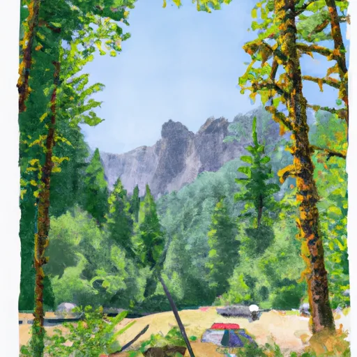
The campground itself offers a range of amenities, including picnic tables, fire rings, and vault toilets. There are 18 campsites available on a first-come, first-serve basis, and RVs up to 16 feet in length are allowed. There are no hookups or showers available at the campground.
An interesting fact about Winchuck Camping Area is that it's located near the Oregon Coast Trail, a 382-mile hiking trail that stretches along the entire length of Oregon's coastline.
The best time to visit Winchuck Camping Area is during the summer months when the weather is warm and dry. Average temperatures during this time are in the mid-60s to low-70s. However, visitors should be prepared for cooler temperatures and possible rain during the shoulder seasons.
What's on-site at Winchuck
Key facilities Snoflo tracks for this campground. Confirm with the operator before booking -- amenities can change seasonally.
Plan your trip down to the hour
Same weather feed Snoflo's iOS app uses -- updated continuously from NOAA / yr.no.
Next 5 days, hour by hour
Temperature line with weather symbols on top, snow + rain accumulation as columns, humidity as a dotted line.
5-day forecast table
Every 3 hours, broken out across temperature, snow, rain, humidity, and wind. Each cell is colour-coded relative to the column min/max so trends jump out at a glance.
| Time | Condition | Temp (°F) | Snow (in) | Rain (in) | Humidity (%) | Wind (mps) | Wind dir |
|---|---|---|---|---|---|---|---|
| Loading detailed forecast… | |||||||
15-day temperature & precipitation
Daily temperatures, snow, and rain projected over the next two weeks. Hover any point for the full breakdown.
Other campgrounds in the area
Snoflo-tracked campsites within driving distance of Winchuck, with reservations status.
| Campground | Reservations | Toilets | View |
|---|---|---|---|
| Ludlum Campground | ✓ | ✗ | → |
| Ludlum | ✗ | ✓ | → |
| Ludlum House Group Site Recreation Rental | ✓ | ✗ | → |
| Apple Hill Rv | ✗ | ✗ | → |
| Clifford Kamph Co Park | ✗ | ✗ | → |
Nearby streamflow
USGS streamgauges within reach of Winchuck -- pulled live from the National Water Information System.
| Streamgauge | Discharge | View |
|---|---|---|
| Chetco River Near Brookings | 76 cfs | → |
| Smith R Nr Crescent City Ca | 294 cfs | → |
| Illinois River Near Kerby | 28 cfs | → |
| Rogue River At Hwy 101 Bridge | 3,580 cfs | → |
| Sucker Cr Bl Lt Grayback Cr Nr Holland | 21 cfs | → |
| Klamath R Nr Klamath Ca | 2,660 cfs | → |
Nearby snow depths
NRCS SNOTEL stations within reach of Winchuck -- relevant when planning a shoulder-season or alpine trip.
| SNOTEL station | Snowpack | 24h Snowfall | View |
|---|---|---|---|
| Nohrsc Bigelow Camp | 0.0 in | 0.0 in | → |
| Bigelow Camp | 0.0 in | 0.0 in | → |
Plan a longer trip
The closest parks, lakes, boat launches, and paddle runs so a camping night can grow into a full weekend.
Parks
- Crissey Field State Recreation Site
- Winchuck State Recreation Site
- Pelican State Beach
- Mcvay Rock State Recreation Site
- Wilderness Kalmiopsis
- Alfred A Loeb State Park
Boat launches
- Salmon Harbor Rv Resort
- Social Security Bar
- Alfred A. Loeb State Park
- Miller Bar Boating Site
- Port Of Brookings Harbor
- Nook Bar Boating Site
Points of interest
- Japanese Bombing Site Trailhead
- Chetco Grange
- Wright's Custom Framing & Art Supplies
- Amphitheater
- Stout Grove
- Grove Of Titans
Paddle runs
- West Section Line Of Sec 31, T40s, R10w To Confluence With North Fork Smith River
- Headwaters And Perennial Tributaries To West Section Line Of Sec 31, T40s, R10w
- West Fork Illinois River
- Headwaters Including Both Unnamed Forks And Rr Lakes To Confluence With Rough And Ready Creek
- Confluence Of North And South Forks Rough And Ready To Middle Of Sec 15, T40s, R9w
- Headwaters To Middle Of Sec 15, T39s, R4e
Camping essentials & Leave No Trace
- Pack it in, pack it out
- Take all trash, food scraps, and gear back with you to keep campsites clean and protect wildlife.
- Respect wildlife
- Observe animals from a distance, store food securely, and never feed wildlife to maintain natural behavior and safety.
- Know before you go
- Check weather, fire restrictions, trail conditions, and permit requirements to ensure a safe and well-planned trip.
- Minimize campfire impact
- Use established fire rings, keep fires small, fully extinguish them, or opt for a camp stove when fires are restricted.
- Leave what you find
- Preserve natural and cultural features by avoiding removal of plants, rocks, artifacts, or other elements of the environment.
Set push alerts in the Snoflo app
Save Winchuck as a favorite, set a custom threshold (precipitation, snowpack, freezing temperatures), and the iOS app will push the moment conditions cross.
About Winchuck
Can I make reservations at Winchuck?
This campground does not appear to accept reservations -- it's typically first-come, first-served. Arrive early on summer weekends.
How fresh is the weather data on this page?
The hourly forecast updates throughout the day from the NOAA / yr.no public feeds. Streamflow data is pulled live from USGS streamgauges and snowpack from the NRCS SNOTEL network.
What's the best time of year to visit?
Use the 15-day temperature & precipitation outlook on this page to plan -- pick a window with comfortable temperatures and low precipitation. For longer trips, the 5-day hourly meteogram shows snow + rain accumulation hour-by-hour.
How do I get to Winchuck?
Tap Directions in the hero above to open driving directions in Google Maps, or Open in map to center the Snoflo interactive map on the campground.
Can I get alerts when conditions change?
Yes -- alerts are managed through the Snoflo iOS app. Favorite this campground, set a threshold (temperature, snowpack, precipitation), and you'll get a push the moment it crosses.
Other campgrounds near here
Snoflo-tracked campgrounds within driving distance of Winchuck.