Miner Lake campground
Community Reviews
Been here? Share the conditions.
Reviews, ratings & photos are added in the free Snoflo iOS app — rate a spot, tag the conditions, and your visit is verified by location. Add or manage your reviews from the app.
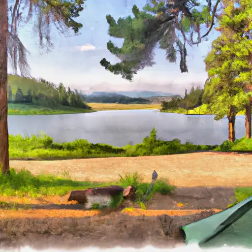
Miner Lake
Reservations are accepted at Miner Lake camping area, allowing visitors to secure their spot in advance. This is highly recommended, especially during peak seasons, to ensure availability. The campground offers both tent and RV camping options, accommodating a wide range of campers.
The best time to visit Miner Lake camping area is during the summer months, from June to September, when the weather is warm and ideal for outdoor activities. During this time, campers can enjoy swimming, fishing, boating, and hiking in the nearby trails. Wildlife enthusiasts will also appreciate the opportunity to observe various species of birds and animals in their natural habitat.
While exploring Miner Lake camping area, it is important to be cautious of the local wildlife, such as bears and mountain lions. Visitors should practice proper food storage techniques and be mindful of their surroundings. Additionally, it is essential to follow all campground rules and regulations to ensure a safe and enjoyable experience for everyone.
In conclusion, Miner Lake camping area in Montana offers a peaceful escape surrounded by nature's beauty. With its amenities, reservation system, and recommended visiting time, it serves as an ideal destination for camping enthusiasts seeking a memorable outdoor experience.
What's on-site at Miner Lake
Key facilities Snoflo tracks for this campground. Confirm with the operator before booking -- amenities can change seasonally.
Plan your trip down to the hour
Same weather feed Snoflo's iOS app uses -- updated continuously from NOAA / yr.no.
Next 5 days, hour by hour
Temperature line with weather symbols on top, snow + rain accumulation as columns, humidity as a dotted line.
5-day forecast table
Every 3 hours, broken out across temperature, snow, rain, humidity, and wind. Each cell is colour-coded relative to the column min/max so trends jump out at a glance.
| Time | Condition | Temp (°F) | Snow (in) | Rain (in) | Humidity (%) | Wind (mps) | Wind dir |
|---|---|---|---|---|---|---|---|
| Loading detailed forecast… | |||||||
15-day temperature & precipitation
Daily temperatures, snow, and rain projected over the next two weeks. Hover any point for the full breakdown.
Other campgrounds in the area
Snoflo-tracked campsites within driving distance of Miner Lake, with reservations status.
| Campground | Reservations | Toilets | View |
|---|---|---|---|
| Miner Lake Campground | ✗ | ✗ | → |
| North Van Houten Campground | ✗ | ✗ | → |
| South Van Houten Campground | ✗ | ✗ | → |
| Van Houten | ✗ | ✓ | → |
| Twin Lakes | ✗ | ✓ | → |
Nearby streamflow
USGS streamgauges within reach of Miner Lake -- pulled live from the National Water Information System.
| Streamgauge | Discharge | View |
|---|---|---|
| Big Hole River Near Jackson Mt | 25 cfs | → |
| Lemhi River Below L5 Diversion Near Salmon | 383 cfs | → |
| Salmon River At Salmon Id | 2,080 cfs | → |
| Big Hole River Bl Big Lake Cr At Wisdom Mt | 99 cfs | → |
| Lemhi River Nr Lemhi Id | 247 cfs | → |
| Napias Creek Below Arnett Creek Near Leesburg | 52 cfs | → |
Nearby snow depths
NRCS SNOTEL stations within reach of Miner Lake -- relevant when planning a shoulder-season or alpine trip.
| SNOTEL station | Snowpack | 24h Snowfall | View |
|---|---|---|---|
| Nohrsc Slagamelt Lakes | 0.0 in | 0.0 in | → |
| Darkhorse Lake | 0.0 in | 0.0 in | → |
| Nohrsc Darkhorse Lake | 0.0 in | 0.0 in | → |
| Bloody Dick | 0.0 in | 0.0 in | → |
| Bloody Dick | 0.0 in | 0.0 in | → |
| Nohrsc Lemhi Ridge | 3.0 in | 0.0 in | → |
Plan a longer trip
The closest parks, lakes, boat launches, and paddle runs so a camping night can grow into a full weekend.
Parks
- Beaverhead-Deerlodge National Forest
- Big Hole National Battlefield
- Bannack State Park
- Wilderness Anaconda Pintler
Boat launches
Fishing spots
Points of interest
- Tower Creek Pirimids Day Use Area
- Kenney Creek
- Sharkey Hot Springs
- Big Hole Visitor Center
- Backcountry Byway Day Use Area
- Westward Overlook - Lemhi Pass Cdt Access
Paddle runs
- Salmon To North Fork
- Nf Boundary At 4th Of July Creek To Confluence With North Fork
- Sec. 29, T.8s, R.13w To All Upstream Waters
- Pattengail Ck. Sec. 11, T2s, R12w To Jaccobsen & Mono Cks, Sec. 33, T3s, R12w
- Proposed Torrey Peak Wilderness To Proposed Torrey Peak Wilderness
- Bear Valley Lake To Trailhead
Camping essentials & Leave No Trace
- Pack it in, pack it out
- Take all trash, food scraps, and gear back with you to keep campsites clean and protect wildlife.
- Respect wildlife
- Observe animals from a distance, store food securely, and never feed wildlife to maintain natural behavior and safety.
- Know before you go
- Check weather, fire restrictions, trail conditions, and permit requirements to ensure a safe and well-planned trip.
- Minimize campfire impact
- Use established fire rings, keep fires small, fully extinguish them, or opt for a camp stove when fires are restricted.
- Leave what you find
- Preserve natural and cultural features by avoiding removal of plants, rocks, artifacts, or other elements of the environment.
Set push alerts in the Snoflo app
Save Miner Lake as a favorite, set a custom threshold (precipitation, snowpack, freezing temperatures), and the iOS app will push the moment conditions cross.
About Miner Lake
Can I make reservations at Miner Lake?
This campground does not appear to accept reservations -- it's typically first-come, first-served. Arrive early on summer weekends.
How fresh is the weather data on this page?
The hourly forecast updates throughout the day from the NOAA / yr.no public feeds. Streamflow data is pulled live from USGS streamgauges and snowpack from the NRCS SNOTEL network.
What's the best time of year to visit?
Use the 15-day temperature & precipitation outlook on this page to plan -- pick a window with comfortable temperatures and low precipitation. For longer trips, the 5-day hourly meteogram shows snow + rain accumulation hour-by-hour.
How do I get to Miner Lake?
Tap Directions in the hero above to open driving directions in Google Maps, or Open in map to center the Snoflo interactive map on the campground.
Can I get alerts when conditions change?
Yes -- alerts are managed through the Snoflo iOS app. Favorite this campground, set a threshold (temperature, snowpack, precipitation), and you'll get a push the moment it crosses.
Other campgrounds near here
Snoflo-tracked campgrounds within driving distance of Miner Lake.