Kreis Pond Campground
Community Reviews
Been here? Share the conditions.
Reviews, ratings & photos are added in the free Snoflo iOS app — rate a spot, tag the conditions, and your visit is verified by location. Add or manage your reviews from the app.
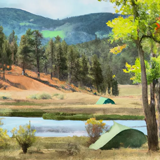
Kreis Pond
Reservations are required to secure a spot at Kreis Pond camping area. It is advisable to book well in advance, as the campground tends to fill up quickly, especially during peak seasons. The best time to visit this camping area is during the summer months, from June to September, when the weather is pleasant and ideal for outdoor activities.
While camping at Kreis Pond, there are several points of interest to explore. The serene pond itself is perfect for fishing enthusiasts, offering opportunities to catch various species of fish. Hiking trails in the surrounding area provide breathtaking views of the Montana wilderness. However, it is important to exercise caution while camping here, as the area is known for bear activity. Campers are advised to store food properly and follow recommended safety protocols to ensure a secure and enjoyable stay.
In conclusion, Kreis Pond camping area in Montana offers a range of amenities, requires reservations, and is best visited between June and September. With its picturesque setting, ample recreational opportunities, and beautiful pond, this camping area provides an unforgettable experience for nature lovers. However, campers should remain cautious about bears and follow safety guidelines to fully enjoy their time in this stunning Montana campground.
What's on-site at Kreis Pond
Key facilities Snoflo tracks for this campground. Confirm with the operator before booking -- amenities can change seasonally.
Plan your trip down to the hour
Same weather feed Snoflo's iOS app uses -- updated continuously from NOAA / yr.no.
Next 5 days, hour by hour
Temperature line with weather symbols on top, snow + rain accumulation as columns, humidity as a dotted line.
5-day forecast table
Every 3 hours, broken out across temperature, snow, rain, humidity, and wind. Each cell is colour-coded relative to the column min/max so trends jump out at a glance.
| Time | Condition | Temp (°F) | Snow (in) | Rain (in) | Humidity (%) | Wind (mps) | Wind dir |
|---|---|---|---|---|---|---|---|
| Loading detailed forecast… | |||||||
15-day temperature & precipitation
Daily temperatures, snow, and rain projected over the next two weeks. Hover any point for the full breakdown.
Other campgrounds in the area
Snoflo-tracked campsites within driving distance of Kreis Pond, with reservations status.
| Campground | Reservations | Toilets | View |
|---|---|---|---|
| Kreis Pond Campground | ✓ | ✗ | → |
| Ccc Campsite | ✗ | ✗ | → |
| Petty Creek Fas | ✗ | ✗ | → |
| Big Pine Fishing Access | ✗ | ✗ | → |
| Big Pine Fas | ✗ | ✓ | → |
Nearby streamflow
USGS streamgauges within reach of Kreis Pond -- pulled live from the National Water Information System.
| Streamgauge | Discharge | View |
|---|---|---|
| Flathead River At Perma Mt | 9,240 cfs | → |
| Clark Fork Below Missoula Mt | 2,990 cfs | → |
| Bitterroot River Near Missoula Mt | 921 cfs | → |
| Mission Cr Ab Reservoir Nr St Ignatius Mt | 111 cfs | → |
| South Fork Jocko River Near Arlee Mt | 54 cfs | → |
| Clark Fork Above Missoula Mt | 2,060 cfs | → |
Nearby snow depths
NRCS SNOTEL stations within reach of Kreis Pond -- relevant when planning a shoulder-season or alpine trip.
| SNOTEL station | Snowpack | 24h Snowfall | View |
|---|---|---|---|
| Nohrsc Sleeping Woman | 0.0 in | 0.0 in | → |
| Sleeping Woman | 0.0 in | 0.0 in | → |
| Alberton | 0.0 in | 0.0 in | → |
| Missoula 6 Nw Wfo | 0.0 in | 0.0 in | → |
| Missoula | 0.0 in | 0.0 in | → |
| Missoula 4.4 W | 0.0 in | 0.0 in | → |
Plan a longer trip
The closest parks, lakes, boat launches, and paddle runs so a camping night can grow into a full weekend.
Parks
- Frenchtown Pond State Park
- Fish Creek State Park
- National Bison Range National Wildlife Refuge
- Council Grove State Park
- Missoula Memorial Rose Garden
- Greenough Park
Boat launches
- Southside Road Missoula County
- St. John's
- Deep Creek
- Harper's Bridge
- Forest Grove
- I 90 Mineral County
Fishing spots
- Petty Creek Fishing Access
- St. John's Fishing Access Site
- Deep Creek Fishing Access
- Tarkio Fishing Access
- Bitterroot River
- Blacktail Lake
Points of interest
- Petty Creek Bighorn Sheep Viewing Site
- National Museum Of Forest Service History
- National Bison Range
- Mineral County Museum
- Historical Museum At Fort Missoula
- E3 Convergance Gallery
Paddle runs
- Alberton Gorge (St. John To Forrest Grove)
- West Fork Fish Creek Headwaters, Sec. 6, T13n, R26w To Clearwater Crossing Trailhead, Sec. 6, T13n, R25w
- Montana Creek, Sec. 18, T11n, R24w To Fish Creek, Sec. 8, T12n, R24w
- Mainstem Headwaters, Sec. 21, T11n, R25w To Montana Creek, Sec. 18, T12n, R24w
- Spring Gulch Headwaters, Sec. 12, T14n, R19w To Mainstem, Sec. 35, T14n, R19w
- Wrangle Creek Headwaters, Sec. 18, T15n, R18w To Mainstem, Sec. 21, T15n, R18w
Camping essentials & Leave No Trace
- Pack it in, pack it out
- Take all trash, food scraps, and gear back with you to keep campsites clean and protect wildlife.
- Respect wildlife
- Observe animals from a distance, store food securely, and never feed wildlife to maintain natural behavior and safety.
- Know before you go
- Check weather, fire restrictions, trail conditions, and permit requirements to ensure a safe and well-planned trip.
- Minimize campfire impact
- Use established fire rings, keep fires small, fully extinguish them, or opt for a camp stove when fires are restricted.
- Leave what you find
- Preserve natural and cultural features by avoiding removal of plants, rocks, artifacts, or other elements of the environment.
Set push alerts in the Snoflo app
Save Kreis Pond as a favorite, set a custom threshold (precipitation, snowpack, freezing temperatures), and the iOS app will push the moment conditions cross.
About Kreis Pond
Can I make reservations at Kreis Pond?
This campground does not appear to accept reservations -- it's typically first-come, first-served. Arrive early on summer weekends.
How fresh is the weather data on this page?
The hourly forecast updates throughout the day from the NOAA / yr.no public feeds. Streamflow data is pulled live from USGS streamgauges and snowpack from the NRCS SNOTEL network.
What's the best time of year to visit?
Use the 15-day temperature & precipitation outlook on this page to plan -- pick a window with comfortable temperatures and low precipitation. For longer trips, the 5-day hourly meteogram shows snow + rain accumulation hour-by-hour.
How do I get to Kreis Pond?
Tap Directions in the hero above to open driving directions in Google Maps, or Open in map to center the Snoflo interactive map on the campground.
Can I get alerts when conditions change?
Yes -- alerts are managed through the Snoflo iOS app. Favorite this campground, set a threshold (temperature, snowpack, precipitation), and you'll get a push the moment it crosses.
Other campgrounds near here
Snoflo-tracked campgrounds within driving distance of Kreis Pond.