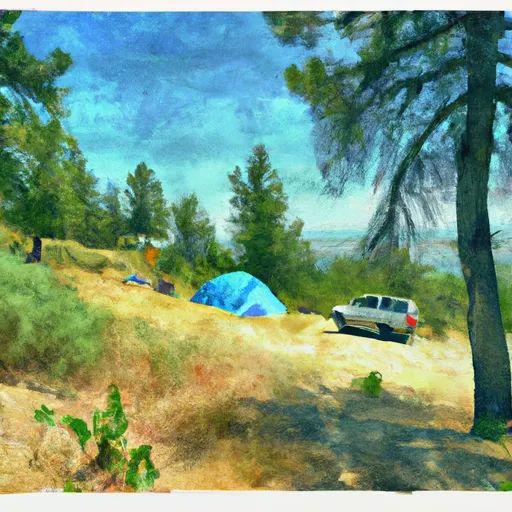
Wood Bottom Campground
Community Reviews
Been here? Share the conditions.
Reviews, ratings & photos are added in the free Snoflo iOS app — rate a spot, tag the conditions, and your visit is verified by location. Add or manage your reviews from the app.
Wood Bottom
The nearby points of interest include the Missouri River, which is a popular spot for fishing and boating. Additionally, visitors can explore the Lewis and Clark National Forest, which offers beautiful views of the mountains and forests.
The campground amenities include picnic tables, fire pits, and vault toilets. Water is available, but visitors are advised to bring their own drinking water. The campground is open from May through September.
Interesting facts about the area include its historical significance as a route taken by Lewis and Clark during their expedition. The area is also home to a variety of wildlife such as elk, deer, and black bears.
The best time of year to visit the Wood Bottom Campground is during the summer months, with average temperatures ranging from the mid-70s to mid-80s Fahrenheit. However, visitors should be prepared for sudden changes in weather and should check the forecast before heading out.
Sources:
- https://www.recreation.gov/camping/campgrounds/232423
- https://www.fs.usda.gov/recarea/lcnf/recarea/?recid=6130
- https://www.visitmt.com/places-to-go/parks-and-recreation/campgrounds/wood-bottom-campground.html
What's on-site at Wood Bottom
Key facilities Snoflo tracks for this campground. Confirm with the operator before booking -- amenities can change seasonally.
Plan your trip down to the hour
Same weather feed Snoflo's iOS app uses -- updated continuously from NOAA / yr.no.
Next 5 days, hour by hour
Temperature line with weather symbols on top, snow + rain accumulation as columns, humidity as a dotted line.
5-day forecast table
Every 3 hours, broken out across temperature, snow, rain, humidity, and wind. Each cell is colour-coded relative to the column min/max so trends jump out at a glance.
| Time | Condition | Temp (°F) | Snow (in) | Rain (in) | Humidity (%) | Wind (mps) | Wind dir |
|---|---|---|---|---|---|---|---|
| Loading detailed forecast… | |||||||
15-day temperature & precipitation
Daily temperatures, snow, and rain projected over the next two weeks. Hover any point for the full breakdown.
Other campgrounds in the area
Snoflo-tracked campsites within driving distance of Wood Bottom, with reservations status.
| Campground | Reservations | Toilets | View |
|---|---|---|---|
| Wood Bottom Recreation Area - Umrbnm | ✗ | ✗ | → |
| Wood Bottom Recreation Area | ✗ | ✗ | → |
| Black Bluff Rapids | ✗ | ✗ | → |
| Seineurs Reach | ✗ | ✗ | → |
| Evans Bend | ✗ | ✗ | → |
Nearby streamflow
USGS streamgauges within reach of Wood Bottom -- pulled live from the National Water Information System.
| Streamgauge | Discharge | View |
|---|---|---|
| Teton River At Loma Mt | 13 cfs | → |
| Marias River Near Loma Mt | 1,400 cfs | → |
| Missouri River At Fort Benton Mt | 5,410 cfs | → |
| Missouri River At Virgelle Mt | 6,250 cfs | → |
| Missouri River Near Great Falls Mt | 4,450 cfs | → |
| Marias River Near Chester Mt | 1,550 cfs | → |
Nearby snow depths
NRCS SNOTEL stations within reach of Wood Bottom -- relevant when planning a shoulder-season or alpine trip.
| SNOTEL station | Snowpack | 24h Snowfall | View |
|---|---|---|---|
| Loma | 0.0 in | 0.0 in | → |
| Fort Benton | 0.0 in | 0.0 in | → |
| Big Sandy Se | 0.0 in | 0.0 in | → |
| Inverness S | 0.0 in | 0.0 in | → |
| Nohrsc Chester 10.5 S | 0.0 in | 0.0 in | → |
| Brady 27 Ene (The Knees) | 0.0 in | 0.0 in | → |
Plan a longer trip
The closest parks, lakes, boat launches, and paddle runs so a camping night can grow into a full weekend.
Boat launches
- Wood Bottom Recreation Area
- Loma Bridge
- Seineurs Reach
- Coal Banks Landing
- Lone Tree Coulee
- Little Sandy Coulee Rec Site
Fishing spots
Camping essentials & Leave No Trace
- Pack it in, pack it out
- Take all trash, food scraps, and gear back with you to keep campsites clean and protect wildlife.
- Respect wildlife
- Observe animals from a distance, store food securely, and never feed wildlife to maintain natural behavior and safety.
- Know before you go
- Check weather, fire restrictions, trail conditions, and permit requirements to ensure a safe and well-planned trip.
- Minimize campfire impact
- Use established fire rings, keep fires small, fully extinguish them, or opt for a camp stove when fires are restricted.
- Leave what you find
- Preserve natural and cultural features by avoiding removal of plants, rocks, artifacts, or other elements of the environment.
Set push alerts in the Snoflo app
Save Wood Bottom as a favorite, set a custom threshold (precipitation, snowpack, freezing temperatures), and the iOS app will push the moment conditions cross.
About Wood Bottom
Can I make reservations at Wood Bottom?
This campground does not appear to accept reservations -- it's typically first-come, first-served. Arrive early on summer weekends.
How fresh is the weather data on this page?
The hourly forecast updates throughout the day from the NOAA / yr.no public feeds. Streamflow data is pulled live from USGS streamgauges and snowpack from the NRCS SNOTEL network.
What's the best time of year to visit?
Use the 15-day temperature & precipitation outlook on this page to plan -- pick a window with comfortable temperatures and low precipitation. For longer trips, the 5-day hourly meteogram shows snow + rain accumulation hour-by-hour.
How do I get to Wood Bottom?
Tap Directions in the hero above to open driving directions in Google Maps, or Open in map to center the Snoflo interactive map on the campground.
Can I get alerts when conditions change?
Yes -- alerts are managed through the Snoflo iOS app. Favorite this campground, set a threshold (temperature, snowpack, precipitation), and you'll get a push the moment it crosses.
Other campgrounds near here
Snoflo-tracked campgrounds within driving distance of Wood Bottom.