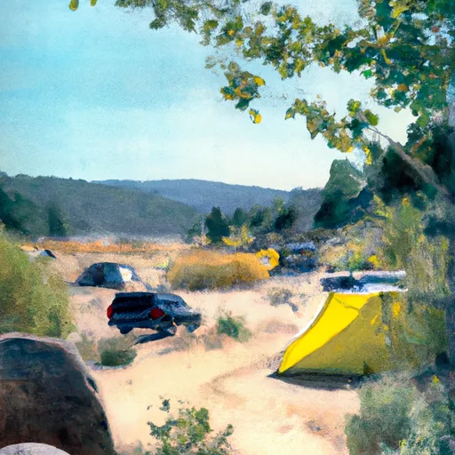
Shirttail Campground
Community Reviews
Been here? Share the conditions.
Reviews, ratings & photos are added in the free Snoflo iOS app — rate a spot, tag the conditions, and your visit is verified by location. Add or manage your reviews from the app.
Shirttail
Reservations are accepted at Shirttail camping area, allowing visitors to secure their spot in advance. This feature proves especially beneficial during peak seasons when the campground may experience higher demand. It is recommended to check the reservation policy and make necessary arrangements beforehand to ensure a hassle-free visit.
The best time to visit Shirttail camping area is during the warmer months, typically from late spring to early fall, when the weather is pleasant for outdoor activities. Campers can enjoy various recreational opportunities such as fishing, hiking, and wildlife spotting in the surrounding areas. However, it is important to note that during winter or rainy seasons, certain areas of the campground might be prone to flooding or become inaccessible, so it is advisable to check weather conditions and campground status before planning a trip.
In summary, Shirttail camping area in California offers a well-equipped campground with amenities such as restrooms, picnic areas, and potable water. Reservations are accepted, ensuring a convenient camping experience. It is best to visit during the warmer months and engage in various outdoor activities. However, it is essential to stay informed about the weather conditions and campground accessibility to avoid any potential issues during the visit.
What's on-site at Shirttail
Key facilities Snoflo tracks for this campground. Confirm with the operator before booking -- amenities can change seasonally.
Plan your trip down to the hour
Same weather feed Snoflo's iOS app uses -- updated continuously from NOAA / yr.no.
Next 5 days, hour by hour
Temperature line with weather symbols on top, snow + rain accumulation as columns, humidity as a dotted line.
5-day forecast table
Every 3 hours, broken out across temperature, snow, rain, humidity, and wind. Each cell is colour-coded relative to the column min/max so trends jump out at a glance.
| Time | Condition | Temp (°F) | Snow (in) | Rain (in) | Humidity (%) | Wind (mps) | Wind dir |
|---|---|---|---|---|---|---|---|
| Loading detailed forecast… | |||||||
15-day temperature & precipitation
Daily temperatures, snow, and rain projected over the next two weeks. Hover any point for the full breakdown.
Other campgrounds in the area
Snoflo-tracked campsites within driving distance of Shirttail, with reservations status.
| Campground | Reservations | Toilets | View |
|---|---|---|---|
| Shirttail Campground | ✓ | ✗ | → |
| Giant Gap | ✓ | ✓ | → |
| Giant Gap Campground | ✓ | ✗ | → |
| Forbes Group Campground | ✓ | ✗ | → |
| Big Reservoir Campground | ✓ | ✗ | → |
Nearby streamflow
USGS streamgauges within reach of Shirttail -- pulled live from the National Water Information System.
| Streamgauge | Discharge | View |
|---|---|---|
| Pilot C Bl Mutton Canyon Nr Georgetown Ca | 2 cfs | → |
| Nf American R A North Fork Dam Ca | 63 cfs | → |
| Pilot C Ab Stumpy Meadows Res Ca | 3 cfs | → |
| Deer C Nr Smartville Ca | 10 cfs | → |
| N Yuba R Bl Goodyears Bar Ca | 142 cfs | → |
| Donner C A Donner Lk Nr Truckee Ca | 5 cfs | → |
Nearby snow depths
NRCS SNOTEL stations within reach of Shirttail -- relevant when planning a shoulder-season or alpine trip.
| SNOTEL station | Snowpack | 24h Snowfall | View |
|---|---|---|---|
| Blue Canyon Alert | 0.0 in | 0.0 in | → |
| Blue Canyon | 21.0 in | 3.0 in | → |
| Grass Valley No. 2 | 0.0 in | 0.0 in | → |
| Nohrsc Meadow Lk Snow Course | 21.2 in | 0.2 in | → |
| Soda Springs 1.5 Ssw | 0.0 in | 0.0 in | → |
| Nohrsc Css Lab | 0.0 in | 0.0 in | → |
Plan a longer trip
The closest parks, lakes, boat launches, and paddle runs so a camping night can grow into a full weekend.
Parks
- Empire Mine State Historic Park
- Malakoff Diggins State Historic Park
- Kalithea Park
- Condon Park
- Devere Mautino Community Park
- Meadow Vista Park
Boat launches
- Iowa Hill Road Placer County
- Rollins Lake
- Peninsula Camping And Boating Resort
- Orchard Springs Resort
- Greenhorn Campground
- Oxbow Raft Put-In Site
Fishing spots
- Lake Rollins
- Scotts Flat Lake
- Lake Combie
- Lake Of The Pines
- French Meadows Reservoir
- Lake Clementine
Points of interest
- Cave
- Mountain Shadows Resort
- Heritage Museum
- Alpha Omega Observation Site
- Washington Overlook Observation Site
- Nevada County Narrow Guage Railroad Museum
Paddle runs
- Chamberlain Falls (Iowa Hill To Yankee Jim)
- Yankee Jim Road To Ponderosa Way (Shirttail)
- Tunnel Run (Ralston Powerhouse To Greenwood)
- Generation And Giant Gaps (Tadpole To Colfax-Iowa Hill Road)
- Interbay To Oxbow (End Of The World)
- One-Half Mile West Of Confluence With Fall Creek To Confluence With Jefferson Creek
Camping essentials & Leave No Trace
- Pack it in, pack it out
- Take all trash, food scraps, and gear back with you to keep campsites clean and protect wildlife.
- Respect wildlife
- Observe animals from a distance, store food securely, and never feed wildlife to maintain natural behavior and safety.
- Know before you go
- Check weather, fire restrictions, trail conditions, and permit requirements to ensure a safe and well-planned trip.
- Minimize campfire impact
- Use established fire rings, keep fires small, fully extinguish them, or opt for a camp stove when fires are restricted.
- Leave what you find
- Preserve natural and cultural features by avoiding removal of plants, rocks, artifacts, or other elements of the environment.
Set push alerts in the Snoflo app
Save Shirttail as a favorite, set a custom threshold (precipitation, snowpack, freezing temperatures), and the iOS app will push the moment conditions cross.
About Shirttail
Can I make reservations at Shirttail?
Yes -- this campground accepts reservations. Snoflo recommends booking early for peak season; check the operator (Recreation.gov / state park system / private operator) for the booking window and cancellation policy.
How fresh is the weather data on this page?
The hourly forecast updates throughout the day from the NOAA / yr.no public feeds. Streamflow data is pulled live from USGS streamgauges and snowpack from the NRCS SNOTEL network.
What's the best time of year to visit?
Use the 15-day temperature & precipitation outlook on this page to plan -- pick a window with comfortable temperatures and low precipitation. For longer trips, the 5-day hourly meteogram shows snow + rain accumulation hour-by-hour.
How do I get to Shirttail?
Tap Directions in the hero above to open driving directions in Google Maps, or Open in map to center the Snoflo interactive map on the campground.
Can I get alerts when conditions change?
Yes -- alerts are managed through the Snoflo iOS app. Favorite this campground, set a threshold (temperature, snowpack, precipitation), and you'll get a push the moment it crosses.
Other campgrounds near here
Snoflo-tracked campgrounds within driving distance of Shirttail.