Wallowa Lake State Park Campground
Community Reviews
Been here? Share the conditions.
Reviews, ratings & photos are added in the free Snoflo iOS app — rate a spot, tag the conditions, and your visit is verified by location. Add or manage your reviews from the app.
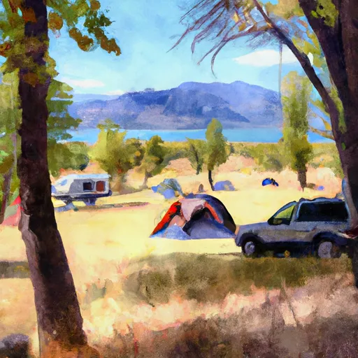
Wallowa Lake State Park
The campground itself offers a range of amenities, including electrical and water hookups, hot showers, and a dump station. The camping area is available on a first-come, first-served basis, and there are a total of 121 campsites available, including 89 electrical sites and 32 non-electrical sites. An interesting fact about the area is that it was formed by a glacier and is over 300 feet deep, making it one of the deepest lakes in Oregon.
The best time to visit Wallowa Lake State Park Camping Area is during the summer months when temperatures are between 75-85 degrees Fahrenheit. Visitors can enjoy warm days and cool nights, making it an ideal time for camping and outdoor activities. Overall, this camping area is a must-visit destination for anyone looking to experience the natural beauty of Oregon.
What's on-site at Wallowa Lake State Park
Key facilities Snoflo tracks for this campground. Confirm with the operator before booking -- amenities can change seasonally.
Plan your trip down to the hour
Same weather feed Snoflo's iOS app uses -- updated continuously from NOAA / yr.no.
Next 5 days, hour by hour
Temperature line with weather symbols on top, snow + rain accumulation as columns, humidity as a dotted line.
5-day forecast table
Every 3 hours, broken out across temperature, snow, rain, humidity, and wind. Each cell is colour-coded relative to the column min/max so trends jump out at a glance.
| Time | Condition | Temp (°F) | Snow (in) | Rain (in) | Humidity (%) | Wind (mps) | Wind dir |
|---|---|---|---|---|---|---|---|
| Loading detailed forecast… | |||||||
15-day temperature & precipitation
Daily temperatures, snow, and rain projected over the next two weeks. Hover any point for the full breakdown.
Other campgrounds in the area
Snoflo-tracked campsites within driving distance of Wallowa Lake State Park, with reservations status.
| Campground | Reservations | Toilets | View |
|---|---|---|---|
| Scenic Meadows Rv And Tent Park | ✗ | ✗ | → |
| Park At The River | ✗ | ✗ | → |
| Biker/Hiker | ✗ | ✗ | → |
| Six Mile Meadow | ✗ | ✗ | → |
| Hurricane Creek | ✗ | ✓ | → |
Nearby streamflow
USGS streamgauges within reach of Wallowa Lake State Park -- pulled live from the National Water Information System.
| Streamgauge | Discharge | View |
|---|---|---|
| Snake River At Hells Canyon Dam Id-Or State Line | 19,200 cfs | → |
| Imnaha River At Imnaha | 150 cfs | → |
| Minam River Near Minam | 124 cfs | → |
| Little Salmon River At Riggins Id | 253 cfs | → |
| Grande Ronde River At Troy | 510 cfs | → |
| Snake River Bl Mcduff Rapids At China Gardens | 16,100 cfs | → |
Nearby snow depths
NRCS SNOTEL stations within reach of Wallowa Lake State Park -- relevant when planning a shoulder-season or alpine trip.
| SNOTEL station | Snowpack | 24h Snowfall | View |
|---|---|---|---|
| Nohrsc Mt. Howard | 1.0 in | 0.0 in | → |
| Mt. Howard | 0.0 in | 0.0 in | → |
| Nohrsc Aneroid Lake #2 | 0.0 in | 0.0 in | → |
| Aneroid Lake #2 | 0.0 in | 0.0 in | → |
| Joseph | 0.0 in | 0.0 in | → |
| Schneider Meadows | 0.0 in | 0.0 in | → |
Plan a longer trip
The closest parks, lakes, boat launches, and paddle runs so a camping night can grow into a full weekend.
Parks
- Wallowa Lake State Park
- Iwetemlaykin State Heritage Site
- National Wild And Scenic River Eagle Creek, Oregon (Wallowa-Whitman Nf)
- Wilderness Hells Canyon
- National Wild And Scenic River Snake, Idaho And Oregon
- Catherine Creek State Park
Fishing spots
Camping essentials & Leave No Trace
- Pack it in, pack it out
- Take all trash, food scraps, and gear back with you to keep campsites clean and protect wildlife.
- Respect wildlife
- Observe animals from a distance, store food securely, and never feed wildlife to maintain natural behavior and safety.
- Know before you go
- Check weather, fire restrictions, trail conditions, and permit requirements to ensure a safe and well-planned trip.
- Minimize campfire impact
- Use established fire rings, keep fires small, fully extinguish them, or opt for a camp stove when fires are restricted.
- Leave what you find
- Preserve natural and cultural features by avoiding removal of plants, rocks, artifacts, or other elements of the environment.
Set push alerts in the Snoflo app
Save Wallowa Lake State Park as a favorite, set a custom threshold (precipitation, snowpack, freezing temperatures), and the iOS app will push the moment conditions cross.
About Wallowa Lake State Park
Can I make reservations at Wallowa Lake State Park?
Yes -- this campground accepts reservations. Snoflo recommends booking early for peak season; check the operator (Recreation.gov / state park system / private operator) for the booking window and cancellation policy.
How fresh is the weather data on this page?
The hourly forecast updates throughout the day from the NOAA / yr.no public feeds. Streamflow data is pulled live from USGS streamgauges and snowpack from the NRCS SNOTEL network.
What's the best time of year to visit?
Use the 15-day temperature & precipitation outlook on this page to plan -- pick a window with comfortable temperatures and low precipitation. For longer trips, the 5-day hourly meteogram shows snow + rain accumulation hour-by-hour.
How do I get to Wallowa Lake State Park?
Tap Directions in the hero above to open driving directions in Google Maps, or Open in map to center the Snoflo interactive map on the campground.
Can I get alerts when conditions change?
Yes -- alerts are managed through the Snoflo iOS app. Favorite this campground, set a threshold (temperature, snowpack, precipitation), and you'll get a push the moment it crosses.
Other campgrounds near here
Snoflo-tracked campgrounds within driving distance of Wallowa Lake State Park.