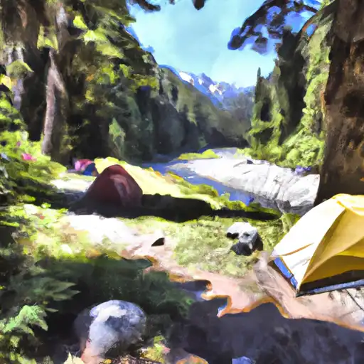
Troublesome Creek Campground
Community Reviews
Been here? Share the conditions.
Reviews, ratings & photos are added in the free Snoflo iOS app — rate a spot, tag the conditions, and your visit is verified by location. Add or manage your reviews from the app.
Troublesome Creek
The campground offers a range of amenities, including picnic tables, fire pits, potable water, and vault toilets. There are 15 campsites available, and reservations are recommended, though some sites are available on a first-come, first-served basis. One interesting fact about the area is that Troublesome Creek is named after a group of miners who had a difficult time finding gold in the area.
The best time of year to visit Troublesome Creek Camping Area is during the summer months when the temperatures are comfortable, ranging from 60-80°F. However, the fall season can also be a great time to visit, with cooler temperatures and stunning fall foliage. Visitors should note that the area can experience heavy snowfall during the winter months, making it difficult to access the campground.
What's on-site at Troublesome Creek
Key facilities Snoflo tracks for this campground. Confirm with the operator before booking -- amenities can change seasonally.
Plan your trip down to the hour
Same weather feed Snoflo's iOS app uses -- updated continuously from NOAA / yr.no.
Next 5 days, hour by hour
Temperature line with weather symbols on top, snow + rain accumulation as columns, humidity as a dotted line.
5-day forecast table
Every 3 hours, broken out across temperature, snow, rain, humidity, and wind. Each cell is colour-coded relative to the column min/max so trends jump out at a glance.
| Time | Condition | Temp (°F) | Snow (in) | Rain (in) | Humidity (%) | Wind (mps) | Wind dir |
|---|---|---|---|---|---|---|---|
| Loading detailed forecast… | |||||||
15-day temperature & precipitation
Daily temperatures, snow, and rain projected over the next two weeks. Hover any point for the full breakdown.
Other campgrounds in the area
Snoflo-tracked campsites within driving distance of Troublesome Creek, with reservations status.
| Campground | Reservations | Toilets | View |
|---|---|---|---|
| Troublesome Creek Campground | ✗ | ✗ | → |
| San Juan | ✗ | ✓ | → |
| Monte Cristo | ✗ | ✗ | → |
| Sauk River Campground | ✗ | ✗ | → |
| Hops Hill Campground | ✗ | ✗ | → |
Nearby streamflow
USGS streamgauges within reach of Troublesome Creek -- pulled live from the National Water Information System.
| Streamgauge | Discharge | View |
|---|---|---|
| South Fork Sultan River Near Sultan | 10 cfs | → |
| Skykomish River Near Gold Bar | 634 cfs | → |
| South Fork Tolt River Near Index | 4 cfs | → |
| Sultan River Below Diversion Dam Near Sultan | 106 cfs | → |
| Sauk River Ab Whitechuck River Near Darrington | 302 cfs | → |
| Sultan River Below Powerplant Near Sultan | 310 cfs | → |
Nearby snow depths
NRCS SNOTEL stations within reach of Troublesome Creek -- relevant when planning a shoulder-season or alpine trip.
| SNOTEL station | Snowpack | 24h Snowfall | View |
|---|---|---|---|
| Alpine Meadows | 1.0 in | 0.0 in | → |
| Nohrsc Alpine Meadows | 1.0 in | 0.0 in | → |
| Stevens Pass - Grace Lakes | 5.9 in | 0.0 in | → |
| Skookum Creek | 0.0 in | 0.0 in | → |
| Skookum Creek | 0.0 in | 0.0 in | → |
| Stevens Pass | 0.0 in | -1.0 in | → |
Plan a longer trip
The closest parks, lakes, boat launches, and paddle runs so a camping night can grow into a full weekend.
Parks
- National Wild And Scenic River Skagit, Washington
- Wallace Falls State Park
- Wilderness Wild Sky
- Wilderness Boulder River
- Henry M Jackson Wilderness
- Mount Pilchuck State Park
Boat launches
- South Shore Road Snohomish County
- White Chuck Boat Launch
- Stevens Pass Highway Sultan
- King County
- Ben Howard Road 21101-21283, Monroe
- Middle Shore Road 2998, Lake Roesiger
Points of interest
Paddle runs
- Headwaters At Outlet Of Blanca Lake To Usfs Road 63
- Usfs Road 63 To Confluence With North Fork Skykomish River
- End Of Usfs Road 63 To Confluence With Troublesome Creek
- Bridge To Confluence With North Fork Skykomish River
- Headwaters In Nw 1/4 Of Sec 30, T29n, R14e To End Of Usfs Road 63 In Nw1/4 Of Sec 10, T28n, R12e
- Headwaters In Ne1/4 Of Sec 13, T28n, R12e To Bridge In Sec 21, T28n, R12e
Camping essentials & Leave No Trace
- Pack it in, pack it out
- Take all trash, food scraps, and gear back with you to keep campsites clean and protect wildlife.
- Respect wildlife
- Observe animals from a distance, store food securely, and never feed wildlife to maintain natural behavior and safety.
- Know before you go
- Check weather, fire restrictions, trail conditions, and permit requirements to ensure a safe and well-planned trip.
- Minimize campfire impact
- Use established fire rings, keep fires small, fully extinguish them, or opt for a camp stove when fires are restricted.
- Leave what you find
- Preserve natural and cultural features by avoiding removal of plants, rocks, artifacts, or other elements of the environment.
Set push alerts in the Snoflo app
Save Troublesome Creek as a favorite, set a custom threshold (precipitation, snowpack, freezing temperatures), and the iOS app will push the moment conditions cross.
About Troublesome Creek
Can I make reservations at Troublesome Creek?
Yes -- this campground accepts reservations. Snoflo recommends booking early for peak season; check the operator (Recreation.gov / state park system / private operator) for the booking window and cancellation policy.
How fresh is the weather data on this page?
The hourly forecast updates throughout the day from the NOAA / yr.no public feeds. Streamflow data is pulled live from USGS streamgauges and snowpack from the NRCS SNOTEL network.
What's the best time of year to visit?
Use the 15-day temperature & precipitation outlook on this page to plan -- pick a window with comfortable temperatures and low precipitation. For longer trips, the 5-day hourly meteogram shows snow + rain accumulation hour-by-hour.
How do I get to Troublesome Creek?
Tap Directions in the hero above to open driving directions in Google Maps, or Open in map to center the Snoflo interactive map on the campground.
Can I get alerts when conditions change?
Yes -- alerts are managed through the Snoflo iOS app. Favorite this campground, set a threshold (temperature, snowpack, precipitation), and you'll get a push the moment it crosses.
Other campgrounds near here
Snoflo-tracked campgrounds within driving distance of Troublesome Creek.