Albion Basin Campground
Community Reviews
Been here? Share the conditions.
Reviews, ratings & photos are added in the free Snoflo iOS app — rate a spot, tag the conditions, and your visit is verified by location. Add or manage your reviews from the app.
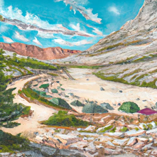
Albion Basin
Reservations are required to secure a campsite at Albion Basin, and it is recommended to book well in advance due to the popularity of the area. The campground is managed by the Alta Ski Area, and their website provides up-to-date information on availability and booking procedures.
The best time of year to visit Albion Basin is from mid-July to early September when the wildflowers are in full bloom, creating a picturesque landscape. This is also the period when the campground is open and accessible. It is worth noting that the campsite is situated at an elevation of over 9,500 feet, so visitors should be prepared for cooler temperatures and potentially rapid weather changes.
Aside from the beautiful scenery, Albion Basin offers various activities for outdoor enthusiasts. Hiking trails in the area provide opportunities to explore the surrounding mountains and enjoy breathtaking views. Visitors should be cautious of the local wildlife, including moose and black bears, and take the necessary precautions to ensure their safety. Additionally, respecting the natural environment and adhering to Leave No Trace principles is crucial in preserving the pristine beauty of Albion Basin.
What's on-site at Albion Basin
Key facilities Snoflo tracks for this campground. Confirm with the operator before booking -- amenities can change seasonally.
Plan your trip down to the hour
Same weather feed Snoflo's iOS app uses -- updated continuously from NOAA / yr.no.
Next 5 days, hour by hour
Temperature line with weather symbols on top, snow + rain accumulation as columns, humidity as a dotted line.
5-day forecast table
Every 3 hours, broken out across temperature, snow, rain, humidity, and wind. Each cell is colour-coded relative to the column min/max so trends jump out at a glance.
| Time | Condition | Temp (°F) | Snow (in) | Rain (in) | Humidity (%) | Wind (mps) | Wind dir |
|---|---|---|---|---|---|---|---|
| Loading detailed forecast… | |||||||
15-day temperature & precipitation
Daily temperatures, snow, and rain projected over the next two weeks. Hover any point for the full breakdown.
Other campgrounds in the area
Snoflo-tracked campsites within driving distance of Albion Basin, with reservations status.
| Campground | Reservations | Toilets | View |
|---|---|---|---|
| Albion Basin Campground | ✓ | ✗ | → |
| Brighton Lds Girls Camp | ✗ | ✗ | → |
| Redman | ✓ | ✓ | → |
| Redman Campground-Slrd | ✓ | ✗ | → |
| Camp Cloud Rim | ✗ | ✗ | → |
Nearby streamflow
USGS streamgauges within reach of Albion Basin -- pulled live from the National Water Information System.
| Streamgauge | Discharge | View |
|---|---|---|
| Mcleod Creek Near Park City | 8 cfs | → |
| Provo River At River Road Bridge | 194 cfs | → |
| American Fk Ab Upper Powerplant Nr American Fk | 21 cfs | → |
| Snake Creek Near Charleston | 24 cfs | → |
| Provo River Near Charleston | 234 cfs | → |
| Daniels Creek At Charleston | · | → |
Nearby snow depths
NRCS SNOTEL stations within reach of Albion Basin -- relevant when planning a shoulder-season or alpine trip.
| SNOTEL station | Snowpack | 24h Snowfall | View |
|---|---|---|---|
| Alta - Collins | 0.0 in | 0.0 in | → |
| Alta | 0.0 in | 0.0 in | → |
| Alta - Guard House | 0.0 in | 0.0 in | → |
| Atwater Study Plot | 0.0 in | 0.0 in | → |
| Nohrsc Atwater | 1.0 in | 0.0 in | → |
| Solitude Summit | 11.1 in | 0.0 in | → |
Plan a longer trip
The closest parks, lakes, boat launches, and paddle runs so a camping night can grow into a full weekend.
Parks
- Wilderness Twin Peaks
- Glacio Park
- Bair Park
- Jordanelle State Park
- Bywater Park
- Dimple Dell Regional Park
Boat launches
- Deer Creek State Park- Charleston Day Use Area
- State Route 319 Wasatch County
- Jordanelle State Park - Hailstone North
- Deer Creek Island
- State Route 314 Wasatch County
- Rock Cliff Boat Ramp
Fishing spots
Camping essentials & Leave No Trace
- Pack it in, pack it out
- Take all trash, food scraps, and gear back with you to keep campsites clean and protect wildlife.
- Respect wildlife
- Observe animals from a distance, store food securely, and never feed wildlife to maintain natural behavior and safety.
- Know before you go
- Check weather, fire restrictions, trail conditions, and permit requirements to ensure a safe and well-planned trip.
- Minimize campfire impact
- Use established fire rings, keep fires small, fully extinguish them, or opt for a camp stove when fires are restricted.
- Leave what you find
- Preserve natural and cultural features by avoiding removal of plants, rocks, artifacts, or other elements of the environment.
Set push alerts in the Snoflo app
Save Albion Basin as a favorite, set a custom threshold (precipitation, snowpack, freezing temperatures), and the iOS app will push the moment conditions cross.
About Albion Basin
Can I make reservations at Albion Basin?
Yes -- this campground accepts reservations. Snoflo recommends booking early for peak season; check the operator (Recreation.gov / state park system / private operator) for the booking window and cancellation policy.
How fresh is the weather data on this page?
The hourly forecast updates throughout the day from the NOAA / yr.no public feeds. Streamflow data is pulled live from USGS streamgauges and snowpack from the NRCS SNOTEL network.
What's the best time of year to visit?
Use the 15-day temperature & precipitation outlook on this page to plan -- pick a window with comfortable temperatures and low precipitation. For longer trips, the 5-day hourly meteogram shows snow + rain accumulation hour-by-hour.
How do I get to Albion Basin?
Tap Directions in the hero above to open driving directions in Google Maps, or Open in map to center the Snoflo interactive map on the campground.
Can I get alerts when conditions change?
Yes -- alerts are managed through the Snoflo iOS app. Favorite this campground, set a threshold (temperature, snowpack, precipitation), and you'll get a push the moment it crosses.
Other campgrounds near here
Snoflo-tracked campgrounds within driving distance of Albion Basin.