

-
 Snoflo Premium
Get unlimited access to all our content
With no Ad interruptions! - Start Your Free Trial Login with existing account
Zephyr-Cove
Eden Index
Climate
8.4
•
Recreation
10.0
•
Community
2.4
•
Safeguard
7.4/10
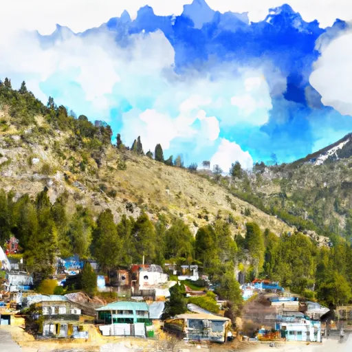
Zephyr Cove is a charming community located on the eastern shore of Lake Tahoe in Nevada. It experiences a semi-arid climate with warm, dry summers and snowy winters. The average temperature in summer ranges from 70°F to 80°F, while in winter, it fluctuates between 20°F and 40°F. The area receives an average of 300 days of sunshine annually.
Zephyr Cove is renowned for its stunning natural beauty and abundant outdoor recreation opportunities. The crystal-clear waters of Lake Tahoe offer excellent swimming, boating, and fishing experiences. The lake is also a popular spot for kayaking, paddleboarding, and jet skiing.
Hiking enthusiasts can explore the nearby trails, such as the Tahoe Rim Trail and Zephyr Cove Resort Trail, which provide breathtaking views of the surrounding mountains and forests. Winter activities include skiing and snowboarding at the nearby Heavenly Mountain Resort, as well as snowshoeing and cross-country skiing in the serene backcountry.
For those interested in hydrology, Lake Tahoe is known for its exceptional water clarity, providing a unique ecosystem for various aquatic species. The lake's water quality is closely monitored, and efforts to preserve its pristine condition are ongoing.
Overall, Zephyr Cove offers a picturesque setting, a mild climate, and a plethora of outdoor recreational activities for visitors and residents to enjoy throughout the year.
What is the Eden Index?
The Snoflo Eden Index serves as a comprehensive rating system for regions, evaluating their desirability through a holistic assessment of climate health, outdoor recreation opportunities, and natural disaster risk, acknowledging the profound impact of these factors on livability and well-being.
Climate Health Indicator (CHI): 8.4
Zephyr-Cove receives approximately
651mm of rain per year,
with humidity levels near 60%
and air temperatures averaging around
7°C.
Zephyr-Cove has a plant hardyness factor of
7, meaning
plants and agriculture in this region tend to thrive during the non-winter months.
By considering the ideal temperature range, reliable water supplies, clean air, and stable seasonal rain or snowpacks, the Climate Health Indicator (CHI) underscores the significance of a healthy climate as the foundation for quality living.
A healthy climate is paramount for ensuring a high quality of life and livability in a region, fostering both physical well-being and environmental harmony. This can be characterized by ideal temperatures, reliable access to water supplies, clean air, and consistent seasonal rain or snowpacks.
Weather Forecast
Streamflow Conditions
Truckee
Area Rivers
Truckee
Snowpack Depths
Truckee
Reservoir Storage Capacity
Truckee
Groundwater Levels
Recreational Opportunity Index (ROI): 10.0
The Recreational Opportunity Index (ROI) recognizes the value of outdoor recreational options, such as parks, hiking trails, camping sites, and fishing spots, while acknowledging that climate plays a pivotal role in ensuring the comfort and consistency of these experiences.
Access to outdoor recreational opportunities, encompassing activities such as parks, hiking, camping, and fishing, is crucial for overall well-being, and the climate plays a pivotal role in enabling and enhancing these experiences, ensuring that individuals can engage in nature-based activities comfortably and consistently.
Camping Areas
| Campground | Campsites | Reservations | Toilets | Showers | Elevation |
|---|---|---|---|---|---|
| Nevada Beach | 54 | 6,213 ft | |||
| Campground by the Lake | 170 | 6,256 ft | |||
| Fallen Leaf | 206 | 6,345 ft | |||
| El Dorado | None | 6,255 ft | |||
| Camp Richardson Complex | 320 | 6,250 ft | |||
| William Kent | 95 | 6,337 ft | |||
| D.L. Bliss State Park | 170 | 6,872 ft | |||
| Sugar Pine Point State Park | 175 | 6,465 ft | |||
| Camp Shelley | None | 6,256 ft | |||
| Meeks Bay | 40 | 6,225 ft |
Nearby Ski Areas
Catastrophe Safeguard Index (CSI):
The Catastrophe Safeguard Index (CSI) recognizes that natural disaster risk, encompassing floods, fires, hurricanes, and tornadoes, can drastically affect safety and the overall appeal of an area.
The level of natural disaster risk in a region significantly affects safety and the overall livability, with climate change amplifying these risks by potentially increasing the frequency and intensity of events like floods, fires, hurricanes, and tornadoes, thereby posing substantial challenges to community resilience and well-being.
Community Resilience Indicator (CRI): 2.4
The Community Resilience Indicator (CRI) recognizes that education, healthcare, and socioeconomics are crucial to the well-being of a region. The CRI acknowledges the profound impact of these elements on residents' overall quality of life. By evaluating educational resources, healthcare accessibility, and economic inclusivity, the index captures the essential aspects that contribute to a thriving community, fostering resident satisfaction, equity, and social cohesion.