Crossing Of Forest Road 96 To Coconino National Forest Boundary River Run
Community Reviews
Been here? Share the conditions.
Reviews, ratings & photos are added in the free Snoflo iOS app — rate a spot, tag the conditions, and your visit is verified by location. Add or manage your reviews from the app.
Crossing Of Forest Road 96 To Coconino National Forest Boundary
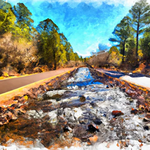
The segment is approximately 8 miles long, starting at the Forest Road 96 crossing and ending at the Coconino National Forest boundary. The river flows through a picturesque red rock canyon, providing stunning views for paddlers.
There are specific regulations that apply to this area. All visitors are required to have a permit to paddle the Whitewater River Run segment. Permits are available through the Coconino National Forest website or from local outfitters. Visitors must also adhere to Leave No Trace principles and avoid damaging vegetation or disturbing wildlife.
Overall, the Whitewater River Run Crossing of Forest Road 96 to Coconino National Forest Boundary is an exciting and challenging whitewater destination that requires skill and experience to navigate safely. Paddlers should always be aware of changing water levels and weather conditions to ensure a safe and enjoyable trip.
Plan your run down to the hour
Same weather feed Snoflo's iOS app uses -- updated continuously from NOAA / yr.no. Watch the precipitation column on the meteogram; rain ahead of a run typically lifts flows 12-48 hours later depending on the basin.
Next 5 days, hour by hour
Temperature line with weather symbols on top, snow + rain accumulation as columns, humidity as a dotted line.
5-day forecast table
Every 3 hours, broken out across temperature, snow, rain, humidity, and wind. Each cell is colour-coded relative to the column min/max.
| Time | Condition | Temp (°F) | Snow (in) | Rain (in) | Humidity (%) | Wind (mps) | Wind dir |
|---|---|---|---|---|---|---|---|
| Loading detailed forecast… | |||||||
15-day temperature & precipitation
Daily temperatures, snow, and rain projected over the next two weeks -- the upstream story that drives next week's flows.
Regional streamflow levels
USGS streamgauges around Crossing Of Forest Road 96 To Coconino National Forest Boundary -- useful for spotting upstream pulses and gauging which tributary is contributing what.
| Streamgauge | Discharge | View |
|---|---|---|
| East Verde R Div From East Clear Cr Nr Pine | 3 cfs | → |
| Chevelon Fork Below Wildcat Canyon | · | → |
| Wet Beaver Creek Near Rimrock | 7 cfs | → |
| West Clear Creek Near Camp Verde | 14 cfs | → |
| Jacks Canyon Cr Nr Winslow | · | → |
| East Verde River Near Childs | 0 cfs | → |
Plan a longer trip
The closest boat launches, other paddle runs, and campgrounds so a day on the water can grow into a full weekend.
Other river runs
- Below Flow Structure In Sec 16, T12n,R11e To Confluence With Clear Creek
- Below The Dam At Knoll Lake To Confluence With East Clear Creek
- 1/4 Mile Below Wiggins Crossing To Confluence With Clear Creek
- Headwaters In Sec 14, T13n, R9e To Clear Creek Wilderness Boundary
- Christopher Creek
Campgrounds
- Rock Crossing
- Rock Crossing Campground
- Blue Ridge
- Blue Ridge Campground
- Moqui Group Campground
- Clints Well
Fishing spots
Whitewater safety
- Check the flow before you run
- Use the linked-gauge card and Regional Flow panel above. Class ratings change with flow -- a Class III at low water can become Class IV+ at high water.
- Know your skill ceiling
- Pick runs comfortably below your ceiling. Cold-water and big-water runs raise the consequences of any mistake.
- Wear the right gear
- Helmet, PFD, drysuit / wetsuit when water is below 60°F. Throw bag, knife, and whistle on your person, not in the boat.
- Scout, set safety, and run with a team
- Scout new rapids on foot, set safety with throw bags above the consequence pool, and run with at least one other competent paddler.
- Respect the river
- Strainers, undercuts, low-head dams, and wood can kill at any class rating. When in doubt, portage.
Set push alerts in the Snoflo app
Save Crossing Of Forest Road 96 To Coconino National Forest Boundary as a favorite, set a discharge threshold (e.g. "alert me when flow hits 600 cfs"), and the iOS app pushes the moment the linked gauge crosses.
About Crossing Of Forest Road 96 To Coconino National Forest Boundary
What's the optimal flow for Crossing Of Forest Road 96 To Coconino National Forest Boundary?
The optimal flow depends on the section and the craft. Check the Run Details panel for the linked gauge and current status.
How fresh is the cfs reading on this page?
The linked USGS streamgauge reports continuously (every 15 minutes); Snoflo refreshes throughout the day. Hover the streamflow sparkline to read individual datapoints.
What's the whitewater class?
See the Run Details panel for the class rating Snoflo tracks for this run. Class ratings change with flow -- a Class III at low water can become Class IV in high water.
Where do I put in / take out?
Tap Directions in the hero above to open driving directions to the put-in. For shuttle planning, check the Nearby Boat Launches panel and the river run operator's site.
Can I get alerts when flows hit the optimal range?
Yes -- alerts are managed in the Snoflo iOS app. Favorite this run, set a discharge threshold, and you'll get a push the moment the gauge crosses.
Other runs near here
Snoflo-tracked paddle runs within driving distance of Crossing Of Forest Road 96 To Coconino National Forest Boundary.