Wilderness Boundary To Confluence With Cave Creek river run
Community Reviews
Been here? Share the conditions.
Reviews, ratings & photos are added in the free Snoflo iOS app — rate a spot, tag the conditions, and your visit is verified by location. Add or manage your reviews from the app.
Wilderness Boundary To Confluence With Cave Creek
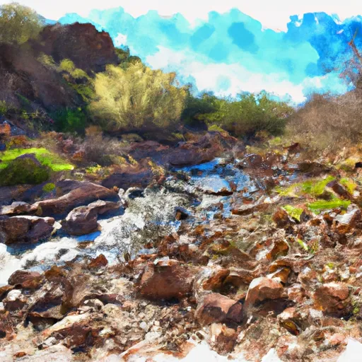
The Whitewater River Run is rated as a Class III-IV river, offering a mix of challenging rapids and calmer stretches for paddlers to enjoy. Some of the most notable rapids on this section of the river include Pinball, The Maze, and S-Turn. Paddlers will also encounter several large boulders and obstacles, which can add to the excitement of the trip.
The segment mileage for this section of the Whitewater River Run is 14.6 miles, starting at the Wilderness Boundary and ending at the Confluence with Cave Creek. The trip typically takes around 4-5 hours to complete, depending on the water conditions and the experience level of the paddlers.
There are several regulations to be aware of when planning a trip on the Whitewater River Run. All boaters must have a permit to access the river, and groups are limited to a maximum of 15 people. Additionally, all paddlers are required to wear a properly fitting personal flotation device (PFD) at all times, and camping is only allowed at designated campsites along the river.
Overall, the Whitewater River Run Wilderness Boundary to Confluence with Cave Creek is a challenging and rewarding journey for experienced paddlers. With ideal streamflow conditions, a mix of Class III-IV rapids, and stunning scenery, this section of the river is a must-visit destination for adventurous boaters.
Plan your run down to the hour
Same weather feed Snoflo's iOS app uses -- updated continuously from NOAA / yr.no. Watch the precipitation column on the meteogram; rain ahead of a run typically lifts flows 12-48 hours later depending on the basin.
Next 5 days, hour by hour
Temperature line with weather symbols on top, snow + rain accumulation as columns, humidity as a dotted line.
5-day forecast table
Every 3 hours, broken out across temperature, snow, rain, humidity, and wind. Each cell is colour-coded relative to the column min/max.
| Time | Condition | Temp (°F) | Snow (in) | Rain (in) | Humidity (%) | Wind (mps) | Wind dir |
|---|---|---|---|---|---|---|---|
| Loading detailed forecast… | |||||||
15-day temperature & precipitation
Daily temperatures, snow, and rain projected over the next two weeks -- the upstream story that drives next week's flows.
Regional streamflow levels
USGS streamgauges around Wilderness Boundary To Confluence With Cave Creek -- useful for spotting upstream pulses and gauging which tributary is contributing what.
| Streamgauge | Discharge | View |
|---|---|---|
| Leslie Creek Near Mcneal | · | → |
| Whitewater Draw Near Douglas | 0 cfs | → |
| Banning Creek Near Bisbee | · | → |
| Gila River Below Blue Creek | 0 cfs | → |
| Gila River At Duncan | 12 cfs | → |
| San Pedro River Near Tombstone | 5 cfs | → |
Plan a longer trip
The closest boat launches, other paddle runs, and campgrounds so a day on the water can grow into a full weekend.
Other river runs
- Cower Cave Creek - Wilderness Boundary To Coronado National Forest Boundary (Near Portal)
- Headwaters To Wilderness Boundary
- Cima Creek - Headwaters To Wilderness Boundary
- Headwaters Within Wilderness To Wilderness Boundary
- Gila
Campgrounds
Parks
Whitewater safety
- Check the flow before you run
- Use the linked-gauge card and Regional Flow panel above. Class ratings change with flow -- a Class III at low water can become Class IV+ at high water.
- Know your skill ceiling
- Pick runs comfortably below your ceiling. Cold-water and big-water runs raise the consequences of any mistake.
- Wear the right gear
- Helmet, PFD, drysuit / wetsuit when water is below 60°F. Throw bag, knife, and whistle on your person, not in the boat.
- Scout, set safety, and run with a team
- Scout new rapids on foot, set safety with throw bags above the consequence pool, and run with at least one other competent paddler.
- Respect the river
- Strainers, undercuts, low-head dams, and wood can kill at any class rating. When in doubt, portage.
Set push alerts in the Snoflo app
Save Wilderness Boundary To Confluence With Cave Creek as a favorite, set a discharge threshold (e.g. "alert me when flow hits 600 cfs"), and the iOS app pushes the moment the linked gauge crosses.
About Wilderness Boundary To Confluence With Cave Creek
What's the optimal flow for Wilderness Boundary To Confluence With Cave Creek?
The optimal flow depends on the section and the craft. Check the Run Details panel for the linked gauge and current status.
How fresh is the cfs reading on this page?
The linked USGS streamgauge reports continuously (every 15 minutes); Snoflo refreshes throughout the day. Hover the streamflow sparkline to read individual datapoints.
What's the whitewater class?
See the Run Details panel for the class rating Snoflo tracks for this run. Class ratings change with flow -- a Class III at low water can become Class IV in high water.
Where do I put in / take out?
Tap Directions in the hero above to open driving directions to the put-in. For shuttle planning, check the Nearby Boat Launches panel and the river run operator's site.
Can I get alerts when flows hit the optimal range?
Yes -- alerts are managed in the Snoflo iOS app. Favorite this run, set a discharge threshold, and you'll get a push the moment the gauge crosses.
Other runs near here
Snoflo-tracked paddle runs within driving distance of Wilderness Boundary To Confluence With Cave Creek.