Agua Fria River river run
Community Reviews
Been here? Share the conditions.
Reviews, ratings & photos are added in the free Snoflo iOS app — rate a spot, tag the conditions, and your visit is verified by location. Add or manage your reviews from the app.
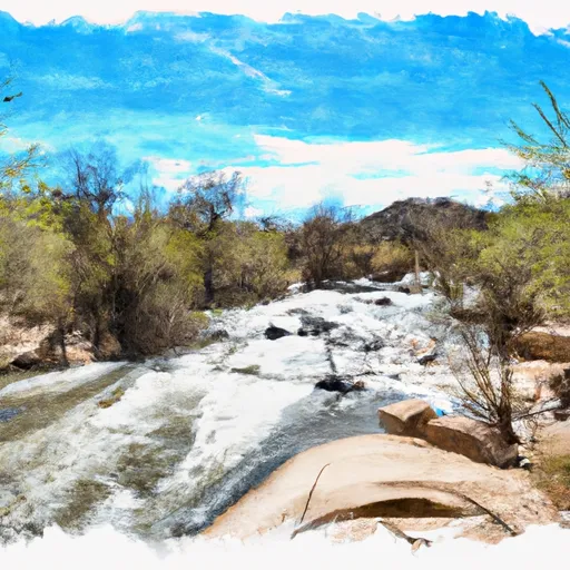
Agua Fria River
The Agua Fria River is divided into two segments for rafting purposes: the upper section and the lower section. The upper section has a length of approximately 14 miles and features several rapids, including Black Rock Rapid, which is a Class III rapid. The lower section is shorter at around 6 miles and is less challenging than the upper section.
One of the main obstacles on the Agua Fria River is the Black Rock Rapid, which is a Class III rapid with a steep drop and a large rock in the middle of the rapid. Other obstacles on the river include small drops, waves, and eddies.
There are specific regulations that apply to rafting on the Agua Fria River. All participants must wear a life jacket and helmet while on the river. It is also recommended that participants have prior whitewater rafting experience before attempting the Agua Fria River.
In conclusion, the Agua Fria River is a popular destination for whitewater rafting enthusiasts in Arizona. It has an ideal streamflow range of 500-800 cfs and is rated as Class II-III. The river is divided into two sections and features several rapids and obstacles, including Black Rock Rapid. There are specific regulations that apply to rafting on the Agua Fria River, including the use of life jackets and helmets.
Plan your run down to the hour
Same weather feed Snoflo's iOS app uses -- updated continuously from NOAA / yr.no. Watch the precipitation column on the meteogram; rain ahead of a run typically lifts flows 12-48 hours later depending on the basin.
Next 5 days, hour by hour
Temperature line with weather symbols on top, snow + rain accumulation as columns, humidity as a dotted line.
5-day forecast table
Every 3 hours, broken out across temperature, snow, rain, humidity, and wind. Each cell is colour-coded relative to the column min/max.
| Time | Condition | Temp (°F) | Snow (in) | Rain (in) | Humidity (%) | Wind (mps) | Wind dir |
|---|---|---|---|---|---|---|---|
| Loading detailed forecast… | |||||||
15-day temperature & precipitation
Daily temperatures, snow, and rain projected over the next two weeks -- the upstream story that drives next week's flows.
Regional streamflow levels
USGS streamgauges around Agua Fria River -- useful for spotting upstream pulses and gauging which tributary is contributing what.
| Streamgauge | Discharge | View |
|---|---|---|
| Agua Fria River Near Mayer | 1 cfs | → |
| Agua Fria River Near Rock Springs | · | → |
| New River Near Rock Springs | · | → |
| Cave Creek Blw Cottonwood Cr Near Cave Creek | · | → |
| Verde R Blw Tangle Creek | 54 cfs | → |
| Agua Fria River Near Humboldt | 0 cfs | → |
Plan a longer trip
The closest boat launches, other paddle runs, and campgrounds so a day on the water can grow into a full weekend.
Campgrounds
- Agua Fria National Monument
- Agua Fria National Monument Dispersed
- Kentuck Springs
- Kentuck Spring Campground
- Hazlett Hollow
- Hazlett Hollow Campground
Fishing spots
- Horsethief Boating Site / Day Use Area
- Horsethief Lake
- North Canyon Creek
- Lake Pleasant
- West Clear Creek
- Deadman Creek
Whitewater safety
- Check the flow before you run
- Use the linked-gauge card and Regional Flow panel above. Class ratings change with flow -- a Class III at low water can become Class IV+ at high water.
- Know your skill ceiling
- Pick runs comfortably below your ceiling. Cold-water and big-water runs raise the consequences of any mistake.
- Wear the right gear
- Helmet, PFD, drysuit / wetsuit when water is below 60°F. Throw bag, knife, and whistle on your person, not in the boat.
- Scout, set safety, and run with a team
- Scout new rapids on foot, set safety with throw bags above the consequence pool, and run with at least one other competent paddler.
- Respect the river
- Strainers, undercuts, low-head dams, and wood can kill at any class rating. When in doubt, portage.
Set push alerts in the Snoflo app
Save Agua Fria River as a favorite, set a discharge threshold (e.g. "alert me when flow hits 600 cfs"), and the iOS app pushes the moment the linked gauge crosses.
About Agua Fria River
What's the optimal flow for Agua Fria River?
The optimal flow depends on the section and the craft. Check the Run Details panel for the linked gauge and current status.
How fresh is the cfs reading on this page?
The linked USGS streamgauge reports continuously (every 15 minutes); Snoflo refreshes throughout the day. Hover the streamflow sparkline to read individual datapoints.
What's the whitewater class?
See the Run Details panel for the class rating Snoflo tracks for this run. Class ratings change with flow -- a Class III at low water can become Class IV in high water.
Where do I put in / take out?
Tap Directions in the hero above to open driving directions to the put-in. For shuttle planning, check the Nearby Boat Launches panel and the river run operator's site.
Can I get alerts when flows hit the optimal range?
Yes -- alerts are managed in the Snoflo iOS app. Favorite this run, set a discharge threshold, and you'll get a push the moment the gauge crosses.
Other runs near here
Snoflo-tracked paddle runs within driving distance of Agua Fria River.