Just Below Highway 36 Crossing To One-Half Mile Downstream From Hole-In-The-Ground River Run
Community Reviews
Been here? Share the conditions.
Reviews, ratings & photos are added in the free Snoflo iOS app — rate a spot, tag the conditions, and your visit is verified by location. Add or manage your reviews from the app.
Just Below Highway 36 Crossing To One-Half Mile Downstream From Hole-In-The-Ground
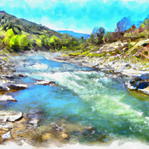
The segment mileage for this section of the Whitewater River run is about 4 miles, starting just below Highway 36 Crossing and ending one-half mile downstream from Hole-in-the-Ground. This section of the river features several challenging rapids, including "The Chute," "The Maze," and "The Squeeze." These rapids require careful maneuvering to avoid obstacles such as rocks and strainers.
There are specific regulations for this area that must be followed to ensure safety and preserve the natural environment. All participants must wear a personal flotation device (PFD) and helmets are strongly recommended. Camping and fires are not permitted in the area. Respect for wildlife and the environment is also required.
Overall, the Whitewater River Run Just Below Highway 36 Crossing To One-Half Mile Downstream From Hole-In-The-Ground in California is a thrilling whitewater experience that requires skill and caution. It is important to follow all regulations and safety precautions to ensure a successful and enjoyable trip.
Plan your run down to the hour
Same weather feed Snoflo's iOS app uses -- updated continuously from NOAA / yr.no. Watch the precipitation column on the meteogram; rain ahead of a run typically lifts flows 12-48 hours later depending on the basin.
Next 5 days, hour by hour
Temperature line with weather symbols on top, snow + rain accumulation as columns, humidity as a dotted line.
5-day forecast table
Every 3 hours, broken out across temperature, snow, rain, humidity, and wind. Each cell is colour-coded relative to the column min/max.
| Time | Condition | Temp (°F) | Snow (in) | Rain (in) | Humidity (%) | Wind (mps) | Wind dir |
|---|---|---|---|---|---|---|---|
| Loading detailed forecast… | |||||||
15-day temperature & precipitation
Daily temperatures, snow, and rain projected over the next two weeks -- the upstream story that drives next week's flows.
Regional streamflow levels
USGS streamgauges around Just Below Highway 36 Crossing To One-Half Mile Downstream From Hole-In-The-Ground -- useful for spotting upstream pulses and gauging which tributary is contributing what.
| Streamgauge | Discharge | View |
|---|---|---|
| Hat C Nr Hat Creek Ca | 127 cfs | → |
| Deer C Nr Vina Ca | 99 cfs | → |
| Mill C Nr Los Molinos Ca | 136 cfs | → |
| Battle C Bl Coleman Fish Hatchery Nr Cottonwood Ca | 238 cfs | → |
| Sacramento R Ab Bend Bridge Nr Red Bluff Ca | 13,200 cfs | → |
| Cottonwood C Nr Cottonwood Ca | 63 cfs | → |
Plan a longer trip
The closest boat launches, other paddle runs, and campgrounds so a day on the water can grow into a full weekend.
Other river runs
- One-Half Mile Downstream From Hole-In-The-Ground To Sec Line Between 29/20 T28n, R3e, Below Big Bend
- Lassen Np Boundary To Just Below Highway 36 Crossing
- Elam Creek Campground To Deer Creek-Highway 32 Junction
- South Fork Battle Creek
- Deer Creek-Highway 32 Junction To Sec 26, T27n, R3e, West Of Deer Creek Crossing
Campgrounds
- Hole In The Ground
- Hole-In-The-Ground Campground
- Battle Creek
- Battle Creek Campground
- Gurnsey Creek Group Campground
- Elam Campground
Fishing spots
Whitewater safety
- Check the flow before you run
- Use the linked-gauge card and Regional Flow panel above. Class ratings change with flow -- a Class III at low water can become Class IV+ at high water.
- Know your skill ceiling
- Pick runs comfortably below your ceiling. Cold-water and big-water runs raise the consequences of any mistake.
- Wear the right gear
- Helmet, PFD, drysuit / wetsuit when water is below 60°F. Throw bag, knife, and whistle on your person, not in the boat.
- Scout, set safety, and run with a team
- Scout new rapids on foot, set safety with throw bags above the consequence pool, and run with at least one other competent paddler.
- Respect the river
- Strainers, undercuts, low-head dams, and wood can kill at any class rating. When in doubt, portage.
Set push alerts in the Snoflo app
Save Just Below Highway 36 Crossing To One-Half Mile Downstream From Hole-In-The-Ground as a favorite, set a discharge threshold (e.g. "alert me when flow hits 600 cfs"), and the iOS app pushes the moment the linked gauge crosses.
About Just Below Highway 36 Crossing To One-Half Mile Downstream From Hole-In-The-Ground
What's the optimal flow for Just Below Highway 36 Crossing To One-Half Mile Downstream From Hole-In-The-Ground?
The optimal flow depends on the section and the craft. Check the Run Details panel for the linked gauge and current status.
How fresh is the cfs reading on this page?
The linked USGS streamgauge reports continuously (every 15 minutes); Snoflo refreshes throughout the day. Hover the streamflow sparkline to read individual datapoints.
What's the whitewater class?
See the Run Details panel for the class rating Snoflo tracks for this run. Class ratings change with flow -- a Class III at low water can become Class IV in high water.
Where do I put in / take out?
Tap Directions in the hero above to open driving directions to the put-in. For shuttle planning, check the Nearby Boat Launches panel and the river run operator's site.
Can I get alerts when flows hit the optimal range?
Yes -- alerts are managed in the Snoflo iOS app. Favorite this run, set a discharge threshold, and you'll get a push the moment the gauge crosses.
Other runs near here
Snoflo-tracked paddle runs within driving distance of Just Below Highway 36 Crossing To One-Half Mile Downstream From Hole-In-The-Ground.